In a post last fall, I shared a photograph taken from the summit of Twin Mountain and made the point that after years of admiring the Catskills from the vantage of the Shawangunks, I had for the first time made the reverse connection.
Last weekend I returned to Twin Mountain, but this time with my friend Steve Aaron, who is a talented landscape photographer. And this time I saw something new….

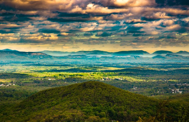
Northern Shawangunks, seen from Twin Mountain in the Catskills. Photo: Steve Aaron Photography
Over the years, I’ve logged countless miles running and hiking in the Shawangunks and from many vantage points seen the Catskills looming above the northern horizon, rugged and massive.
Over the years, I’ve climbed the southern peaks in the Catskills dozens of times. Looking down from this jagged mountain wall, the landscape rolls off to the horizon in waves of blue and green. It was a long time before I thought to search for the Gunks in this sea of undulating colors. I finally caught a glimpse of them last year, from the summit of Twin Mountain on a cloudy fall day, when the mists parted to reveal the distinctive twisted broken plates of the northern Shawangunk ridgeline, and sitting on the highest point, barely visible, was Skytop Tower. When I told Steve, he wanted to experience this view.
Last Saturday we drove up to the Catskills, parked, and hiked in 2.5 miles through a towering forest of maple, oak, cherry, and hemlock until we arrived at the Jimmy Dolan Notch. From there we began the scramble up to the eastern summit of Twin Mountain and soon entered a boreal environment of spruce, fir, birch, and mountain ash. Along the way a rock ledge offered a clear view of Indian Head, rising abruptly on our left, where thousands of years ago melting glacial waters had carved a channel in the mountain wall and then poured into the valleys below. A few steps later we discovered pinxterbloom azalea bushes with sprays of flowers, bright pink and fragant. Arriving at the summit, we could see the Hudson River gleaming off to the left, the Ashokan Reservoir sitting below us, and the southern Catskills ranging off into the distance. But I couldn’t find the Shawangunks. Moving around to different points on the rock terrace, it became apparent that the Gunks were screened by a grove of fir trees. Stepping onto a rock, I peered between branches and there was that distinctive ridgeline, looking like a breaking wave.
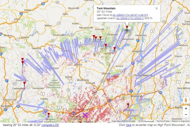
We got a clearer view of the Gunks from the western summit of Twin mountain, which is where Steve took the photo shown above. Then we returned to the notch, checked the time, and decided to clamber up to Indian Head. And from this summit, I was able to grasp the entire range of the Shawangunk Mountains — not just Skytop and the northern Gunks, but the long southwest continuation of the ridge until it appeared to fall off into the distance. I stared long and hard, and now it seemed there was a prominence floating in the haze — although it wasn’t clear whether I was seeing it, or imagining it. Surely, this was High Point in New Jersey.


It was hard to be sure. We used a compass function on Steve’s phone to shoot an azimuth, and then turned back.
High Point has a special significance for me: it marks the southern terminus of the Shawangunk Ridge Trail, which traverses the entire Gunks ridgeline for a distance of 70 miles, ending in the town of Rosendale. I had fallen in love with the Shawangunk Ridge Trail after thru-running it in 2014 and subsequently organized a foot race along the trail in 2014 and 2015.
Once back home, I verified that there is a direct line of sight from High Point, NJ to the summit of Twin Mountain, consistent with the azimuth we had shot. The distance is 62 miles. On a very clear day, you might be able to see the monument tower that rises from the summit of High Point.

There are a handful of special vantage points in the Hudson Valley that offer panoramic views of the Shawangunks. Steve took the picture below from the summit of Schunemunk Mountain, which lies further south along the Hudson River across from Beacon, New York. In this photo, the Shawangunks can be seen in the foreground, the white conglomerate cliffs glistening in the broken sunlight, while the southern Catskills lie behind them some 30 miles further north, towering 1,500 feet above. I’ve been on Schunemunk twice, and both times I was stunned by the vistas, especially of the Catskills, but never thought to look for the Shawangunks. I’ll have to go back.
If you like Steve’s images, then you will be happy to know that he and I are organizing an exhibition of his photographs called Discovering the Long Path: Images of New York’s Greatest Trail. The exhibition will open in September at the New York-New Jersey Trail Conference’s headquarters in Mahwah, NJ, and then travel to other galleries in the Hudson Valley.
To learn something new, take the path you took yesterday
— John Burroughs

Breathtaking views!
LikeLike
I’ll be hiking Hunter tomorrow, and this post has inspired and reminded me to take a good look at the Gunks from the firetower there.
LikeLiked by 1 person
Have an awesome hike. Last time there I made it up 1/2 way but Odie didn’t like hanging out at the bottom by himself, so I turned around and came down
LikeLike
[…] here, you can see the Shawangunk Mountains to the south; earlier this spring, I had taken in that view with landscape photographer Steve Aaron, but today the horizon was shrouded in mist. There was […]
LikeLike
[…] the second time, I paused for a little longer this time to study the view. To the south, the Shawangunk Mountains were visible as a dark gray ridge, but the two towers that mark the northern and southern […]
LikeLike
[…] exploring the Catskills, I pointed out the neighboring peaks and other landmarks, including the Shawangunk Mountains, which you can just make out if you stand tip-toe on a rock and look between some fir […]
LikeLike