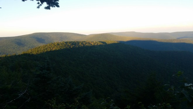
On the drive up to the Catskills, the rising sun was hidden behind a wall of murky fog, but its rays reached out from behind and scattered across the sky, brushing the undersides of clouds with the color and texture of beaten copper.
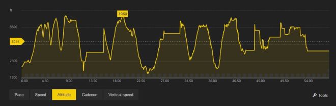
My mission this morning was to take on the Devil’s Path, one of the most notorious hiking trails in the country — and not just once, but twice. This meant a total distance of 48 miles and something like 28,000 feet of cumulative elevation gain. The purpose was to whip myself into shape for an upcoming solo run in the Catskills, as well as experience the Devil’s Path in its entirety, something I had never done before.
As the drive progressed, the murky fog spread across the sky, darkening the forests. After parking, packing up, activating personal locator beacon and starting GPS watch, I headed out on the trail, trotting slowly in the gloom. Somewhere in the woods a hermit thrush sang its haunting song and then fell silent. From time to time, a sparrow chattered, but otherwise the woods were still.
Hemlocks, sugar maple, yellow birch, and black cherry rose above the path, while club moss, evergreen ferns, and hobble-bush crowded the sides. Mushrooms and other kinds of fungus caught my eye with splashes of color, bright yellow, orange, red, and brown (the red toadstool with white spots is fly amanita, Amanita muscaria).


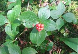
I noticed a small plant with four ovate leaves with smooth margins and parallel veins and clusters of bright red berries. The plant reminded me of the dogwood tree, and I learned afterwards from Catskills forest expert Mike Kudish that it’s Cornus canadensis which is called dwarf dogwood or bunch berry and it is indeed a member of the same family as the dogwood tree. Strange to see a mid-sized tree transmogrified into a small plant creeping along the ground!
The climb up to Indian Head is roughly 1250 feet, but on fresh legs it went by quickly. There’s one daunting rock face that requires grasping onto roots and other handholds, but soon enough here was Sherman’s Lookout, a vantage point with views of Plattekill and Overlook mountains to the east.
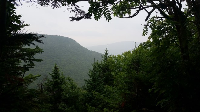
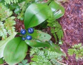
The descent into Jimmy Dolan notch is only about 500 feet, and then it’s back up 500 feet to the summit of Twin Mountain. From here, you can see the Shawangunk Mountains to the south; earlier this spring, I had taken in that view with landscape photographer Steve Aaron, but today the horizon was shrouded in mist. There was plenty to see by the side of the trail, though, including a lily with bright blue berries, miniature forests of shaggy cladonia lichen sprouting on tree stumps, tapestries of moss woven from many different species, and more mushrooms.
The descent from Twin Mountain is close to 1,000 feet, and midway down I passed a couple of hikers and a group of runners, all of whom were aiming to complete the Devil’s Path today. It was starting to drizzle; I wished them well and edged past them over a group of large fractured blocks of rock that were becoming slick with moisture.
A sudden drenching shower caught up to me on Sugar Loaf, but the temperature remained warm, and the precipitation was not uncomfortable. In weather like this, running without a shirt makes the most sense, as the water rolls off the skin, keeping you cool, while fabric would get clammy and chafe.
I tried to run where possible, but whenever the trail flattened out for even a moment it seemed to get wet and muddy, and I couldn’t develop any rhythm. I had spent most of the summer training on paved roads in anticipation of a long run in Death Valley, but plans fell through; I was glad to return to the Catskills, but wished I had done more hill training.
On Plateau Mountain I encountered a small toad, which seemed like an appropriate creature to keep watch over the Devil’s private domain, as early colonists regarded the jagged mountain escarpment through which the Devil’s Path wends its way. Toads made me think of frogs and newts, and suddenly the witches’ chorus from Shakespeare’s Macbeth came to mind:
Double, double toil and trouble;Fire burn and caldron bubble.Fillet of a fenny snake,In the caldron boil and bake;Eye of newt and toe of frog,Wool of bat and tongue of dog,Adder’s fork and blind-worm’s sting,Lizard’s leg and howlet’s wing,For a charm of powerful trouble,Like a hell-broth boil and bubble.Double, double toil and trouble;Fire burn and caldron bubble.Cool it with a baboon’s blood,Then the charm is firm and good.
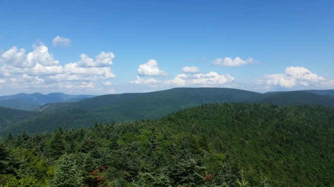
There’s a vantage point on the northwestern corner of Plateau called Orchard Point. The rain had passed, the sky had cleared, the humidity had dropped, and it was now about as beautiful a summer day as you could ask for. I stared out at the distinctive silhouette of the Blackhead Range, which includes Thomas Cole Mountain, Black Dome, and Black Head, which I had climbed most recently last winter.
The descent from Plateau is abrupt, about 1500 feet in just over a mile, with a grade of 25% or higher on the worst spots, and the trail is very rocky as is typical of old washed-out logging roads. I hopped down from rock to rock, along the way passing a father and daughter who were toiling upwards. “That’s one fit man,” the father commented to his daughter, which of course made me smile (who doesn’t like a compliment!), but I responded cautiously, “We’ll see how I’m doing on the way back.”
At the bottom of the valley, the trail crosses route 214 and enters the Devils’ Tombstone campground, and this marks mile 12 or the 1/2 way point for the Devil’s Path. For me, with ambitions to do the double, this meant my journey was 25% completed, which was an encouraging statistic, and so far I was still feeling pretty good. As an added bonus, there was a water faucet in the campground which saved me from having to filter water from a stream. I was carrying two soft bottles which added up to a single liter, and once filled, I moved out.
From the campground, the Devil’s Path climbs 1500 feet up and over the shoulder of Hunter Mountain and takes you past a lean-to and then the unmarked trail to Southwest Hunter, before descending and crossing the West Kill stream at Diamond Notch Falls, and then it’s up 1500 feet again to the summit of Westkill. Just shy of the summit, Buck Ridge Lookout offers a view back towards Southwest Hunter. The path was bright in the afternoon sunlight, a breeze rustled leaves high in the trees, streams trickled down the mountain slopes, and it was hard not to appreciate being outdoors on day like this.
The Devil’s Path ends at a trailhead on Spruceton Road, and from the summit of Westkill, it’s all downhill. I finally emerged from the forest into a small parking area in the rather leisurely cumulative time of ten hours, more than double Ben Nephew’s fastest known time of 4:53. The differential between me and Ben can be explained by the fact that Ben is one of the most formidable mountain racers in the country, while I am a middle-of-the-packer. Also, I’d kept the pace somewhat conservative, knowing energy would be needed for the return trip.
It was time to sit down and eat some pemmican, my first nutrition since breakfast before the start. It occurred to me that as far as training went, completing a one-way trip along the Devil’s Path was a good day’s work, and perhaps it wasn’t strictly necessary to do the double. A good idea, but my car was back at the Prediger Road trailhead, 24 miles away, with no easy shortcuts to get there. Maybe some of the runners and hikers I’d passed earlier would appear, I thought wistfully, and offer me a ride back to the start. I hung out for a bit, but no-one showed up. After a little while I gave up and headed back up the trail, thinking if someone materialized in the first mile or so, I could discretely inquire if they were headed back to Prediger. But the trail was empty.
My water had run out again, so I stopped next to a stream and pulled out my water filter. Just as I finished and stood up, a woman came trotting down the trail and jumped in surprise to see me — explaining as she passed that she had been “in her own world.” A little while later I stepped to the side to let a downhill hiker pass, and when he saw me, he, too, was startled. I was scaring people left and right — perhaps this is what happens if you spend enough time on the Devil’s Path.
Four miles in I encountered the runners once again, but it was too late to beg a ride — we traded greetings and went our separate ways. The sun was sinking. I moved along purposefully wanting to get as far as possible before dark. Returning to Buck Ridge Ledge at the summit of Westkill, I found the sun’s rays were cutting almost horizontally across the top of Southwest Hunter; the distant mountains were glowing in the fading light, while the foreground was plunged in shade.
It was pitch black by the time I rounded the shoulder on Hunter and passed the lean-to once again. Three young men were standing around the fire, cooking dinner. I stopped to say hello and then moved along, not wanting to come across like an uninvited dinner guest.
The descent into Devil’s Tombstone was slow. At the bottom, I refilled water bottles at the faucet and then parked myself at a picnic table where I ate some more pemmican, nibbled on a square of dark chocolate, and watched campers moving between tents, lights in hand, as the scent of campfires hung in the air.
And then it was time for Plateau, and just as expected, I was no longer feeling like the “fit man” who had impressed the father-daughter team earlier in the day. The 25% grade 1500-foot climb was grueling.
Upon arriving at the Orchard Point ledge, I saw distant lights and felt the wind blowing across the valley, tussling the trees, chilling my shoulders and arms. My breath steamed in the light of the headlamp.
Plateau’s long flat top was a nice break from the climbing, but my quads were too tired to run, so I kept up a fast power hike and felt good to be still moving purposefully if not rapidly. I kept an eye out for the turn-off to Warner Creek, which is part of the Long Path and the Manitou’s Revenge 54-mile ultramarathon, but it sneaked by in the dark unseen.
The descent from Plateau was awful. Steep, treacherous, endless. With quad muscles trashed, my form was deteriorating: instead of landing lightly on the forefoot, I was crashing down on my heels, and the shock waves were tiring my lower back. This is how I used to run a long time ago, before minimalist and barefoot running helped improve my form. At some point, I found myself on the top of Sugar Loaf, stepping through muddy water.

Distance was no longer meaningful, it was all about climbs and descents. “Three more climbs and three more descents” is what I had told myself at the base of Sugar Loaf, and now that I had reached the top, it was “two more climbs and three more descents.”
More toads appeared on the trail. Then I saw a northern coal skink. A rabbit hopped across the path, took a look at me, and disappeared into the forest. It seemed to me that these creatures’s job was to keep an eye on human intruders, especially those who were presumptuous enough to cross through the Devil’s domain not once, but twice.


Somehow I got up to the top of Twin Mountain. From the summit ledge, I knew there was a direct line of sight to Skytop Tower in the Shawangunks. And there was a solitary yellow light hanging in the darkness in the right direction. But upon reflection, this seemed too close. Skytop is 30 or 40 miles away.
Reaching the base of Indian Head, I felt relieved to be facing the very last climb, and one of the shorter ones. I was getting confused, however, by the distances marked on the signs and became convinced that the end of the trail was only three miles away — although part of me thought that seemed too short.
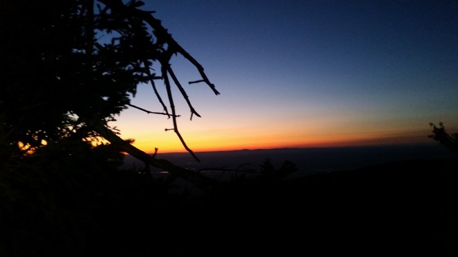
At the top of Indian Head, I checked my Trail Conference map, and it seemed there were still three miles to go, even though I should have just covered a half a mile of that. And then once I was hiking down the backside, another sign revealed there were once again three miles to go. It seemed that the signs and maps did not agree, and I understood that in my tired condition, the mind would tend to jump ahead, grasping for any data that would suggest the journey was almost over. There was nothing to do but keep moving. The sky flared a deep orange, as if precious metals had been melted in a forge and were pooling beyond the horizon.
Meanwhile, my Suunto GPS watch was clicking off the miles at a surprising rate. According to simple math, the full trip should have been 48 miles (2 X 24), but the watch showed 55 miles and I still wasn’t back to the start. There were two possible explanations: that the normally-reliable instrument had malfunctioned, or alternatively that the forces of darkness, alerted by the toads and rabbits to my presence, had cast a spell that stretched the trail out like a rubber band in front of me, forcing me to cover a much longer distance than I should have. No doubt these spirits were toying with me, like cats with a mouse, their purpose being to teach foolish mortals a little humility.
The sky lightened, dispersing the shadows. I was steadily making my way toward Prediger, although it was somehow still three miles to go, and every turn in the trail seemed to take an extraordinarily long time to reach. Suddenly the song of the hermit thrush broke out just above my head, a short clear whistle followed by a series of tremulous notes, the sequence then alternated in a different key. One bird’s call was echoed by another, treating me to a chorus of thrush music during the final two miles back to the car.
Total time was just under 24 hours, for 48 miles (by the map) or 58 (by the watch).
For the next few days, my legs hurt so much, I could barely walk. But by the end of the week, I was able to run a few miles below an 8:00 minute pace and felt pretty good — until my calf tightened up — my last reminder, I hope, to be respectful of the Devil’s private refuge.


[…] seen and heard these tiny birds in the valley, I was surprised to encounter them again in the Catskills and the Adirondacks. They seem to get […]
LikeLike
[…] Down in the valley, a stout little bird is hopping along on the ground: brown on back, white chest with brown marks, short beak, narrow tail, white ring around black eye — it’s a hermit thrush, the first I’ve ever seen, although I’ve heard its song so many times, including right in this spot when I was finishing the Devil’s Path Double. […]
LikeLike
[…] this evening. I remind them to be thoughtful on the Devil’s Path (lest they antagonize the forces of darkness), but they’ve been there before and have already anticipated some of today’s likely […]
LikeLike