Notes on some of the other Catskills hikes that took place this month, with a special focus on views, birds, and battling the last remnants of snow and ice…
April 10, 2018 — Bearpen & Vly
- The strategy is take it easy: just get a couple more peaks done during this early spring period, when everything is still covered in snow, and save the big push for later in the month, when it will be warmer, drier, easier.
- On the drive up, I’m constantly scanning the surroundings for signs that the snow has melted…passing the Ashokan Reservoir, the ground is dry, but this is only 1,000 feet in elevation…pulling into the trailhead for Bearpen at 1,900 feet, snow is everywhere. Disappointing, but hardly a surprise.
- The march uphill is uneventful. Along the way, I look due east for the Blackhead Range — Thomas Cole, Black Dome, and Blackhead — which from this angle are stacked in enfilade, meaning you see the three head-on, and they look like a single mountain rather than the distinctive three humps visible from the south or north.
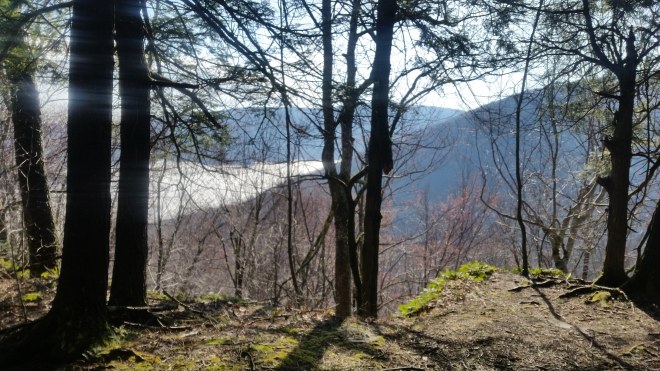
- To the southeast, the ski trails on Hunter are visible, and with binoculars I locate the firetower on top.
- Arriving at the vantage point near Bearpen’s summit, I look north at the Schoharie Reservoir, a familiar sight, and now, for the first time notice another reservoir, a broad circular pond sitting atop a hill. This is the upper reservoir of the NY Power Authority Blenheim-Gilboa Pumped Storage Project. Electricity is produced during periods of peak demand by draining water from the upper reservoir, and during other periods, water is pumped back up to recharge the facility.
- Vly is a slippery climb. I’m wearing spikes, but with fresh snow on the ground, snowshoes would’ve been a better choice. Once at the top, I grope around in the thickets of birch, cherry, and striped maple, peer through the branches into the distance, and am rewarded with views of the Southern Catskills: Wittenberg, crafty Cornell (recognizable from its toothy grin), and stern-looking Slide. To the southwest, a prominent double-topped peak stands out: aptly-named Doubletop Mountain. The next peak over looks vaguely pyramidal, and this would be Graham, and then the last in the series ought to be Balsam Lake Mountain, which has a firetower on top. I’m staring through the binoculars, and I think I’ve found the firetower, but it’s hard to be sure it’s so far away….then sunlight glints on the tower’s cabin window.
- I’ve never seen Bearpen and Vly from afar — just when driving up the valley to their base — but now I know which peaks to look from.
Balsam Lake Mountain and Graham — April 23, 2018
- Spent the night at the Mill Brook Road lean-to, woken early by birds
- Still a lot of snow in the woods, so I ditch plans to bushwhack up Balsam Lake Mountain, instead driving back to the Dry Brook trailhead
- Pleasant vigorous walk in, with the trail dry until 2800 feet or so and then soft snow that isn’t hard to walk on
- Visit Graham first, and here take a few minutes to address some irritation on the ball of my right foot. I ran a 10-K the day before in Kingston, and while I had a great time (especially seeing friends after), the run had gone very poorly. Evidently I’d gotten a splinter or particle of glass in my foot. Now I take a breath, sit down on a rock, put on reading glasses, and spend the next 30 minutes with tweezers and jack knife scissors blade working to get at a tiny fragment — too small to see, but the knife blade makes a scratching sound against it — and finally it pops out leaving a small hole behind. It was lodged in the upper layer of skin, and there’s no real damage, and with a little moleskin and a strip of tape it’s fine for the rest of the day.
- Now walking on the trail toward Balsam Lake Mountain listening to the birds: blue jays, robins, chickadees, a raven, and lots of woodpeckers cackling and knocking away (and some tree trunks have huge oblong holes with piles of wood chips on the ground). Lots of songs, but I see very little: these birds practice the art of cover and concealment
- At Balsam Lake Mountain, one of my goals is to climb the firetower and pick out Vly and Bearpen. But after venturing half-way up, my fear of heights takes over, and I crawl back down. I try again, make it up just barely above treeline, crouch on the stairs one hand holding binoculars the other clutching the chicken-wire nailed to the stairs. And there’s Bearpen! — confirmed with a compass heading, a modest-looking mountain with a long sloping summit, and its neighbor Vly which is steeper, and I can even pick out the dirt road leading up to the saddle between the two. It’s a clear sunny day without a single cloud in the sky and virtually no wind.
- While up on the firetower, I also scan the surrounding fir trees for birds, as I keep hearing a long and beautiful call issuing from somewhere in the treetops, but the singer keeps carefully hidden.
- On the walk back, more birds. Junco’s flit about, flashes of black and white, birds I associate with summits and ridges. One perches on a branch and gives a brief call, then drops and flies off low and fast. A group of chickadees flits through the trees. That mysterious song again and this time a glimpse of a small olive bird, but’s its screened by a branch, I can hardly see anything. Almost back to the car, a flash of yellow-green: a male pine warbler, and his significant other.
Sugarloaf, Twin, and Indian Head – April 23-24, 2018
- Before camping out in the Mink Hollow lean-to, I go up Sugar Loaf. There’s still a lot of snow and ice above 3,000 feet, so I step carefully.

- Mindful of these conditions, the next morning I opt to skip Plateau, a steep climb which might not be sensible without crampons (which I’d left in the car). Instead I drive over to Prediger Road and hike up to Twin….although forgetting, of course, to bring the crampons with me. However, it’s not that bad, and I make it to the top stepping carefully where the ice is slick.
- On the eastern summit of Twin, two black raptors circling overhead — vultures? ravens? — I stare through the binoculars as one of them hangs motionless in the southern wind, its head down, scanning the depths. Folding wings against body, the raptor drops like a rock, only to catch the wind again and resume a motionless posture. Then it wheels about and in a flash it’s over Twin’s western summit, a half a mile away. Now I understand why the song birds are so elusive.
- On the western summit of Twin, another raptor circling in the sky, this one off-white with mottled markings. It cocks its tail feathers, yaws to one side. Another hunter soars by, this one with black and white bands on its tail (broad-shoulder hawk I think)
- From this vantage point, I locate Bearpen and Vly once again, this time looking west. And Halcott, too, a long sweeping summit with steep slopes, like a knife had gouged out the intervening valley (which is appropriately called Deep Notch).
- On the way back down, a dark-eyed junco sitting atop a fir tree issuing a staccato series of chirps and then it drops and darts away. Another one taking a bath in a puddle. It flutters its wings vigorously, splashing water about.
- Indian Head is uneventful. I wear spikes while descending the snow and ice.
- Down in the valley, a stout little bird is hopping along on the ground: brown on back, white chest with brown marks, short beak, narrow tail, white ring around black eye — it’s a hermit thrush, the first I’ve ever seen, although I’ve heard its song so many times, including right in this spot when I was finishing the Devil’s Path Double.
Wittenberg, Cornell, and Plateau — April 28, 2018
- Spring in the Shawangunks is weirdly psychedelic: the bright yellow of forsythia bushes exploding alongside the road, the orange-brown of pitch pine needles carpeting the trail, the maple trees a strange mix of green (trunks spattered head-to-toe in common greenshield lichen) and clouds of flowering buds (bright red, maroon, or brown)….these colors are making their way into the Catskills’ lower valleys, about a week or ten days later

- Up and out the door early, as the weather forecast calls for rain later in the day
- Pulling into Woodland Valley around 7:30 AM for the climb to Wittenberg and Cornell, and shoes go in the pack for the first barefoot hike of the spring
- Ground wet from rains the night before, the trail is steep and rocky, and this is a little unpleasant, but the day’s warming up quickly and the fog is rising in Woodland Valley into a clear sky
- A conventional hiker (wearing boots) passes me. The trail levels off after a while, and I’m able to run a few steps here and there, and then settle for an aggressive uphill power-hike.
- Above 3,200 feet, patches of snow and ice appear. My feet sting and then get cold — and I worry about pushing too far and suffering damage. But I persevere, finding rocks, logs, moss beds to step on between the snowy sections. As long as I don’t have to walk more than a few steps in snow, I’m OK.
- And then I catch up to that hiker and pass him. And then pass a group of campers carrying heavy packs.
- The summit ledge of Wittenberg is sunny and free of snow….and it’s the perfect vantage to watch the exhalations of moisture from the wet forests rising into the air, rotating, stretching about — the birth of a cloud. I lay back and enjoy the sun. The other hikers arrive, and then a friend Tom D. appears. We relax and talk about the route, favorite shoes, races, mutual friends, and other important topics.

- Time to head on to Cornell, and at first I feel chilled to be back in the cool damp forest after sunning myself on the ledge, but it’s nothing that a sweater doesn’t cure.
- The short walk into the saddle is free of snow, since it has a southerly exposure, but the climb to Cornell is covered in snow and ice. However, by this point my feet have gotten used to the cold (the ability of hands and feet to warm themselves by alternating vasodilation and vasoconstriction is called “hunting reaction“). It’s a mild, sunny day, and I step across the snow and ice mostly concerned about slipping on the slick ice — especially when climbing up the notorious Cornell’s Crack, and then doubly so when descending.
- On the return, the snow and ice no longer bothers me at all, in fact it feels refreshing.


- I spot a small bird with distinctive black and white stripes on wings and chest — the aptly named black and white warbler.
- Half-way back, the long and magical song of the warbling vireo breaks out, but only once. I stand there with phone in hand, ready to record, but the bird has fallen silent.
- On some of the level parts, I jog and run a few steps, until it turns too rocky and wet (water is running down the trail in many sections), and the last mile back into Woodland Valley is steep, rocky, and difficult.
- Today was supposed to be a 24-hour fast, but I’m hungry, so change in plans: a late lunch (3:00 PM) before heading on to Plateau. Feet have had enough for one day, so trail running shoes go on.
- Rain hits on the drive over to Mink Hollow parking area. I hesitate, sitting in the car, heater running, finally grit my teeth and head out. The rain stops.
- Last fall, after some initial progress in recovering from the sore ankle tendon that had plagued me for a year, I charged up Plateau aggressively — and not only caused a flare-up in the ankle but also came back with a sore knee. This time I’ve got a different plan: a measured and steady pace, with four brief intervals (100 steps each) where I’ll push uphill more aggressively. What a runner might call “Fartlek” intervals.
- There’s some snow and ice around 3,700 feet, very close to the summit. The ice is slick, I step carefully.
- On the descent, thunder starts to crack up on the ridgeline. I’m glad to be back on the lower slopes.
- A warbling vireo calls out. I pull out phone, but it falls silent.
- The rain finally hits, but the parking area is in sight. I march stoically through the drops and dive into my car.
- Lightning ushers me out of the mountains, and heavy rain follows me on the drive home.
Running the Long Path is available on Amazon — click on the image to check it out


[…] hawk flies up from the woods. I saw one of these from the summit of Twin Mountain just the week before. Perhaps the same […]
LikeLike