Henry David Thoreau, transcendentalist philosopher and author of Walden, wrote an essay on the colors of fall foliage. But what about the colors of winter? With this question in mind, I set the alarm for 5:30 AM and went to bed early. Tomorrow’s agenda would be to climb four of the Catskill high peaks with the goal of making progress toward the Catskill 3500 Club winter patch, as well as the Grid. And perhaps I’d see or learn something along the way that would help me better appreciate the winter mountain landscape.
The next morning I was on the road before dawn, the Catskills looming in the distance but only barely perceptible against the horizon. All you could see was a faint line separating the darkened peaks from the still-dark sky.
By 7:30 AM, I’d arrived at the Mink Hollow trailhead. It was light now, but overcast, and the forest was dim — a gloomy contrast to the conditions two weeks ago, when I’d run around Hunter Mountain with the sun beaming down and energizing the landscape, a winter day that was dazzling and exhilarating. Now I was struggling to sign in at the register with a pen whose cold ink wouldn’t flow. Eventually I scratched in the four peaks I planned to climb and then activated GPS watch and personal locator beacon and strapped micro-spikes onto my trail-running shoes.
A 2.3-mile trail leads from the parking area to a saddle between Plateau and Sugarloaf Mountains. The path took me gradually uphill. It twisted over snow and rocks and criss-crossed streams, and several sections were wet or washed out.
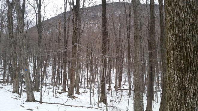
In due course, the saddle came into view, and then Sugarloaf was towering above me, looking large and stark through the barren forest. I trotted past a lean-to, spotted two sleeping bags inside, and wondered whether the inhabitants were still asleep.
Turning right at the trail junction, I started up the shoulder of Sugarloaf and within a few steps heard quiet cheeps coming from up in the trees. I paused and looked around. After a moment, a small bird with white and black stripes across its face and a dark back and white chest fluttered onto a nearby branch. A moment later, a second bird appeared, similar but with a russet-colored (light red-brown) chest . It was only four feet away. The bird stood head-down on the branch of a yellow birch tree and then pecked twice at a spot where the bark had peeled off.
John Burroughs once wrote, “You must have the bird in the heart to see it in the bush.” Six months ago, I had no idea what a nuthatch was or that there were both white- and red-breasted varieties. Now I see them everywhere. It’s as if a small flock of nuthatches were following me around, gradually becoming more comfortable with my presence, and each time appearing a little closer.
A few more steps up the trail and then off to my left the three peaks of the Blackhead range rose against the horizon, about ten miles to the north. Behind them the clouds were glowing with a faint tinge of yellow, as the sun was still low in the sky. Through a break in the clouds, clear sky shone through in a shade of light turquoise.
My attention returned to the trail: sheets of ice had flowed down and over a series of ledges creating a steep, slick incline. This was a treacherous obstacle, and a false step could result in a world of hurt. For a moment I thought about turning around and going home. After careful consideration, I placed one foot gingerly and then rotated my body until my full weight was pushing down through the teeth of the micro-spikes. They gripped, and I stepped and pulled myself to the top. I made a mental note to avoid this section on the way back.

The climb to Sugarloaf’s summit is 1,100 feet over a mile’s distance for an average grade of roughly 20%. Upon reaching the summit, I found the trail tunneling through a snow-covered forest of Balsam fir without any views, but on the hard-packed crusty surface I was able to jog along at a moderate pace. After another mile, I was running down the trail on the far side of the mountain until I landed in Pecoy Notch, the saddle between Sugarloaf and Twin Mountain. From the notch, Twin Mountain stood above me, its two peaks reminding me of a two-humped Bactrian camel.
The climb up to Twin is another 20% grade, but only 700 feet high and 0.7 mile long, and I was soon standing at the first of the two peaks, and then after navigating a relatively gentle dip, I reached the second. To the south, the sky was a murky gray. A winter storm system was moving through Tennessee and North Carolina, and evidently its influence extended all the way into New York. Strong winds were forecast for the next day, but for now it was dead calm.
From Twin I ran, jumped, and slid all the way down into Jimmy Dolan notch, and then without any pause headed up toward Indian Head’s summit. This would be the easiest climb of the day, only 500 feet or so over 1/2 a mile. On the way up, I noticed a large number of paper birch trees coated in thick ice. These trees aren’t native to the boreal or northern forest environment of the Catskill peaks because their seedlings can’t get enough light in the dense fir-spruce thickets, but they’re quick to move in when fire or blow-down disrupts the canopy. There must have been a freezing rainstorm in recent days, because the birches’ long slender branches were coated in up to an inch of clear ice and bowed almost to the ground. The smooth papery bark was covered in a thin glaze of ice which looked like varnish. Where the outer bark had peeled away, the inner layers shone through the ice with a warm russet color, much like the chest of the red-breasted nuthatch. A light breeze picked up and the ice-encased branches gently rattled against each other.
I arrived at the top of Indian Head and immediately turned about to retrace my steps. A little while later, back on Twin’s eastern summit for the second time, I paused for a little longer this time to study the view. To the south, the Shawangunk Mountains were visible as a dark gray ridge, but the two towers that mark the northern and southern endpoints of the range (Skytop in the north and the Monument at High Point State Park in the south) were masked by haze. Shifting my attention closer in, I noticed the fir trees on this open ledge were covered in snow and ice on their eastern sides, but clear on their western sides, where I surmised the ice must have melted in the afternoon sun. In any case, conditions here were not static, as I could tell from the small icicles dripping from the ends of fir branches: they were bent in the middle, presumably due to the accumulation of ice which weighed the branches further down even while the icicles were still forming.


I crossed the dip once again and arrived at the western summit of Twin. Looking west, Sugarloaf Mountain dominated the view, with long spurs running to the south and north, and past it sprawled Plateau and then just beyond the firetower on Hunter Mountain stood out. To the west-southwest, Panther Mountain caught my eye, looking like a shark’s fin with a notch in the middle. Beyond it lay Slide Mountain, the Catskill’s highest peak. To the south of Slide, Peekamoose Mountain stuck out like a small bump, while Table Mountain was long and flat just as its name implies.
Back in Pecoy Notch I ran into a group of four hikers who’d just climbed up from the north. They’d stopped to eat a snack, and I noticed that one of the young men was unwrapping a large chocolate chip cookie. I hadn’t eaten or drunk anything since the night before (except for a cup of espresso), the purpose being to train my body to burn fat efficiently without depending on constant sugary snacking. But that cookie sure looked tasty.
And now it was time to head up and over Sugarloaf once again. Near the summit, a small woodpecker with black and white wings hopped along a tree trunk. It kept its distance from me and soon vanished into the forest, flying off in the undulating pattern characteristic of its species. I think it was a hairy woodpecker, although it might have been the similar-looking downy woodpecker.
The trees along the trail were encrusted with heavy loads of snow and ice, but they seemed to bear these burdens with a stoic spirit. The top of one fir tree was bent over horizontally. Long slender birch branches drooped under the weight.


On the way down I met the two hikers who’d been camping in the Mink Hollow Lean-to. We compared notes on conditions, agreeing that the icy incline below us (which had troubled me on the way out) was the worst spot on the trail, and then wished each other safe travels.
Sugarloaf is a remarkably wet mountain, and today it was positively oozing with ice. Wooden planks on the trail near the summit keep the hiker out of a soup of black mud; now these were covered in snow, but there were a couple of spots on the trail that were wet, perhaps from underground springs? When I reached the icy incline that had troubled me in the morning, it didn’t seem quite so bad as I recalled, and I descended safely using five points of traction, that is both feet and hands and my rear end. After brushing myself off, I looked up and once again the three peaks of the Blackhead range were staring at me from the north, looking sort of baleful, as if aware of but uninterested in my movements.
The last climb of the day awaited. Plateau’s summit lay 1 mile away and 1,100 feet up from the saddle. At first the trail meandered through the forest following a contour around to the north. I spied a pair of bluejays which quickly fluttered off, and a moment later their jeering cry echoed through the woods. Then the trail turned abruptly into a steep draw and headed straight up. The slope was relentless. I dug each foot into the crusty snow, heels not even reaching the ground, and calves and quads were soon aching. I paused, heart pounding. To my left, a series of ice stalactites dripped from a ledge, some of them stained yellow with minerals or sediment that’d leached from above.

Checking the map, it appears most of the climb to Plateau is concentrated in that steep draw over a distance of one-half mile, which implies the grade is nearly 40%. Every few steps I’d look at the altitude reading on my watch, but progress was slow, and I stopped twice more to catch my breath. Eventually I made it to the top, looked around briefly at the dense fir forest, and then turned back. It would be all downhill from here, and I ran, slid, and stumbled all the way back down to the saddle, as fast as tired legs would allow.
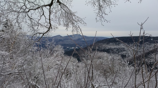
There was a final treat about halfway down Plateau: a view of Round Top and Kaaterskill High Peak about five miles to the northeast, framed by frozen branches.
Passing through Mink Hollow notch one last time, I waved to a family of hikers who’d occupied the lean-to and built a fire in the pit. A breeze picked up and whispered through a grove of young beech. A few pale, shriveled leaves still clung to the branches, shivering in the wind.
I tried running back down the path to the Mink Hollow trailhead, but my legs were too tired. The temperature dropped. The fingers of my wool gloves froze solid, and cold water seeped into my shoes. I finally made it back to the car, and later that evening celebrated the day with a nice dinner with my wife.
I had discovered a few tinges of color in the winter mountains. They were faint and subtle, and you had to look hard to find them. These four peaks bring me to 110 of the 420 ascents required to complete the Grid. I have a long way to go, and a lot more to discover.

Running the Long Path is now available on Amazon! (Click on the image to take a look)


[…] Winter hiking gave me a chance to study some of the season’s subtle hues, like the warm red bark of the paper birch once the white layers have peeled away (the same hue incidentally as the chest feathers of the red-breasted nuthatch which frequents the Catskills’ boreal forests during the winter months) or the parchment color of shriveled beech leaves still hanging from the gray branches and vibrating in a random breeze. And sometimes winter colors startle you, for example, when the clouds momentarily part to reveal a patch of brilliant electric blue. […]
LikeLike
[…] wrote about the brilliant colors of New England’s fall foliage, but I wondered, what about winter? And I found such a wild mix of impressions during my winter runs: sun dazzling against fresh […]
LikeLike
[…] much of a scramble is Sugarloaf’s western flank, although I did remember a steep spot from a winter hike, which sheets of ice had turned into a chute. This time I scrambled up the rocks, grabbing roots […]
LikeLike