With all the peaks for May complete, the Catskill Grid is on pause until the 1st of June. With some time on my hands, I was thinking the other day about the Catskills All Trails Hiking Challenge, also known as Redlining the Catskills, a project where you keep track of all your hikes and runs until you’ve covered every step of the 345 miles of official trail. On a whim, I downloaded the list and started checking off the trails I’d completed as part of the Grid and other adventures, and perhaps that was a mistake, or put differently, these projects are slippery slopes and even if they don’t sound compelling at first, once the spreadsheet is created, then you feel the force of gravity starting to tug.
With respect to the Redlining project, my calculations showed around 40% of the 345 miles complete. There are a number of connector trails and side-loops I’ve never explored, particularly out west.
With the forecast calling for a beautiful spring day, a glance at the map identified Ashokan High Point as a place I’d never been with a trail that wasn’t too long and a trailhead that was only an hour’s drive away. So Odie and I piled into the car and off we went….
I’d been to the Kanape Brook parking area once before, as part of an ill-fated attempt to climb Balsam Cap Mountain without using map, compass, or GPS. This time after parking the car I go in the opposite direction, crossing the road and heading out along a red-blazed trail and across a wooden bridge.
The first surprise is a strange-looking creature crossing the trail, four inches long and orange and speckled with black dots. Apparently this is the Northern Red Salamander, and although I’ve seen thousands of Red Efts (Eastern Newts) in the Hudson Valley and one Spotted Salamander, this is a first for me.

The day before I did some slow barefoot running on a narrow path in the Shawangunk mountains, and this morning I’m ambitious to do more running and expecting a softer surface (as the Shawangunk rocks are tough and gritty, while Catskill sandstone is smooth). But trail to Ashokan High Point is an old washed-out forest road and not only rocky, but unremittingly so, with gravel in some spots, bluestone shale fragments in others (which is smooth and easy enough to step on) but the rocks just don’t stop. I give up on running and settle for a vigorous hike. After a couple of years of barefoot hiking, the rocks aren’t painful underfoot, they’re just mentally demanding and awkward: you have to aim each foot precisely to avoid pointy, slanted, and tilting surfaces and then, if like me you’ve worn shoes most of your life, you have to remember to bend the knees to absorb the shock and then pick up your feet rather than pushing off….and every few steps, some kind of surprise, whether a rock hiding under dried leaves, a twig, or just an acorn cap — the irritations are cumulative and eventually wear you down.
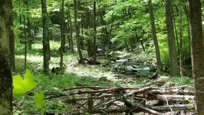
The trail follows the Kanape Brook, which is a typical Catskill stream meaning lovely cool water meandering through a narrow valley, rushing over dark stones here, pooling in a clear basin there, shaded by tall trees and dappled with sunlight.
Small violets blooming along the path, yellow, white, and purple.


Passing through a grove of hemlocks, and then finding white pine, too, I crush a few needles, enjoying the sour resiny aroma of the hemlocks and discovering that the white pine smells of resin, too, but with a smooth, subtle scent — contrasting with the Shawangunk pitch pines which have that same resin scent, but harsh and rough.
In the woods, woodpeckers cackling off in the distance, ovenbirds everywhere and possibly some black and white warblers (the songs sound similar), black-throated blue warblers (“cheep, Cheep, CHEEP!”), and then a song which is either a robin (“cheery, cheery, cheerily, cheerily”) or a red-eyed vireo (“cheerily….cheerily….cheer-cheery”). A small buff and white bird is singing on a branch, then zips up into a pine. Red-eyed vireo.
And then a weird dissonant trilling sound off in the distance. Grey tree frog? American Toad?
An open area with water seeping across the trail, and the stinging nettle which loves these conditions is growing happily. Passing an intersection, the trail heads up along a typical Catskill ridge, alternating between flat terraces and short rises, something like a wedding cake. This topography presumably reflects alternating bands of shale (which is soft and erodes quickly into clay and dirt) and the more durable sandstone. But the vegetation is reminiscent of the Shawangunks, with lots of short oak trees and an understory of Mountain Laurel, and where the trail gets some light, it’s lined with blueberry. I’d noticed similar vegetation on a trip last fall to Moon Haw on another south-facing slope in the southern Catskills; otherwise, laurel, oak, and blueberry is uncommon in the high peaks.
This morning the trees are just starting to leaf out, and the sun is strong. Odie finds some shade under a slab of sandstone.

At the top we find a small ledge with a narrow view looking south, ringed in by oak and birch. Plains stretch out below us, blue and hazy. I study the young oak leaves and flower strings unfurling from buds, but otherwise we don’t linger because of gnats and lack of shade.


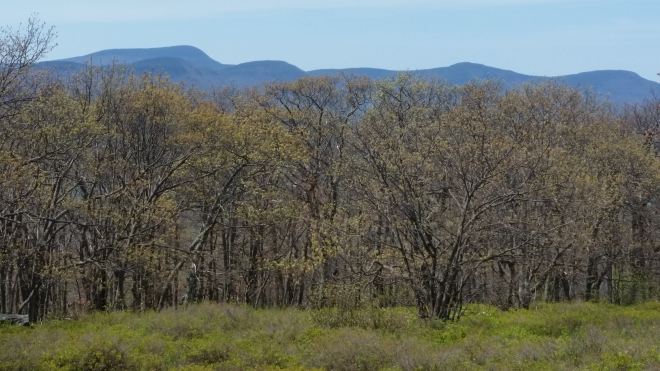
Continuing along the top of the ridge, the trail passes into an open field of grass and blueberry heath, with striking views of Wittenberg, Cornell, and Slide, as well as the pathless ridge that connects these peaks with Table and Peekamoose. Someone’s built three chairs and a firepit out of bluestone slabs, and it seems this would be a nice spot to cook out and enjoy the sunset.

The sun beats down on us. Ever resourceful, Odie finds a puddle to bathe in.

In the oak trees, more ovenbirds and now eastern towhees and a bird with a distinctive rising call, like the sound made by filling up a bottle with water, all of which I heard on a recent hike in the Shawangunks. The birds are calling from short, leafless trees right next to the trail, and I stare and stare, listening first with one ear, then the other, then with both ears and hands cupped, but see nothing. Starting to descend now, a hermit thrush sing in front of us, invisible. Besides that red-eyed vireo, I’ve seen no other bird all day.
More spring flowers, including the electric-white painted trillium and the spiky-white foam flower.


Sometimes Catskill trails are a little smoother up on top of the ridge, once you get away from the old washed-out forest roads, but the Ashokan High Point trail remains difficult all the way, and now that we’re looping around to the west on the descent, small rocks, sticks, and acorn caps are abundant. Then the trail plunges down a ravine, merges with a dry stream bed, and dissolves into piles of loose rocks. My equilibrium waivers.
Eventually the loop brings us back to the trail we first ascended, and now there are 3 miles back to the trailhead on familiar terrain. More black-throated blue warblers and red-eyed vireos, plus the eerie metallic descending cry of the veery thrush and an eastern peewee (“peeee-a-wee!”). But the rocks are starting to beat me up. It’s not painful, really, as my feet are tough enough to walk on them, it’s just aggravating — I have to keep reminding myself to use feet like hands and grip the ground, rather than punching it. But the real frustration is that having come out this morning in a mindset to move a little more quickly, now I’m finding myself slowing down, and this is beyond frustrating. Well, barefoot hiking teaches you to be humble, and it does this in part by humiliating you when you try to go fast. I begin to groan out loud with frustration — prompting Odie to come trotting back to see what’s up — and then after this goes on for a bit, I stop, clench fists, and shout “aarrrgghh!” really loud. And feel a little better.
On the way out, the frogs (or toads) are still trilling away somewhere off to the side, but the Northern Red Salamander has moved on.
We get back in the car, drive home, and check Ashokan High Point off the list. 42% of the Redline project is complete….
Running the Long Path is available on Amazon – click on the image to check it out:


Wow, you are tough hiking barefoot. Well done
LikeLiked by 1 person
Tender foot 🙂
LikeLike