In years gone by, I’d think nothing of thru-running the entire 70-mile Shawangunk Ridge Trail (SRT), most recently in 2015, when it took me around 24 hours. This year, however, still recovering from a sore ankle tendon, it would have to be a slower execution, and accordingly I drew up plans to thru-hike 40 miles of the trail over a two-day period. This is the stretch of trail I’m responsible for as a volunteer supervisor with the New York-New Jersey Trail Conference, where I work with a crew of twelve other volunteers to keep the trail marked and passable. This hike would be an opportunity to inspect conditions and see what work was needed.
The exotic beauty of the Shawangunk mountains never fails to amaze me — the gritty white conglomerate and dreamy pine barrens so different from other New York landscapes. Each trip brings fresh discoveries, and familiar sights are revealed in new ways. Here are some photos and observations. I hope they inspire you to come experience the trail for yourself….
(The Shawangunk Ridge trail connects the Appalachian Trail in High Point State Park, New Jersey, with the Wallkill Valley Rail Trail in Rosendale, New York. For thirty miles, the SRT is co-aligned with the Long Path, New York’s signature long distance trail.)
Mountain Road, Greenville, New York: 8:00 AM, May 6, 2018 — My wife drops off me and Odie the Labradoodle where the Long Path enters the woods. And we’re immediately surprised: right next to the blazes, a pile of gravel, the roar of machinery, people in hard hats, a row of large yellow excavators parked on the road leading up the hill (I count eleven of them). We saunter in trying to look nonchalant and are immediately shooed away. However, a gap in some fencing about a hundred yards to the south gets us into a field, and we hook up with the Long Path a short distance later. After a half-mile, we need to cross an access road which is evidently part of the project. I lift Odie up and over a barrier, and then we’re on the far side, and the excitement is behind us.
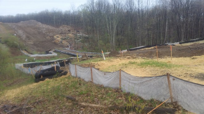
Now it’s an easy walk along an old dirt road through rolling forest and past quiet ponds. This 435-acre parcel was preserved by the Trail Conference, Open Space Institute, and other conservation partners in 2012, part of a project to create a greenway across the entire Shawangunk mountain range.

After a mile or so, the Long Path joins up with the Shawangunk Ridge Trail. From this point, the two trails run together heading north, for the next thirty miles. They initially follow another dirt road, then drop off onto a narrow forest path. I’ve missed this turn-off in the past, but there’s no excuse: it’s well marked with a pile of rocks, aqua blazes, and Long Path and Shawangunk Ridge Trail disks nailed to a tree. I give a shout for Odie, and we bank left.

The moss-lined path is easy walking after rocks and gravel on the old dirt road. Small orange newts (called red efts) have ventured out after earlier rains. Ovenbirds call out: “teacher, Teacher, TEACHER!!!”

Odie and I are strolling along, when a figure materializes on the trail: it’s our friend Steve Aaron, who’s come out to walk a few miles with us (Odie’s especially excited: he doesn’t forget people who share a peanut butter and jelly sandwich). The three of us meander along an abandoned railbed, stepping around chunky rocks and piles of gravel. The morning is cool and misty. We pause to look out toward the valley of the Neversink and then turn to admire large towers carrying the Marcy South power lines to New York. Someone’s painted Long Path blazes on these towers to keep the hiker on course (even though there’s nowhere else to go). These blazes weren’t there when I thru-ran the Long Path in 2013, one of countless improvements to the trail over the last few years.
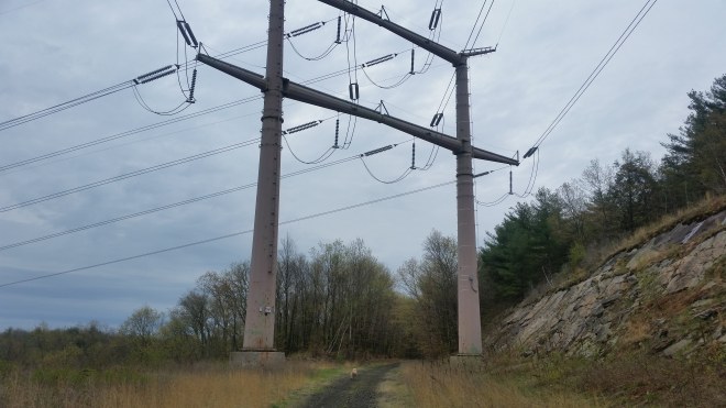

The Long Path is a strange mix: beautiful forest and mountains, but occasionally some reminders of the sprawling modern world, like the Marcy South power lines, or that construction project on Mountain Road.
Steve says goodbye and returns to his car, while Odie and I march on, in due course reaching a small hill called Gobblers Knob. We encounter a party of four descending from the ridge who are evidently surprised to see barefoot hikers. But the trail here is very soft, in fact in some places you’re walking directly on beds of moss or damp lichen. It’s also impeccably maintained and blazed.

Onwards to the Bashakill Wildlife Management Area, where the trail follows an old railroad bed along the eastern shore of a large wetlands. There’s one muddy section, but otherwise the path is in great shape. In fact it’s recently been widened and mowed, some sections are as smooth as a fairway, and I can’t resist some easy jogging. A pair of ducks flap across the path, a deer steps off to the side, starlings call from seemingly every tree, Canadian Geese honk incessantly, the path curls through a pine grove.


Now the trail is straight as an arrow, the sound of traffic grows near, we pass under route 17 and emerge in the outskirts of Wurtsboro. Walking along Main Street, there’s a new deli and health food store and a building labeled “red newt” (its purpose unclear) but the Mexican restaurant I once ate lunch at is gone. We’ve made good time and are ahead of schedule. In due course, my wife arrives to pick up Odie, for whom 20 miles is a long day.
I grab dinner at Danny’s, not having eaten anything since breakfast, and it’s drizzling when I emerge from the restaurant and walk out along Mamakating Road, keeping a close eye on the cars whizzing past and keeping as far to the shoulder as possible. The Trail Conference has purchased land to move the Long Path and Shawangunk Ridge Trail into the forest, and the re-route should start once the Department of Conservation approves the plans. I can’t wait to get off this scary road.
Heading into the forest on Wurtsboro Ridge, I see movement in the trees. A dark brown animal the size of a large raccoon and with a similar bushy tail (but without the stripes) is climbing a tree. It pauses and peers in my direction, revealing a small bear-shaped head, then retrieves something from a hole in the trunk, descends, and moves out across the forest floor with a slow bounding motion. For years I’d heard about fishers but never seen one, and so far this year I’ve seen two.
By the time I get up on the ridge, it’s raining heavily, and my clothes are getting soaked. I set up my small tent on a flat spot, using a birch branch for a center pole and staking down the sides, then unpack plastic sheets, inflatable pad, and sleeping bag. Somehow the gear functions as intended, keeping me warm and dry all night.
The next morning the birds sound off a little before 5:00 AM. Robins, sparrows, jays, ovenbirds, and now Eastern Towhees, large sparrows with bright black and russet colors and a loud call. A cup of tea serves for breakfast.
Moving out along the ridge, my breath visible, the valley to the west full of fog, the ground uncomfortably cold and wet under foot, but the sun rising in a clear sky. An ovenbird lands on the branch of a pitch pine, stares at me with a black eye ringed in white, its back a dusky olive color.

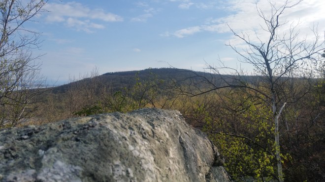
On the way down into the Roosa Gap, the glacial erratic which I joking refer to as Steve’s Rock: I told him it will be his rock so long as he maintains the one-mile stretch of trail on which it rests (but he can’t take it with him). Across the gap, two antenna installations and a fire tower visible atop of the ridge.
The trail descends into the gap and then rises steeply up the ridge and then drops again into a a shaded valley criss-crossed with old stone walls. Black and white warblers are flitting through the woods. A couple of years ago a wildfire swept through this area, and dead and dying trees have been falling across the trail. Earlier this year a Trail Conference chain sawyer named Andrew Seirup came through and cleaned up a large quantity of deadfall. Since then, a few more trees have toppled over, but we should be able to take care of these with hand tools.

The pitch pine are stubborn trees and accustomed to fire, in fact, their cones are considered “serotinous,” meaning flames are necessary to loosen the resin and disperse the seeds. On past visits here I’ve noticed individuals that were charred from head to foot, but still hanging on, sending out fresh green needles from branches, trunks, and even exposed roots. On this trip, there’s a casualty: a tree standing tall with commanding stature and widespread arms, but it’s clearly given up the ghost, bark now black and grey and dotted with holes.
But there’s plenty of vegetation in bloom: Shadbush trees sprouting white petal clusters, blueberries galore, ferns beginning to unroll, and the pale red leaves and flowers of scrub oak, another hardy species that’s quick to recolonize burned-out areas. Scrub oak is a chore for volunteers. It’s tough stems take quite a hacking. Venture off the path and you’ll get scratched up.


The trail rolls off the western side of the ridge and then turns north again, following an abandoned road called “Old Plank” by the locals. I remember running through here once upon a time and how the chunky rocks and gravel hurt my feet through thin trail-running shoes. Today, my feet are ready for a break: I put on Vibram Five Fingers and take my time. Even though there’s nowhere else to go, Long Path blazes are painted on the trees, just so the thru-hiker or trail runner knows they’re still on course. These weren’t here in 2013. I’m curious who put them up.
Once across Route 52 I go back to barefoot for the climb up South Gully Trail, pausing to admire the stream cascading over sandstone ledges. I’m getting thirsty, but don’t want to stop to filter.

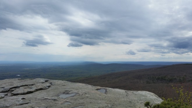
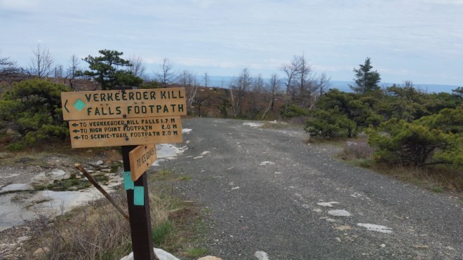
Upon reaching the gravelly carriage road up top, the feet have had enough for today and the Vibrams go back on for the rest of the hike. I stop at the visitor’s center and fill up a small water bottle and drink and drink from the water fountain and then drink some more. And then it’s off to Verkeerderkill Falls, first pausing to admire views south, where the Shawangunk Mountains snake off into the distance: 40 or 45 miles away the Memorial Tower at High Point State Park in New Jersey stands out, a needle on the horizon, marking the southern terminus of the Shawangunk Mountains and the junction between the Shawangunk Ridge Trail and the Appalachian Trail.
The turn-off toward Verkeerderkill Falls is well-marked, in another area that’s seen recent fire damage. It’s a rough trail, which in the past I’ve seen turn into a raging torrent of rain and snow melt, but evidently some work’s been done since I was out here last: there’s better drainage, big rocks moved around to create a level path, and even a set of stone steps in one place. This is the work of the Long Distance Trail Crew, a team of some of the Trail Conference’s most dedicated and skilled volunteers and passionate trail builders.


Not having eaten anything since dinner the night before, I can’t help stopping every few yards and munching on the Wintergreen berries, which are growing abundantly along the trail. They have a mild spearmint taste.


Descending through a grove of river birch, channels flowing beneath tall hemlocks, water flashing in the late afternoon sun as it pours over the edge. Seventeen miles done, sore ankle starting to twinge, five or six to go.

Now following the trail across scratchy conglomerate rock slabs, through piles of prickly pine needles, on sagging boards above black water and mud, through a rhododendron tunnel, over a fallen hemlock. Where the trail jogs south, a final view of the Monument Tower 45 or 50 miles away. A little while later, saying goodbye to the Shawangunk Ridge Trail and turning down into the valley. A stout porcupine, black with long yellow-tipped quills, cocks his head and glances at me out of the corner of one eye. Frogs peeping by a pond. Shadows lengthen. A deer moves out. Wood thrush singing their vespers.
And finally home.
Running the Long Path is available on Amazon – click on the image to check it out:


[…] rising call, like the sound made by filling up a bottle with water, all of which I heard on a recent hike in the Shawangunks. The birds are calling from short, leafless trees right next to the trail, and I stare and […]
LikeLike