“There’s no rush.” Wise people counsel patience when I explain I’m trying to complete the Grid for the Catskill High Peaks, an obscure project that entails climbing the thirty-five peaks in each calendar month. But the project is important to me, and I feel a sense of urgency to get it done.
February has been weighing on my mind. To start with, it’s a month of challenging conditions — and not surprisingly, my log shows I’ve tended to steer clear of the Catskills during February: only fifteen of the high peaks are complete, which means there are twenty to go. That would be a lot for a full month, but with a trip to New Zealand scheduled for the first half of February, those twenty peaks will need to be climbed when I return, that is, within a two-week period, of which, after subtracting various commitments and appointments, only a handful of days is available.
Some nights I lie awake, reviewing different approaches for each of the twenty peaks, trying to devise the most efficient routes to get them done in the available time. Be safe, I remind myself, it’d be fine to finish off February next year — but then I go back to calculating how to pull this off — and wondering whether I have the strength to do so — and feeling vaguely uneasy.
And now the plane from New Zealand is touching down at JFK, and here I am back in New York…
February 17 — Three days after landing, I pull into the trailhead for Windham High Peak. My friend Amy is about to complete her winter Catskill series and has invited a group to join her on an easy jaunt up Windham, the last mountain on her list. It’s a mild day, with temperatures in the low 40s, and the trail is dry. The group’s in high spirits. At the summit, we’re treated to champagne and chocolate, while Amy is pelted with rubber chickens.
It’s been a fun day, notwithstanding a twinge or two out of my sore left ankle. It’s hardly worth saying this, but with one down, there are nineteen to go.
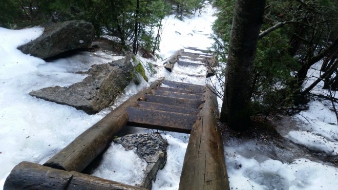
February 19 — Time to get serious: I’m going to knock off the four eastern peaks of the Devil’s Path, a trail that’s noted for steep, rocky scrambles.
I arrive at Mink Hollow the evening before and hike in to the lean-to, positioning myself for an early start the next morning. But I wake up shivering, despite a sleeping bag rated to -20 F, and feeling hungry and lethargic. Maybe I’m still jet-lagged from New Zealand, and maybe I should have brought some breakfast, although going 24 hours without food is standard operating procedure for me.
Nonetheless, I buckle on crampons and drag myself up and down the steep trail to Plateau. Next up is Sugar Loaf, an especially wet mountain which oozes moisture during the summer, and today the trail passes by fangs of ice hanging from cliffs and then disappears under large white tongues that loll out from among the rocks.
The crampons do their job, and I make it to the top without any slips. But I’m too tired and hungry to go on. The mission is aborted, only half-complete, and there are still seventeen peaks to go.
February 20 — Thinking a change in strategy might be appropriate, I get a big breakfast the next morning — a fortuitous decision because I run into friends in the restaurant. Time with them is well spent, but it’s past 11:00 AM when I finally arrive at the trailhead for Slide Mountain.
It’s a beautiful sunny morning and unseasonably warm, with temperatures forecast to reach nearly 60 F, but the trail is still covered in ice, so plans to hike barefoot are ditched and instead I march up to the top in boots and spikes. Since I’m feeling pretty good, why not go on to Cornell and possibly Wittenberg?
Yet some caution is appropriate, since the backside of Slide is very steep, and due to the northern exposure it’s quite icy. I take a few tentative steps and even with crampons it’s a little questionable, and I’m thinking it’d be OK to turn back and call it a day. But I make it down the snow-covered ladders bolted to the mountain and then reaching the dicey scramble at the bottom of the slope find a work-around through the woods where there are small trees to hang onto.
Now I’m strolling along a level path on the way to Cornell, meltwater streaming down the ice-coated rocks, and then lowering myself through the infamous Cornell Crack.


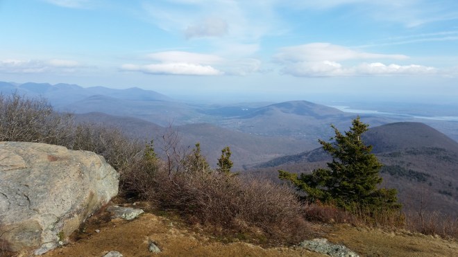
It’s become a glorious afternoon, as nice as any summer day. Reaching the summit of Wittenberg, I stretch out on bare rocks which have been baking in the sun. The Ashokan Reservoir spreads out below me, still glazed over with ice, and a row of smooth-edged lenticular clouds has formed on the leeward side of the mountains. But the watch shows it’s getting late.
The return trip is uneventful. Reaching Slide’s summit once again, I look out to the north: the firetower on Tremper Mountain glints in the late afternoon sun, behind it the peaks along the Devil’s Path are glowing warm brown, and further north Black Dome appears through a notch in the ridge.

On the final descent from Slide, it seems like much of the ice has melted, but what’s left is reflecting the orange light as I march straight into the sinking sun.

February 22, 2018 — A day off for ankles and knees, and now it’s time to go back and finish up the eastern Devil’s Path. The day is gray, but not too cold with temperatures in the low 30s and a dusting of snow on the ground. After parking on Prediger Road, I head out purposefully, feeling pretty steady — until I look up and realize I’ve missed an intersection. This oversight elicits a burst of rage and then a feeling of melancholy, as if the mistake was proof of my incompetence and an explanation for so many disappointments in life. My ineptitude is boundless: a shortcut through the woods that goes on forever, a slip and stumble on the ice, a shoelace that comes untied — each of these mishaps calling forth vexation and then sorrow. I drag along, mood alternating between frustration and resignation.
It’s snowing steadily. I put on spikes, but they squeeze my toes, so I take one off and walk along with one shoe spiked and one shoe bare. In some places the trail is dry, in some places there is 1/2″ of snow. Sometimes the spikes bite through the snow into soft gray ice, partially melted, and sometimes they skid off white ice, hard and slick. As the trail to Twin’s summit steepens, I switch to crampons. Arriving at the summit, I peer into formless gray, and the view is the same on Indian Head.
It’s snowing harder on the way back. An inch or two has accumulated, concealing the puddles that dot the trail, and shoes and socks are soaked through by the time I regain the car.
On the drive out, a dark gray layer covers the mountains, but in one spot there’s a hole in the clouds and a patch of dim gray-blue sky appears. Gray can be beautiful, too, I reflect and feel a faint smile rising from within.
February 24 — Yesterday I drove into the city to pick up Odie the family Labradoodle, as my wife is flying off to visit her parents. This morning we’re up early, and Odie senses we’re off for a hike: he’s barking with excitement and running in circles.
Rain and snow yesterday, unseasonably warm temperatures again today. On the drive north, the Catskill peaks rise above valleys smothered in fog, and then the car tops a rise and plunges into twilight, oncoming headlights shrinking to pin-pricks. But when we stop for breakfast, the sun breaks through and the temperature soars into the 40s. I look up from my plate and the scene is exhilarating.
The trail leading to Balsam Mountain is dry, so I head out barefoot, boots tied to pack, but by the time we reach the saddle, there’s an inch of slush, and the sun’s disappeared. It’s too painful: boots go on and then spikes, too.
We cross paths with a young man named Dakota who’s tells us he’d like to do Balsam, Eagle, Big Indian, and Fir. This is more than I was planning, but as I mull over the route, it seems like a good way to get a head of the curve — after all, there are still twelve peaks to go, and time is running out.
A little while later we catch up to Dakota again. He’d still like to do those four peaks, but his determination is wavering: he doesn’t have experience bushwhacking in the Catskills or the right navigational gear. We decide to join forces.
Dakota, Odie, and I crunch along through the slushy snow, sometimes talking, sometimes silent. Familiar landmarks pass by: Big Indian’s summit, the saddle between Big Indian and Fir, the tangled wall of trees near Fir’s summit, where we’re pelted with freezing rain, and then the steep descent into Burnham Hollow. It ends up 14 miles, a long day, but an accomplishment for all three of us, and a lovely hike through quiet gray forests.
And then there were eight….

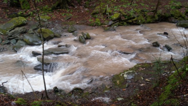
February 25 — Mid-30s and rain, perfect conditions for hypothermia, and I wake up with a feeling of dread. The new standard practice: a big breakfast, and an extra side of sausage for Odie. A little while later we’re pulling into the Seager trailhead and walking along the Dry Brook which is roaring with run-off and meltwater. The trail crosses a tributory where I have to haul Odie across on his leash through the rushing, brown, turbulent, calf-deep water.
The Dry Brook
We discover an unmarked footpath leading due south toward Doubletop’s summit. It rises steeply through a grove of hemlocks, and then the slope moderates and it’s a long walk through beech and birch. At about 3,000 feet snow starts to cover the ground, and by 3,400 feet, the snow has turned into a crusty glaze, and the path is slick and iced over. I’ve got spikes but wish I’d brought crampons.
Frozen rain patters in the forest. Tree branches are encased in ice, and fragments of these casings litter the ground. The winds are gusting overhead forcefully: like dogs herding sheep, they must be nudging this weather system along, making room for the next front. We make our way through the frozen boreal zone, sign in at the canister, and start back, stepping carefully where the trail is steep and icy. A little lower down and it’s back to a steady walk in the woods, and drifting slightly off-course we discover a magical hemlock-sheltered rocky shelf. Once below the snow, I go barefoot for the last mile and a half. When we reach the water-crossing, Odie picks his way across on a log and then makes a big jump for the far side, while I slip and fall in the water. Once I get over the shock, I can’t help but laugh.
We have a second peak planned for today, and arriving at the parking area on Spruceton Road, we find the trail to Westkill deep in slush from the start. I’m still barefoot, but I hustle along energetically and feet don’t feel too cold. We charge uphill until the ice becomes crusty and sharp (indeed, I find a small cut on one foot and am startled by a drop of blood in the snow). It’s time for shoes and crampons.


The mist turns to rain. Odie looks bedraggled, his expression seems mournful, and soon he’s lagging behind. Back-to-back days may be too much for him. I help him up some of the larger ledges, praise him when he jumps up on his own, and to encourage him further I glance at my watch and call out 0.88 miles to go, figuring he’ll appreciate the tone of my voice, if not the meaning of the digits. We move along slowly. This is turning into an endless slog. After a very long time, I call out 0.84 miles to go.
But eventually we reach the summit and starting plodding back, at least it’s all downhill from here. About a mile from the car, Odie recognizes a bridge across the Westkill stream and charges ahead. That evening he’s too tired to eat, despite the roast beef and chicken I share from my dinner, but the next morning he wolfs it down.

February 28 — Odie’s back in the city, and now here it is the last day of the month, and I’m going to climb six peaks, five of which are bushwhacks situated on a pathless ridgeline with some of the thickest vegetation in the Catskills. I wake up feeling anxious, but it’s going to be another beautiful day, sunny and unseasonably warm — a spectacular day and thrilling to be outside.
To shorten the route, I’ve arranged for Smiley’s Taxi to pick me up at at the base of Peekamoose and drop me off on Moon Haw road, making this a one-way trip instead of a circuit.
There’s no trailhead at Moon Haw, just a parking spot, but an old woods road leads up the valley, and soon I’m cutting uphill to get onto the ridge. The forest floor is dry, so shoes come off, and after a bit I’m passing a small cabin situated on a knoll and then it’s into a tangle of saplings.
I follow the crest of the ridge, an easy walk through leafless forest, the sky visible in all directions, but nearing 3,000 feet in elevation, the ridge suddenly narrows and steepens, and a set of cliffs thrusts up in front of me like the bow of a large ship. But there are routes between the slabs, and I climb and crawl upwards onto a rocky point that juts out into space. Cornell and Wittenberg roll off to the northeast, round and hump-shaped, like a pair of standing waves, while to the southeast the Ashokan Reservoir sprawls about, dozing under a blue sky, shimmering aquamarine, vaguely reminiscent of the turquoise glacial lakes I’d seen in New Zealand.


The last thousand feet to the summit are steep, and now there are pockets of snow and ice, so shoes go back on and then crampons, too. In due course, I’m standing on Friday’s summit and then studying my next objective, Balsam Cap, where the the eastern face is quite sheer, but the broad northern slope is covered in lush forest. This mountain has a reputation as a difficult bushwhack due to the devilish fir-spruce thickets.

On the way down toward the saddle between Friday and Balsam Cap, a line of cliffs forces a brief detour to the west, but after that it appears I’ve stumbled onto a faint social trail skirting the mountain’s eastern face — there’s nothing obvious, no footprints or beaten path, just enough room to slip between trees — but it’s surprising how easily I’m moving through the dense forest and then up an easy slope and straight to the summit.
The next mountain is Rocky, and once again a line of cliffs forces a detour to the west. The backside of Rocky must have seen violent winds at some point in the past, because thickets of saplings rise from among a tangle of large trunks moldering on the ground. It’s like stepping through the skeletons of dinosaurs or mammoths. Off to the northwest, the summit of Slide Mountain, the Catskill’s highest peak, peers in through a clearing.
Lone is familiar territory, and now there are footprints in the snow, and soon I’m up on top of Table Mountain, back on a blazed trail for the first time today. The forests must have been doused with freezing rain and then shaken violently by the winds, because the ground is littered with crushed ice.

From Table Mountain to Peekamoose is a short distance along the trail, and that completes the Grid for February. All that’s left now is a four-mile downhill trek to the trailhead and my car. At some point during the day, a low cloud ceiling moved in, but a golden glow breaks through to the southwest, flanked by drifting tendrils of rain. Below 3,000 feet the path is dry, shoes come off again, and I pad along feeling the dry leaves, soft dirt and rounded stones underfoot. Three times a sprinkle of rain blows through and ceases. To the front, a small triangle of golden-orange light appears between a distant ridge and the cloud ceiling, and after a little while it’s dark. Behind me the full moon is shining through the mist.

Thinking back on February (now that it’s March), what comes to mind is the simple joy of walking down Peekamoose without shoes on that strangely warm afternoon, and perhaps that was the reward for the aggravation of ice and snow and the anxiety of taking on a lot of peaks in a difficult month.
March is off to a rough start with a major nor’easter dumping snow in the Catskills and pummeling the forests with high winds. A more manageable sixteen peaks need to be climbed this month, and there is more time available, but to say I’m unenthusiastic about facing a final round of snow and ice, that would be an understatement — especially today, as snow is falling once again.
But then something unusual happens — a flicker of light, and then a crack of thunder rolls through the sky — and perhaps, I reflect, March in the Catskills will come with some surprises, too.
Running the Long Path is available on Amazon (Click on the image to check it out)

A noble effort in knocking off your remaining February peaks in just two weeks. I can’t can’t believe you did ANY of it shoeless. Anyway, good work, and kudos to Odie for his effort as well.
LikeLiked by 1 person
Thanks Todd. Payback time now, with knee-deep snow on my latest hike!
LikeLike
[…] in, but the trend is obscured by enormous variability, such as that surprising warm spell in February, which was followed by four snowstorms in March. A wave of warmth is poised to break upon the […]
LikeLike
[…] growing inches apart. I keep veering south, looking for the route I’d taken when here in February, but no luck. On the way back from Rocky, however, the mountain spirits must have smiled, because […]
LikeLike