One of New Zealand’s nine “Great Walks,” the Routeburn Track is famous for spectacular mountain scenery, alpine grasslands, glacier-fed lakes, rivers, and waterfalls, and southern beech forests teeming with native birds. The Routeburn Track was to be the final hike during my two-week visit to this beautiful country, and I was of course very excited to get started, but I’d botched the planning process. If I was to get this Great Walk done, a creative approach would be necessary…
There were two problems with my plans. First, I’d planned to cover 18 or 19 miles per day, despite a sore ankle tendon. But as shown by my painful experience on the Kepler Track, this was too much. Second, I’d gotten the eastern and western trailheads mixed up and planned my route backwards. And now, since this is such a popular track, there might not be any spaces left at the huts or campsites.
But luck was with me, for when I showed up at the Department of Conservation visitor center, there was a single spot left at the Lake McKenzie Hut in three days time. A clever idea occurred: I’d split the Routeburn Track in two. First I’d visit the western trailhead and do an out-and-back day hike on this side of the track. Then I’d drive around to the eastern side, hike in a reasonable 12 miles to Lake McKenzie, spend the night in the hut, and then hike back out the next day.
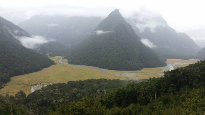
There are a few tweaks and last-minute changes, and then the plan is set, and I’m in motion, driving north from the tourist village of Te Anau toward the Routeburn’s western trailhead, following a winding road, deeper and deeper into the valley of the Holleyford River. An enormous field of tawny grass covers the flat valley floor, which is flanked by steep ridgelines on either side (the Darran Mountains on the left and the Humboldt Mountains on the right).

The trailhead is clearly marked, and a few minutes later the path is taking me up along the side of the mountain and into beech forest. Some of New Zealand’s native birds — robins, tomtits, riflemen, fantails — call out from nearby branches or hop along the trail in search of insects kicked up by passing hikers.
The Routeburn Track is smooth and well-drained, but covered with plenty of gravel, and in some places where it’s cut into the side of the mountain, the pathway crosses over jagged rock. So I keep my sandals on, but even so, my pace is pretty slow.
About five miles in, the path reaches the Earland Falls. Water is flowing over the top of a steep cliff more than 500 feet above the trail. Then it pours out into the air and dissolves into mist — before impacting the rocks farther down, splitting into two streams, and finally pooling in a basin that is so crystal-clear you can see every rock on the bottom.


A little past the falls, I call it a day. I’ve covered roughly a third of the track on the western side, and now it’s time to retrace my steps back to the trailhead. Total distance covered: around 11 miles. Sore ankle: OK. So far, so good.
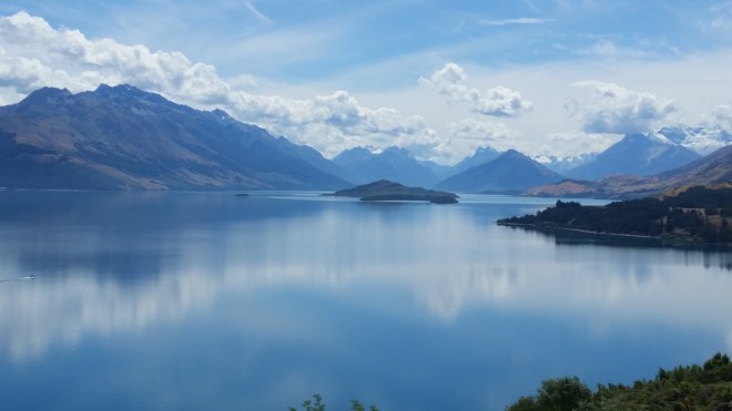
The next day is taken up with the long drive down and around the southern corner of the Humboldt mountains, eventually turning north and entering Queenstown, a resort town situated on the shores of Lake Wakatipu, one of New Zealand’s glacial-fed mountain lakes that shimmer in a remarkable shade of turquoise. The drive takes over three hours, but it’s a wonderful summer day: clear, hot, and dry.

New Zealand has done a very professional job marketing itself to the international tourism industry. During the summer, Queenstown’s resident population of 15,000 swells to half a million. The town is immaculate, lined with high-end restaurants and shops, and the public toilets are the fanciest I’ve ever seen: the door opens upon the push of a button and then an electronic voice instructs you, “the toilet will flush automatically when you activate the hand-drier or vacate the unit.”
I check in at the visitor center to confirm my reservation at the Lake McKenzie hut, buy food for the next two days, eat lunch, and then lay out in a park by the harbor, listening to a small band playing popular music. After a total elapsed time of four hours, I’ve had enough of Queenstown and am back on the road, following Lake Wakatipu north toward the Routeburn’s eastern trailhead and a nearby campsite where I’ll spend the night.
Spending the night in Queenstown would no doubt have been expensive, assuming I could find anything at all, but there’s plenty of room at the Lake Sylvan campsite, and the cost is only $13. My small tent takes five minutes to set up, and then there’s not much to do but wait until dinner. I make a cup of tea, sit back, and study the clouds.
There are some large bees whirring about the campsite, and one whizzes past my face so close I can feel the breeze from its beating wings on my cheek. Evidently curious about my GPS watch, the bee circles back and inspects the shiny silver buttons for a minute or two. Another bee is exploring the latch on the car’s hatchback, which I notice just as I’m reaching to open it. After a little while the bees lose interest in me and go back to their main business, which is gathering nectar from the purple clover flowers sprouting in the neatly mowed grass. While I return to my main business, which is contemplating the cloudscape.
To the south, an ominous murky layer hangs over the valley, and the plains are cast in shadow. To the north a thin white veil is reaching slowly out from behind the mountains and stretching across the sky, as if to totally close out the sun. And no surprise here: the forecast calls for rain tomorrow. But a little while later the sky above me starts to clear. A small lenticular cloud, round and smooth, materializes over a far ridge. Long white brush strokes are running east to west, in some places shot through with dabs and puffs. All of this somehow the work of westerly winds flowing over the coastal mountains and churning up the atmosphere into a mix of stationary and moving waves.


The next morning I wake up to light rain and a soggy tent but somehow the sleeping bag is still dry. Breakfast consists of a handful of nuts. By the time I reach the trailhead, the rain has lifted.
The track starts across a suspension bridge, and over the next hour I cross three more bridges over the Routeburn River and tributories. As the trail heads up into a steep valley, the river disappears from sight, but can be heard crashing down below in a deep gorge choked with giant stone blocks. Then there’s a glimpse of turquoise water pooling in a basin down below.

A few miles later, the valley opens onto a large grassy flatland, and the trail rises higher into the mountains. Down below a stream curls around the base of a large mountain cone, covered head-to-toe in beech forest, and remarkably steep and symmetrical.
Similar to the western side of the track, the pathway here is covered in gravel and in some places cut into the ragged stones of the mountain. Going barefoot doesn’t seem like much fun, but how would you expect to toughen up your feet and get better, if you didn’t practice on the rocky sections? Sometimes you just have to go for it — and if you place each step carefully and go slowly enough, walking barefoot on a rocky path is a manageable experience, albeit somewhat aggravating. I set a goal of making it up to the saddle, which is the high point on the track, before putting sandals back on.
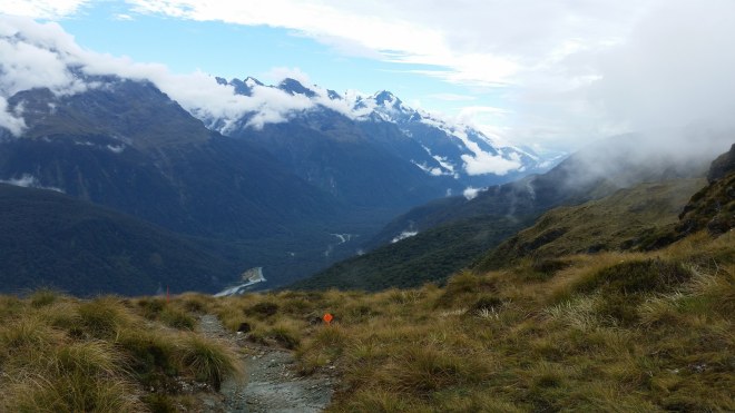
Progress is slow. The clouds get thicker, and the rain returns. I’ve passed two huts and a waterfall and should be approaching a lake near the saddle — when through the mists I catch sight of smooth dark water. This is Harris Lake — and that’s enough barefoot hiking for one day.

On the far side of the saddle, the weather clears a little, there’s a slice of blue sky, and the Darran Mountains break out from the clouds in bands of black and white. Down below is the Holleyford River. Far to the north the valley opens up, and a large body of water is visible — possibly the Tasman Sea.
The mountainscape is grand and impressive, and the eye seems naturally drawn to the rugged slopes in search of a route up and over. But I’m not going to stray off the track today, and the mountains fade into the background, as my focus returns to the rocky path in front of me and the interesting alpine plants on either side.

Three or four miles to the hut at Lake McKenzie. Even with sandals on, the rocky trail is slow-going and getting tedious. Finally, one more ridge to crest, and then down below in a valley lies a large lake, deep milky gray-green, and on the far side a handful of buildings.

There’s one empty bunk left, which is mine, and after dumping gear, I go hang out in the kitchen area. There are hikers here from all over the world, and it’s a friendly crowd. The hut warden explains that the wooden boxes we’ve seen every 100 meters along the trail are traps to catch rats and stoats, which are not native to New Zealand and now threaten the native bird population. It’s a massive project, with some 5,000 of these traps deployed along the trail, and contractors out every 5 weeks servicing them, but the birds seem to be making a comeback.
Settling into my bunk that evening, I’m pleased with the day’s work: Twelve rocky miles are done, and even better the ankle seems OK. Except for a small gap between Lake McKenzie and Earland Falls, I’ve pretty much completed the Routeburn Track. But tomorrow I’ve got to get out. That means twelve rocky miles back to the eastern trailhead, and hopefully the sore ankle is up to this task.
I’m up at the crack of dawn, no breakfast, just a cup of tea. The plan is to start out barefoot, with the specific purpose of keeping the pace slow and the ankle happy. But my feet are tender from yesterday’s rocks, so I wrap the balls of my feet with some tape.
It’s cold this morning, with a chilly wind blowing in from the north. The trail lies along the western face of the ridge, so the sunlight is long in reaching me — but when it finally does, what joy to feel its warmth!
This time around, Harris Lake is fully visible, a splendid pool of dark blue water glimmering in the sun, surrounded by jagged mountain walls.

Five miles done. The tape protecting my feet has been pretty well chewed up by this point, and while my feet are OK, that’s enough barefoot for today. I head off in sandals and suddenly realize how thin they are; I might be better served with a thicker sole designed for trails.

Now it’s all about keeping it together, staying steady, and making it back to the car with the ankle in good shape. But it’s hard not to be frustrated when a trail runner passes me, or young hikers carrying huge packs. There are three miles to go when I’m overtaken by a group of older tourists some of whom are a little stout, and I growl to myself with displeasure — but eventually I reach the end.
On the drive out, clouds of dust are hanging over the valley. A northern wind has come swooping down off the mountain and is kicking up silt from the river flats. I stop in the village of Glenorchy, situated at the northern edge of Lake Wakatipu, walk a few steps along the sandy beach and look out on gray-green translucent waters.
Time for the long drive back to Christchurch. Half-way there I pass Lake Pukaki, shimmering an extraordinary shade of turquoise, a phantasmagorical scene straight out of a fantasy landscape. The sky is a more familiar robin egg blue, pretty much the same as the sky over New York, the color of joyous, carefree summer days no matter where you are. And crossing the sky from east to west are long white brush strokes, with milky dabs and swirls around the edges – a masterpiece created by the winds as they cruise across the mountains — or a narrative account of the interactions between pressure, temperature, and moisture. I wish I could better read the signs.
Running the Long Path is available on Amazon (Click on the image to check it out)

[…] hiking on New Zealand’s Kepler and Routeburn […]
LikeLike
[…] New Zealand, I sipped a cup of tea while admiring an almond-shaped lenticular cloud that had formed above a […]
LikeLike