Random notes from January hikes….
January 7, 2018
- The conventional route to Southwest Hunter follows an unofficial trail which was cleared a few years ago, but last fall I noticed a knife-edged ridge leading to the summit that rises up from the depths of the narrow, shaded Stoney Clove notch. And of course, I’d been wanting to give this new route a try.
- The conventional trail is classified as a bushwhack, but it’s very straightforward. It follows an old horse-drawn railway bed which was used to take lumber off the mountain roughly a hundred years ago, and while the trail is unofficial and thus unblazed, it’s clear of vegetation, easy to follow, and clearly indicated on Trail Conference maps. In any case, I’d already taken this route at least eight (8) different times, so a new route to the top was an interesting prospect.
- I’d found other knife-edged ridges to be spectacular experiences (for example, I’ve followed such ridges to the summits of Slide, Sugarloaf, and Sherrill Mountains). Depending on the time of year, they may offer expansive vistas to either side, whereas down in the valleys, you see only the thick forest. Also, it’s typically easier to walk on the crest of the ridge, whether the ridge is 50 yards wide or just 5, because the footing is usually pretty level. Whereas trying to navigate the steep, slanted slopes to the sides of the ridge can be extremely difficult, not to mention painful on ankles and knees.

- I met my friend Alan for breakfast and then we spotted one car at the end of our planned excursion and parked the other about a mile from the base of the ridge, which was the closest available parking spot. The car thermometer showed -1 F, the sun had not yet reached the valley floor, and as we walked down the road, I was feeling rather cold, despite wearing wool, fleece, and goretex.
- Once we reached the base of the ridge, however, it was only a few steps uphill before we reached the morning sun, and this — plus the exertion of climbing — quickly warmed us up.
- The bushwhack along this ridge would be 2 miles long, with 2,000 feet to climb — a lot of work in snowshoes and untracked snow — but the grade averages only 20%, which meant that for the most part, we’d be walking along a moderate uphill slope. What makes this ridge so dramatic are the steep fall-offs on either side, the climb itself isn’t that demanding.
- Because of the southern exposure, the snow wasn’t as deep as I’d experienced on my last hike (an eastern exposure). Using my trekking pole as a gauge, I measured 1-8″ of snow. In some places deer had bedded down for the night, and here the snow was melted away exposing oak and beech leaves on the forest floor.
- The walking was good, although like anywhere else in the Catskills, there were plenty of young beech. What makes the beech a little annoying is that the branches grow out at right angles from the trunk, and are thus perfectly positioned to block your path. Most of the time you just push them out of the way, but on occasion you’re looking down at where to step, and one smacks you across the forehead.
- On my last hike, I’d studied the buds of the striped maple, which occur on long red branches, with one bud at the tip of the branch, and two further back pointing out to the sides. So of course today, wherever I looked, there were forests of striped maple saplings crying out for me to admire their buds. However, since their branches tend to grow upwards at a 45 degree angle, they’re easier to slip past than the beech branches. Oak, ash, and hornbeam were also present, as well as the ubiquitous yellow birch and some black cherry trees.
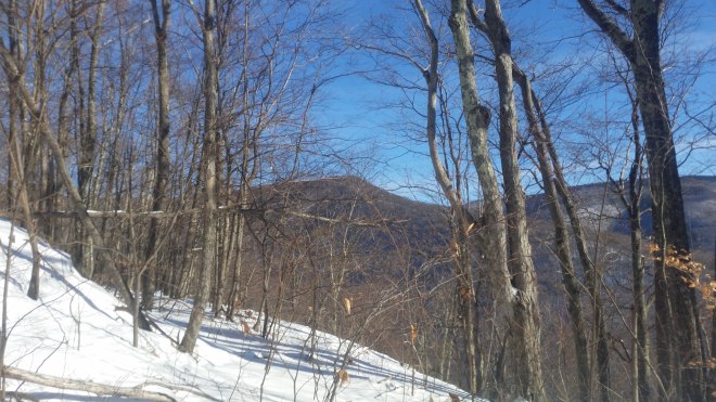
- As we gained in altitude, we were indeed treated to delightful views. To the south, stood Slide Mountain and Panther, the southern bulwarks of the Catskill Mountains, shimmering against a clear sky. To the north, a long ridge capped in fir-spruce indicated the shoulder of Hunter Mountain, and the ridge swung a long way around to Southwest Hunter, which we couldn’t quite see. On either side the slopes dropped off into very steep draws, the one on the right containing Myrtle Brook. Back in the day, lumber harvested from the top of the mountain was transported on a cable tramway down to a sawmill and railway depot located on the valley floor below.

- As we rose in elevation, the snow deepened to around 9-15″. Alan led the way, breaking a fresh trail in the untracked snow, while I lagged behind, mindful of ankles and knees, and pausing from time to time to strip off goretex, fleece, and hats to keep from overheating.
- In due course, we reached the boreal zone, which was indicated at first by some hobblebush and a few young spruce. Soon enough we were weaving among taller and more mature conifers, including balsam fir and red spruce, and now the views were masked, but there was plenty of blue sky above and patches of sunlight reaching into the forest.
- The fir-spruce began to get very thick, and the branches were covered with several inches of snow. The smart move is to shake them off before you squeeze between, but even so, within a few minutes we had gotten plenty of snow dumped on our heads and down the back of our necks. I had to take off my sunglasses, they were so thickly covered with snow I couldn’t see out.
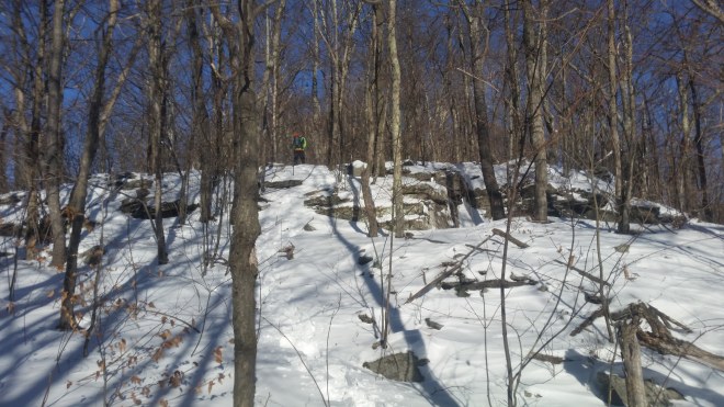
- So far, it hadn’t been necessary to pull out a compass or refer to GPS. One of the nice things about a narrow ridge is that if you just follow it uphill, it will eventually lead you straight to the summit.
- But as the fir-spruce thickets got thicker and thicker, our patience wore a little thin. I stole a peak at the GPS and found we had strayed to the east of the summit. There was a reason for this, which I’d failed to anticipate during route-planning, namely that Southwest Hunter’s summit is unusually broad and flat; specifically, it’s about 0.8 miles long and this area contains only 1 contour interval, which means the elevation change across this distance is only about 100 feet. In any case, I pulled out the compass, looked at the sun, and pointed us west.
- The forest got thicker and thicker. We passed through a clearing full of saplings, 4-6 feet tall, but covered so thickly in snow, it was like pushing through a crowd of snowmen. Then there was a cluster of very thin trees, only 1-2″ in diameter, but growing so closely together we had to pull them apart to slink through. Next was a group of somewhat more mature trees growing a little farther apart, but sending out branches horizontally, which had to be pushed out of the way, or when they were dry and brittle, snapped off. Finally some big trees again, but pushing back their branches guaranteed another load of snow on your head. Plus, rocks and deadfall hidden beneath the snow banks kept knocking off one of my snowshoes.
- In any case, we eventually reached the summit, and with great relief signed in at the canister, and then were more than happy to tramp along the unofficial trail back to the main trail. From here we took a shortcut through the woods towards Hunter, starting out in an open area full of dead goldenrod and cow parsnip, and then back into fir and spruce, and while the terrain was steeper, the thickets were a little more manageable and we slunk through without incurring any more damage.
- Upon reaching the summit, we climbed half-way up the firetower and surveyed the surroundings, picking out Rusk and East Rusk, and the three-humped Blackhead Range, and then staring in confusion at the long line of hills rolling off to the west and trying unsuccessfully to find recognizable landmarks.
- Becker Hollow trail took us down off the mountain, and it was very steep and snowy, just the right conditions to scoot along (if you press down on the heels of your snowshoes, you can scoot downhill for a few yards at a time).
- In the distance, two round bulging domes catch the eye: Kaaterskill High Peak and Little Round Top. At first we’re looking down on them, but after a while we’ve sunk below their level.
- By the time we reached the car, we’d covered around 8 miles, but it’d taken most of the day, and the adventures in the thickets had left us a little damp from all the snow. So we were glad to call it a day. The knife-edge ridge that had taken us up to Southwest Hunter was a wonderful discovery, and a route I look forward to repeating in the summer, yet the thickets were a little bit of a challenge. This mix of experiences is often how things play out in the mountains.
- On the drive home, there were some lines of wispy cirrus clouds hanging in the sky, and as they marched off into the south their color shifted from white to lilac-gray, while in the west the sky had turned pale yellow and orange, the color of trout and tiger lilies.


