A three-day thaw culminated in an afternoon of 60 F temperatures and heavy rain, but then an arctic front moved in overnight, plunging the Hudson Valley back into single digit temperatures.
On the drive up to the Catskills, the southern line of mountains (Indian Head, Twin, Sugarloaf, and Plateau) juts out against a clear sky, the southern-facing slopes a deep olive-brown, looking as if the snow has all melted. But a little further north, Kaaterskill High Peak appears somewhat less distinct, as if its summit might be frosted over or cloaked in mist.
The next morning I meet Alan at the Phoenicia Diner, and over breakfast and coffee we study the proposed route. The plan is to climb North Dome and Sherrill mountains, returning by way of the valley of the Hagadone Brook. All of this is off-trail. Furthermore, we intend to “navigate naturally,” that is, complete the route without referring to map, compass, or GPS.
The start point is a small DEC parking area on of Spruceton Road, and we’re soon crunching uphill through a grove of hemlocks, stepping upon a thin layer of snow covering a mass of leaves that just the day before were soaked, but now have frozen stiff. In some places, the melting snow has pooled and iced over, but there are a few soggy spots, too, which we’re careful to avoid, since wet feet would be uncomfortable on a day in which the temperature is forecast to stay in the single digits.
We’re moving generally south through a narrow tongue of State Forest bordered by private property on either side. To the right, a handful of “no trespassing” signs are nailed to trees, and then a little later on the left we find a line of trees with yellow blazes.
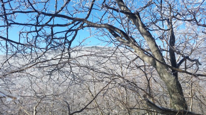
Straight ahead the sun is rising above the slope and shining through the forest’s tangled ice-glazed branches. It’s like the treetops overhead are burning with silver flames.

We emerge from the hemlocks onto a forest road near the eastern edge of the state forest. Water has pooled and frozen solid here, and the gray ice is crisscrossed with white needles, which in some areas have grown into large puffs of hoarfrost composed of large feathery flakes shaped like trees or ferns. The snow, too, is covered with small flat crystals of hoarfrost that twinkle in the sun. (Hoarfrost is produced when water vapor arising from snow or puddles encounters cold air.)


The ascent is steady and uneventful as we follow the ridge upwards towards the summit of North Dome. Hobblebush and waist-high fir saplings make an appearance, suggesting that we’re passing above 3,000 feet and entering the boreal environment. Soon we’re threading our way between taller fir, snow and ice-encrusted, and a short time later here’s the summit marked by a familiar boulder and a canister affixed to a nearby tree (the canister is frozen shut, however, so we can’t sign in).
From here a well-trodden social trail leads west toward the notch that separates North Dome from Sherrill, and it’s nice to have a break from branches and other obstacles. The trail peters out on a waterlogged shelf which is a mix of ice and wet ground, but we keep the sun on our left (which means we’re facing west), and soon the slope is dropping off more steeply and there across the divide looms Sherrill, its icy summit scintillating in the sunlight.
From 60 F and raining to single-digit temperatures in a matter of a few hours — this sudden transition has produced all sorts of odd effects. A dead birch vomits forth a plume of yellow-orange ice, as if the tree contained candle wax that had melted and oozed out during the recent thaw.

We descend into the notch, steering for the high point of the saddle, which is the shortest route between the two peaks. From here there’s a brief but steep climb to Sherrill’ summit and a few icy ledges to squeeze between. We’re wearing spikes over running shoes, but the teeth aren’t sharp enough to grip on steep slanted ice flows, so we look around for other ways up. The ledges are dripping with icicles, thick and thin, sometimes clear and sometimes yellow or orange like the effusion from the birch tree, and some still dripping and growing. They’re like rows of fangs, and presumably all were formed overnight, when the arctic front moved in and cold air caught streams of water rolling off ledges and oozing from cracks.


Everything was wet with rain when the temperatures fell, and now every branch, twig, and bud is encased in a quarter-inch of ice, and in many places the northern-facing edges have accumulated thick coatings of rime ice as freezing fog must have been blowing across the mountain.

We reach Sherrill, sign in at the canister, and drop back into the saddle. So far, the natural navigation has been pretty easy, but now it’s going to get a little trickier, as the return trip involves a contour back around North Dome’s northern shoulder and then a descent into the valley of the mysteriously-named Hagadone Brook.

Contouring sounded like a good idea over breakfast when we planned the route, but now we find the route is difficult because the slope is slanted, which makes for hard walking. It’s so tempting to drop down in search of easier terrain — it’s as if the mountain is trying to lure us downhill — but descending too early would send us down the wrong valley. Meanwhile, we’re crossing over plunging streams flash-frozen into cascades of gray ice, avoiding steep ledges, and punching our way through thickets of ice-glazed hobblebush and beech. It’s always irritating when a branch brushes you in the face, but when it’s encased in ice the extra mass imparts a painful smack.
Behind us Sherrill is glittering in the sun, while to the left the valley is beckoning, but our shadows are in front of us, meaning that we’re heading north, when we need to make our way further east. Looking ahead, I see the sun lighting up another ridge, and maybe it’s time to turn down, but after some consideration, it doesn’t seem like we’ve gone far enough, we need to fight our way over that sunlit ridge first and then look for valley of the Hagadone.
Bushwhacking is a mentally demanding activity. You don’t pass the time talking about friends or sports — total focus is demanded, as you scan ahead for the most efficient route through various obstacles, glance down at your next step, and then look up again before a beech branch slaps your face. When navigating without map, compass, or GPS, you have to pay attention to every locational clue: the direction of shadows, the angle of the terrain, that last glimpse of Sherrill to the rear.
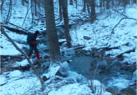
Eventually we get over the ridge, and our shadows shift over to the left, indicating we’re finally moving east. The slope drops off very steeply to our left, and hopefully somewhere down there runs the Hagadone Brook. We keep pushing east for a little longer, reasoning that the higher up we cross that brook, the less of an obstacle it will prove to be. In due course a more moderate slope takes us down into the valley, where we pick our way across the brook on ice-crusted logs and rocks.
We can’t follow Hagadone Brook because it flows out into the valley to the west of where we parked, so once across we contour along the side of a hemlock-clad ridge, while the brooks drops out of sight below us. We’re cheered to encounter yellow blazes again, which tells us we’re back inside that long tongue of DEC State Forest, and then Alan spots our tracks from the morning. But just as quickly we lose the tracks, and then looking up there’s a house in the distance: we’ve wandered too far east. So we zig back to the west, and I’m beginning to wonder whether this bushwhack will ever end, when Alan spies the cars.
It’s been a long day, and during the descent my toes were getting jammed in the front of my shoes and squished by the pressure of the spike straps on top of two pairs of thick wool socks. It’s a huge relief to get in the car and take off the spikes, although the poor toes are soon stinging horribly (they ache all night, but the next day seem OK).
On the drive out along Spruceton Road, I catch sight of the frosted ridge on Halcott Mountain’s northern shoulder, the next high peak west of Sherrill. The icy treeline is burning in the late afternoon sun like a golden fire — and then the sun itself flashes into view through a notch in the mountains, blinding me for a moment.
Once back home, I discover a trip report by pair of adventurous hikers who’d taken a similar route in the fall of 2010. Just like us, they found the long traverse across the shoulder of North Dome and the descent into the Hagadone Brook Valley a little trying. It’s great fun experiencing this route once again, but this time through a different pair of eyes:
This “mere” half-mile traverse to the ridge, however, took us nearly an hour! Oh yes, we tried our best to hike fast, but the mountain wouldn’t allow it. I had been figuring that this traverse would be easy, as we didn’t need to change elevation at all, and I knew that the typical terrain in the Catskills is to have many cliffs and ledges separated by relatively flat terraces. I figured that we could easily travel along the side of the mountain on one of these terraces until we reached the ridge. But no. There were no major ledges. There were also no terraces. Instead the ground sloped off to the north, and it was populated by many mini-ledges, boulders, and small ravines, each of which only served to slow us down and impede our progress to the east. None of the hiking was particularly difficult, but the combination of thick undergrowth and mini-ledges drove us nuts. We made too many quick-checks of the GPS, and every time it told us the same sad story: The ridge was still far, far away and we needed to hike faster. Meanwhile, it seemed that hiking directly sideways on the mountain was impossible. We had to either hike uphill to a nicer-looking area, or hike back downhill to a nicer-looking area. The area we were currently in was always lousy. We zig-zagged along the mountainside like drunken fools, trying desperately to gain easting while maintaining the roughly 3100 foot elevation we needed to reach the ridge top in the correct spot. Reviewing our GPS track afterwards, I was not surprised to discover that this was the slowest we’d hiked all day. It was also the stretch of “trail” with the fewest pictures taken. In other words, we put everything we had into getting to that ridge…..What we really needed to do was to finish this horrid traverse and get down off that mountain!
— JFR, Catskills 2010, http://www.hikingtales.com

