The John Muir Trail is a famous 210-mile hiking route that traverses California’s Sierra Mountains, which Muir referred to as “the range of light.” I visited the Sierras in 2018 and was impressed by the spectacular landscape. After some consideration, thru-hiking the JMT became a goal for 2020.
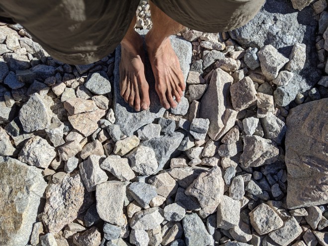
Just getting ready for the JMT was a big operation, as the trip entailed competitive and thus hard-to-get permits, extensive route-planning, careful selection of gear and provisions, and travel logistics that were complicated by the COVID pandemic. Additionally I decided to take on the JMT in an unconventional format by hiking as much as possible barefoot. Why barefoot? For the extra challenge, the special feeling of lightfootedness that comes from moving naturally, and the distinction of doing something important a little bit differently.
The 23-day journey turned out to be an incredible experience; indeed, it contained enough impressions to fill a book. In the interest of brevity, however, this blog post will consist of a short synopsis of each day on the trail and a photograph or two.
Due to the popularity of the JMT and the limited supply of permits to walk it straight-through, my plan ended up with a little twist: I’d start the trail in the middle and hike the north half first. Then, after a few days off, I’d return to the mid-point and complete the south half. Just to reach the JMT and get started, I’d have to hike in 16 miles from the Pine Creek trailhead, a few miles outside the small desert town of Bishop, California.
August 5
Robert from Sierra Shuttle Service dropped me off at the Pine Creek trailhead a little before noon. Now I had to climb 4,000 feet up a steep mountain valley, carrying a 30-lb pack, exposed to the hot desert sun for most of the way.
Hiking without shoes requires a deliberate pace, especially here, as I discovered the footpath was in many places quite rocky. I spent the day taking it one step at a time, trying to breathe deeply in the thin air, and drinking frequently.
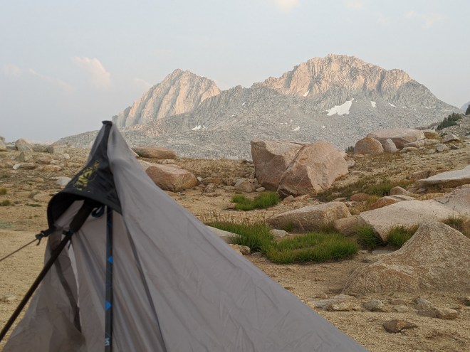
That evening I pitched my small tent at around 11,000 feet, boiled a cup of water to rehydrate a freeze-dried meal, and marveled at the twilight mountain scenery.

August 6
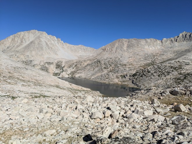
On day two, things rapidly fell apart. I’d spent the night tossing about with a splitting headache. The next morning my stomach reacted unfavorably to the freeze-dried meal – or the altitude – or both. I struggled up to Italy Pass at 12,408 feet, where I found myself looking down the other side into a basin of broken granite ringed by jagged peaks. I might have been standing on the moon.
On the descent from the pass, the footpath became more difficult to follow. There were some modest cairns, sometimes three small rocks stacked together, sometimes only two. Otherwise, the path was visible solely from footprints in the sand, which intermittently disappeared where the trail crossed over open slabs. With a GPS I wasn’t worried about getting lost, but I ended up crossing back and forth over the trail, often without seeing any trace of it, and wandering instead through fields of broken rocks – an extra unwelcome challenge for someone not wearing shoes.
I thought Lake Italy would offer some respite, since the path leveled off around its banks. But the lake lay beneath the shoulder of a crumbling mountain, and cracked and broken rocks had tumbled down to the water’s edge, so the “path” here required clambering over boulders.
Then, a mile or so past the lake, I got stuck on the ridge of a small trench canyon. I scrambled up and down the embankment, searching for the next set of sandy footprints. Frustration at the unexpectedly difficult trail and resulting slow pace had been building all day, and now I shouted out loud in anger and disappointment. It was early afternoon, and I’d made it only 4 miles. The situation raised serious questions about my ability to barefoot the JMT, which I hadn’t even reached yet.
Reluctantly, I pulled on shoes. With some effort, I calmed myself down. After some more exploring, I found the path again (it had taken a sharp jog to the right) and followed it downhill for 4 miles until it finally intersected with the JMT. Even with shoes on, though, my feet were sore from all the rock-clambering I’d been forced to endure.
Nonetheless, since the goal was to barefoot as much of the JMT as possible, I pulled the shoes off again and limped off to the north. Someone noticed my bare feet and asked, “taking a break from the boots?”
“Exactly,” I responded.
After 3 miles on the JMT, I set up camp in a grove of lodgepole pines. It had not been an auspicious start. With 207 miles left to go, I was already half a day behind plan. A ruby-throated hummingbird buzzed by to inspect my hat. Finding nothing of interest, it flew off into the dusk.
August 7
Once again I slept fitfully, plagued by headache, although not as severe as the night before. Once again, my stomach wasn’t happy the next morning. But otherwise, it was a more productive day. I wandered along through dusty pine forests and cool meadows underneath sparkling blue skies.
The JMT was in much better shape than what I’d experienced on Italy Pass. To be sure, in some places the trail zig-zagged downhill and was full of rocks, and these spots were painful, slow, and vexing. But in other places the JMT consisted of silky soft sand, or where it passed streams and meadows, smooth dirt, and here I strode along in high spirits. The contrast between smooth and rough is part of what makes barefooting so intense — and so much fun.
When people asked, “where are your shoes?” I tried to explain the special joy of moving naturally and the extra layer of experience it provided. One hiker sounded intrigued. He said he wanted to give barefoot a try, “but not right now.” A middle-aged woman said her feet were so tender she couldn’t walk barefoot in her bathroom. When a teenager exclaimed, “I could never do that!” I pushed back — “of course you could!”
Silver Pass was a gentle climb along a sandy trail, and from the top I looked at waves of mountains receding to the north. Within this unfamiliar and mysterious landscape, two sharp black peaks caught my eye. I saw banks of clouds massing above them and wondered if the summits had interrupted the westerly winds and disturbed the weather.
That evening I camped next to a sapphire lake, fixed my dinner, lay back, watched the sun descend. Clouds bubbled up around the peaks, and the evening air turned chilly. I’d covered 12 miles, which was a good day’s work. But I was still 5 miles behind plan, which left me feeling uneasy.

August 8
The next morning I woke up late. Alarmed by the lost time, I headed out without breakfast — which was no great loss since my stomach was still feeling queasy. At one point I raced off the trail and in extremis reached for a broad wavy leaf of Corn Lily to use as toilet paper. Probably not a best practice, as this plant is considered toxic.
A whole host of plants caught my eye: larkspurs with flashing blue petals — beardtongues with trumpet-shaped flowers in flaming scarlet — Poison Angelica with pale green flowerheads arrayed in sinister-looking umbrella-shaped sprays. Wandering fleabanes, diminutive daisies with light purple petals and yellow eyes, stared up at me from the trailside with questioning expressions – making me think of the little girl at the hotel in Bishop who’d wandered up to me and asked, “Is that your pen? Is that your paper? Is that your drawing?”
Craving protein for lunch, I pulled out my stash of beef jerky. I’d brought a variety of flavors for the trip, and this package contained the “hot pepper” variety. Soon my mouth was burning, eyes and nose were running, and stomach started rumbling ominously.
Stomach notwithstanding, it ended up a big day. 16.5 miles flew by, as I passed a succession of stunning lakes and gorgeous meadows along soft sandy trails. Now I was only 2 miles behind plan. Stomach still queasy, I skipped dinner and went to bed.
")
")
August 9
Resupply day! It was only a few miles to the Reds Meadow Resort, where I’d pick up supplies and perhaps find some real food.
It was also a day to ponder nature’s power. I walked through extensive blowdown, where violent northerly winds had knocked down 10,000 trees. Then it was into a massive burn with broken trunks sticking from the ground like charred bones. In the distance loomed Mammoth Mountain, an 11,000-foot dormant volcano. Alongside the trail were smaller cones of cinder and slag. I was entering the Devil’s Postpile National Monument, which was established to protect distinctive basalt formations with hexagonal columns, formed from cooling lava some 10,000 years ago.
I reached the Resort and picked up my resupply. Next I called my wife, Sue, and assured her all was well. Then it was time for eggs for breakfast and a little later a delicious cheeseburger and – best of all — an ice-cold lemonade, for the day was turning beastly hot.
Having eaten and drunk my fill, there was no purpose in hanging out here any longer. I shouldered my replenished pack, headed out into the noontime heat, and began climbing the next hill under the burning noonday sun. I felt the ground turning hot underfoot, especially where the sand was a darker color or the path faced south and got the sun head-on. Then I noticed the sand was full of small white pebbles – volcanic pumice – an extra irritant for hot feet. When passing hikers asked, “where are your shoes?” I pointed out that people pay a lot of money for pedicures with pumice stones, and here I was getting one for free.
Eventually I left the volcanic region behind and set up camp in the cool twilight air by a quiet shaded lake. With another 14.5 miles in the bag, I was starting to feel confident about my special goal.

August 10
But new obstacles were waiting. Up and on the trail at first light, I passed two beautiful lakes, Gannet and Thousand Islands, which nestled under the imposing black peaks I’d seen the day before: Banner Mountain and Mount Ritter, also known as the “King and Queen.” These are striking mountains of historical significance – photographed by Ansel Adams, climbed by John Muir. The black color reflects their composition of metamorphosized volcanic rock, rather than typical Sierra granite. This “metavolcanic” rock, I soon discovered, breaks apart into sharp pieces, making it more difficult to walk upon barefoot than granite chunks which have smoother edges.
I persevered, moving at a very slow pace over the metavolcanic rocks. Meanwhile, a murky cloud layer was spreading across the sky. A few drops spattered in the dust, and then the rain intensified. I made a snap decision — that at 10,000 feet in elevation, any sign of bad weather ought to be treated with great respect – and raced off the trail to the bank of a small lake, where I whipped out my tent, swearing in exasperation each time a wet stake slipped from my fumbling fingers – but got it set up and myself inside within seven minutes.
And then the rain blew off to the north and the sun came back out. I took a quick dip in the lake and settled in for the night, but the early stop had cost me several miles.

August 11
Up at 5:00 am. In the interest of time I skipped breakfast and hit the trail at 5:30 am. I was soon up and over Island Pass and then descending into the valley of Rush Creek, which was full of rivulets and lush vegetation including many wildflowers, such as fiery red paintbrush and lupine with stalks of blue-and-white bonnet-shaped flowers. Then it was up to Donohue Pass on a trail that ascended granite steps that had been cut, shaped, and fitted together with artful precision.
For barefoot hikers, the descents are often more difficult than the climbs, because you’ve got to lower yourself down each step carefully – no hopping down and landing hard on sharp gravel or rock fragments. So now I worked my way down from the pass into Lyell Canyon, where I hoped the path would be level and smooth. Thunder rumbled to the north. A few drops spattered around me. I quickly donned rain jacket and pants.
Once down in the valley, it seemed that the storm had moved off. But in its wake the air was painfully cold. There were deep puddles in the dirt. A few steps later, I found the ground covered with clusters of buckshot-sized hail, as if fired from a shotgun at close range. These signs of nature’s fury seemed to validate my conservative attitude toward mountain weather. In terms of timing, I’d been lucky.
I splashed along through the canyon for a few more hours, ending up with 17 miles complete, my biggest day yet. What a nice feeling to have “miles in the bank” and the prospect for an easy day tomorrow. After that I’d exit Yosemite, with my adventurous goal half-way complete.


August 12
Upon waking up I brushed off frost from tent and sleeping bag, and headed out at a leisurely pace, pleased to have two short days left. But there was a nasty surprise waiting for me at the entrance to Tuolumne Meadows: a sign that read 27 miles to go, which was about 10 miles more than I was expecting. I sat down, pulled out map and route plan, and tried to figure out what had gone wrong. It appeared there was an error in the track I’d relied upon. Then I noticed that between me and Yosemite there lay a 6,000-foot descent – a daunting prospect without shoes. Revising my plan on the spot, I decided I’d need to cover 20 miles today. There wasn’t a lot of flexibility, because the only way out of Yosemite Valley was an afternoon bus, which I couldn’t afford to miss.
It ended up being a long day with plenty of challenges, but there were also rewards – passing Cathedral Mountain with its narrow spire culminating in a summit only a few feet wide – spotting an orange Fritillary butterfly resting on a purple daisy – entering another ghostly burned-out forest with massive charred trunks scattered helter-skelter – arriving at a campsite overlooking Yosemite Valley as pink alpenglow spread across polished granite walls two thousand feet tall.
")
")
August 13
Thanks to the big effort the day before, there was now less than 8 miles left, and a hopefully manageable 3,000-foot descent. I passed beneath Half Dome and paused for lunch at Bridal Falls, finding the downhill trail quite reasonable so far. But then it became terrible. The path broke apart into raw granite slag, turned sharply downhill on switchbacks full of rocks, and then — worst of all — for the last couple of miles, it was paved with rough cement studded with sharp rocks. Maybe my feet were tired after 100 miles or so of barefoot hiking, but at this point I found myself moving at a pace as slow as the processional march you’d see at a wedding, or a funeral. Hordes of day hikers streamed past. I pretended to be calm and confident and tried to smile, but was careful to keep sunglasses down to veil my desperation, not wanting to come across as a bad advertisement for barefoot hiking, or some kind of lunatic. The last mile seemed to take forever.
But eventually it was over, and with it I’d managed to complete the northern half of the JMT 100% without shoes. To celebrate this accomplishment I plodded over to the Yosemite Visitor Center and wolfed down two sandwiches and a lemonade. With some luck, in a few days I’d polish off the southern half — although it was a little premature to assume success, for the southern half would involve longer days, higher passes, and other unknown challenges.

August 19
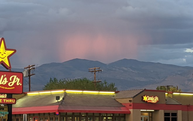
I took a few days off in Bishop to rest and recover and attend to work projects that needed attention. Heavy gray clouds rolled in from the west, and while only a few drops ever reached the desert floor, I watched one evening as the setting sun cast cherry-colored alpenglow against rain showers drenching mountaintops in the east.
Work was touch and go. Duty comes first, and I was prepared, if necessary, to cancel the rest of my vacation, in which case I would return and finish the JMT next year. That would have been disappointing, and the possibility was causing me a lot of stress. But an important conference call went well, and the coast was clear. The next day Robert from Sierra Shuttle Services drove me back to the Pine Creek Trailhead so I could once again hike in to the midpoint of the JMT, only this time to turn south.
I was expecting the second time on this trail to be a little easier, as I was familiar with the terrain and better acclimated to the heat and elevation. And at first the climb went well. But then I got caught in a short but violent rainstorm, which slowed me down and left me chilled. Suddenly the trail seemed much rockier than what I recalled. My energy began to flag. I’d planned to go a couple miles farther this time, but ended up instead camping at the very same spot as before.
August 20
Then things got worse. The difficult-to-follow trail and the tumbles of broken rocks were just as bad as last time, and now a cold wind came howling up the pass, draining me of energy and enthusiasm. By early afternoon, a glance at my watch showed a dismal pace. Once again, I gave up and pulled on shoes and marched down to the JMT, and once again, upon reaching it, I took the shoes off. Then I looked at my route plan and discovered, with dismay, that there were 9 miles to go. I made it three miles and called it a day.
August 21
Determined to make up for lost ground, I started before first light. With some effort, I made it up and over Selden Pass at a good pace. It was the descent into the next valley that dashed my goal to complete the JMT barefoot. It was an endless south-facing slope, covered in manzanita brush, exposed to the midday sun, with long switchbacks full of rocks and gravel – it was too much.
Part of the barefoot practice is the realization that speed and distance goals have a large component of egotism. Once you leave those behind, you learn to drop other goals, too, when they no longer make sense. So now the shoes went on, and the question shifted from whether I could complete the JMT barefoot, to how much of it could I cover that way.
I drifted along through a hot dusty forest with shaggy-barked junipers and immense ponderosa pines. I spotted a mother mule deer trotting along with two fawns. Then I flushed a covey of quail which scattered into the brush chirping quietly. Eventually I arrived at the Muir Trail Ranch, where my next resupply package was waiting. Then I staggered out again, pack now weighed down with 9 days’ worth of food, enough to last me, hopefully, to the southern terminus of the JMT.
That evening I crossed a bridge and entered the Kings Canyon National Park, which I’d never seen before. What’s distinctive about this area is that the Kings River has 5 tributary forks that drain from east to west, which means the north-south JMT crosses 5 big canyons.
 August 22
This morning’s goal was to catch back up to plan, and this meant shoes for speed. Up before 5 am, I powered up a series of switchbacks and arrived in Evolution Basin, where I took off my shoes to ford Evolution Creek. I continued barefoot along pleasant sandy trails for another 4 miles. When hikers asked, “where are your shoes,” I said I’d taken them off to wade the creek, which seemed acceptable to them.
But I was still way behind plan, and time was still of the essence. Back in shoes, I flew past a series of lakes and scrambled up into a high granite basin where blowing clouds whipped me with rain and specks of hail. Reaching the Muir Hut, a small stone shelter built on the highpoint of Muir Pass, I sheltered inside for a few minutes, eating a snack of nuts, dried fruit, and chocolate, while thunder rumbled overhead.
Then I headed down the other side of the pass — and what a change, now that I was wearing shoes, for I was practically running down the mountain. I pulled up for a moment to stare in amazement at jagged peaks with streaks of black and brown and red, and then resumed the descent, hopping lightly over the chunky debris that littered the trail. Maybe barefoot training had helped me become more nimble and sure of foot. Maybe I hadn’t totally lost my ultra-running legs. In any case I danced down the steep trail, rushed into Starr Camp at dusk still full of energy, whipped out my tent, and set up camp on a rocky knob.

August 23
Yesterday’s effort bagged me 22 miles. This morning I rose a little later and sauntered along barefoot for a few miles, before putting on the shoes. A few miles later I reached a junction in the trail and began to ascend, eventually reaching the base of the “Golden Staircase,” which consists of a series of switchbacks and stone steps leading to the base of Mather Pass. Completed in 1938, the Golden Staircase was the last link in the construction of the 210-mile JMT.
Suddenly I had an idea: why not take on the Golden Staircase barefoot? It would be a special challenge, with a dash of machismo, that would give me some bragging rights.
Surprisingly, the Golden Staircase turned out to be a wonderful experience. There was always somewhere to step: the rock cobbles had small flat surfaces, there were occasional patches of sand or large smooth rocks lining parts of the trail, and even in the worst jumbles there was always a place to fit a heel. Yes, the trail required constant focus, and yes the pace was slow, but the time passed easily as I moved carefully and deliberately. It was a reminder that most of the pain and aggravation I’d suffered earlier was in my mind – a function of unrealistic goals that couldn’t be met – whereas if I let my feet set the pace, all seemed to go well.
That evening, while sitting in my tent and writing up a few notes, I gave the Golden Staircase a Gold Star.
August 24
The next morning I continued barefoot on the rocky trail until I reached the summit of Mather Pass. The views were stunning. To the North, a U-shaped valley plunged into the distance, lined with ragged peaks on either side, their shoulders cloaked in fields of scree, while in the depths below there glimmered an emerald lake. To the South, broad flat plains rolled off toward the horizon, and beyond the plains there were waves and waves of mountains – I counted 13 separate ridgelines colored brown and gray and, farther off, turning blue.
The plan was no longer at risk, at least for now, but surveying the rocky descent from Mather Pass, I opted once again for shoes. Nearing Marjorie Lake, I looked up from the dry yellow sedge and red heather that grew along the trail, spotted huge cumulus rising into smoky haze, heard peals of thunder overhead. If I kept trucking, I might escape the danger zone. When I reached the lake, the air was calm, although clouds continued forming overhead.
That night I woke up to the sound of rocks clattering down a slope. I lifted the tent flap and peered out at the stars and galaxies of the Milky Way.
August 25
The next morning, on the way to Pinchot Pass, a man and his son passed me, and then at the top, I found them again, joined by two companions. They offered to take my picture, and I happily returned the favor. The man’s trail name was “Chupacabra,” his son was called “Sherpa,” their companions were “Rico” and “Jesus” (the latter on account of a wispy beard), and they hailed from Long Beach, California. I took an immediate liking to this group — they seemed friendly, open, experienced, confident. With shoes on, they quickly left me behind, and I was sad to see them go.
This morning’s task was to stay barefoot on the descent, applying the lessons from the Golden Staircase. I stepped carefully down the rocky trail and let my feet set the pace. The result was another positive experience — six hours of calm, joyful, natural movement, even where the path was steep and full of rocks.
A couple of passing hikers were impressed by my barefoot practice. “Impressive,” one said, “unbelievable,” commented another — to which I replied, “but slow.”
Eventually I put the shoes on again to make up some time. Up ahead, I spotted a mama bear with two cubs moving along the trail (how their warm brown fur glowed in the sun!). I sang a song to alert her to my presence; she glanced back and hustled along a little faster. Next I encountered a grove of foxtail pine — tall, stout, ancient trees with orange bark and a scent reminiscent (to me at least) of reposado tequila, smooth, complex, aged.
Arriving at Arrowhead Lake, I found the Long Beach gang had saved me a spot. I hung out with Chupacabra for a little bit, learned that he had been “hiking hard” in the Sierras since the 1980s (he took Sherpa out for his first hike at age 3!). That was 40 years of hiking in the Sierras, which seemed to me an extraordinary wealth of experience.

August 26
I was nearing the southern terminus of the JMT, the summit of Mt. Whitney, and the end of my personal journey along the trail. Excited to be closing in on my goal, I was up at 5:00 am and on the trail by 6:00. But this morning it seemed exceptionally cold and windy. With exposed feet and a slow pace, I couldn’t get warmed up. I crept along, miserable, a shivering animal. Once at Glen Pass, I put on shoes, moved a little faster, was eventually rescued by the rising sun.
Reaching a stream a little later, I saw a sign indicating that Forrestor Pass, the final hurdle in Kings Canyon, lay 7 miles away. Why not climb it and bag two passes in a single day? This seemed like an audacious goal, and it would also shorten my journey by a day, which seemed like a good idea since I was beginning to run low on food. So I hurried off.
A little later I came across the Long Beach gang and invited them to join me. But they had already reached their designated campsite. I got the sense that Chupacabra put a lot of thought into his route plans and stuck to them. We waved goodbye.
Forrestor was a long time coming. The path climbed past a green glacial tarn, where I sat on the bank, ate a freeze-dried dinner, and watched a group of small frogs. Then it wound higher up into the mountains, curled around to the right, and finally inched up toward a notch between two peaks. Down below were expansive rolling plains, which would lead in a day or two to the final ascent of Mt. Whitney.
Dusk was falling as I descended from the pass. Twilight faded, and it became pitch dark, but for the light of the half-moon. But the moonlight was sufficient for me to see the shining white granite rocks that dotted the path, the occasional clumps of mule dung, and divot holes in the sand from hikers’ trekking poles. Headlamp off, I sauntered along until 9:00 pm, at which point I found a flat spot behind a boulder and unrolled my bag.

August 27
Most nights I felt a little chilly inside my sleeping bag in the hours before dawn, but this time I was freezing all night long. It was almost 7:00 am before I finally crept out, just as the sun’s rays were reaching me.
I hoped the rolling plains I was crossing would have sandy trails, since the terrain was not as steep as what I’d seen in Kings Canyons. At first, however, the path was full of rocks, and so was the ground on either side. But as the JMT headed across the Bighorn Plateau, I was rewarded for my patience with silky soft sand — and what a joy to stride along barefoot on this lovely surface!
Bighorn Plateau is home to wild sheep. I had seen these magical snow-white, sinewy creatures on a mountain once in Utah. Today when I paused for lunch, a speck of white fur drifted by.
A little while later I crossed paths with a woman hiker who asked what seemed to be everyone’s favorite question: had I lost my shoes?
“No, ma’am,” I replied.
Was I giving my feet a break?
“No, ma’am, I’m walking on them.”
“Is that how you’re hiking the trail?”
“Yes, ma’am, about 50/50 barefoot and in shoes.”
I told her I’d just descended from Forrestor. She said she’d last crossed the pass in early July, while there was still snow. That earned my respect.
I continued along and after a little while encountered an elderly man descending the trail.
“How does that work for you?” he asked.
“It’s great fun to move naturally,” I replied, “although it’s very slow where the trail is rocky.”
“It must be good for your balance,” he suggested.
“Yes, exactly, barefoot forces you to step carefully and keep your balance at all times.”
“I use trekking poles for balance.”
“I do, too, but sometimes feel they become crutches, that I’d be better off without them.”
“I find the poles most important when I’m tired,” he replied, “because then my balance is wiped out.”
An hour later I reached Guitar Lake, my destination, and set up camp for the night. Although it would be a short night — to reach Whitney’s summit in time for sunrise, I planned to get up at midnight.

August 28
The alarm on my phone went off at midnight. My watch read “0:00,” and at first I thought it had malfunctioned, until I realized those were the correct digits.
At 14,505 feet, Mt. Whitney is the tallest mountain in the continental U.S. Needless to say, I was determined to climb it barefoot. The summit lay 4.6 miles away and 3,000 feet above.
The setting moon cast an orange glow across Guitar Lake as I heated a cup of tea, packed up, and headed out. I decided to monitor my progress by watching the mileage and elevation on my watch, but when I pressed the button to activate the readout, there was no response. The watch had indeed malfunctioned. I would have to pace myself.
From studying the map, I knew that a series of switchbacks would take me up onto the crest of the summit ridge. When I reached the first switchback, I muttered to myself, “Switchback 1, out,” as a way to keep track of progress. When I reached the turn, it was “Switchback 1, back.”
After zigging back and forth, I was just about to mutter, “Switchback 7, back” when I saw lights up above. A trio of young women from New Hampshire had paused at the final trail junction to adjust their packs. I was cheered to see other people.
Now there remained 1.9 miles to the summit, along a twisting trail with steep drop-offs out there somewhere in the darkness. Passing a notch in the ridge, I glimpsed the yellow lights of Lone Pine, California, 10,000 feet below.
I walked on in darkness, conscious only of the next few feet of trail illuminated by my headlamp, the feel of rock and sand underfoot, the placement of my trekking poles, and the sound of my breathing. In certain places large rocks blocked the trail and had to be climbed over. Even so, following the trail was not difficult, but in the dark, at 14,000 feet in elevation, everything had to be done carefully. A scene from the movie 2001: A Space Odyssey crossed my mind. The astronaut Dave Bowman must deactivate the ship’s HAL 2000 computer system, which has malfunctioned. His task is not difficult, but it must be completed in a certain sequence. HAL pleads: “Dave, stop. Stop, will you? Stop, Dave. Will you stop, Dave? Stop, Dave. I’m afraid. I’m afraid, Dave. Dave, my mind is going. I can feel it.” The only other sound in the scene is Dave’s breathing.
The trail turned upward, into a cold wind. I paused for a moment, unsure which way to step. The New Hampshire women passed me. I followed them to the surveyor’s hut on the summit, where we huddled inside. It was in the low 30s when they started, one of the women commented, and probably colder now.
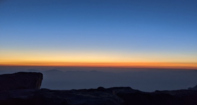
At 5:20 AM, we stepped outside. The eastern horizon had turned dusky orange and red. Smoke from recent forest fires filled the valleys and spread off into the distance. Sirius the Dog Star shone overhead.
Slowly the orange and red expanded, until smoke and haze and clouds were transformed into a vast glowing expanse, reminiscent of the rolling plains I’d crossed the day before. Sirius faded away. It seemed to me that the sky had become itself a range of light.
I retreated to the hut to heat some tea. Sitting there, I estimated that I had completed 70% of the JMT barefoot and 30% in shoes. The next lottery for permits would open in February. That gave me almost six months to think about what, if anything, I should try to do next year.
After a last look around the summit, I turned to face the 6,000-foot descent to the Whitney Portal. Shoes back on again, I walked off down the trail, thinking about work and family, and wondering about what kinds of surprises life might have in store for me when I finally made it home.
Running the Long Path is my account of a 350-mile run in pursuit of a fastest known time record and what I discovered along the way. (Click on the image for more info)

“Part of the barefoot practice is the realization that speed and distance goals have a large component of egotism. Once you leave those behind, you learn to drop other goals, too, when they no longer make sense.”
So true!
LikeLiked by 1 person
I really enjoyed reading this account . . . sort of “hiking vicariously” along with you. Your photos helped me imagine this vast, beautiful, and sometimes stark landscape–but home to flowers, pollinators and other creatures as well. I’ve logged a few barefoot Eastern Sierra miles (mostly repeat visits to Little Lakes Valley, a place of fond childhood memories), and so I especially enjoyed how you “broke down” the different sections of trail in terms of their barefoot-ease. And you made it to Whitney’s summit (something of a barefoot bucket list item for me)! Well done!
LikeLike
Really well done, and such writing. Blessings for the fall season. Worth re-posting. These articles are gems, in all sorts of ways, and a lot more people should become familiar with your work. – Ira Rohde
LikeLike
[…] biggest undertaking last year was spending three weeks on the John Muir Trail, a 211-mile footpath through the mountains of California’s Sierra Nevada. Certain sections […]
LikeLike
Need a shot of bare feet with microspikes in the snow! Unfortunately there is little snow this year…
LikeLiked by 1 person
[…] Last year I set out to complete the John Muir Trail (JMT) with a twist. I’d hike it barefoot. Why? Barefoot is simple. Natural. Intense. Every step is an adventure. But the terrain was more difficult than I expected. Out of the JMT’s total distance of 211 miles, I completed 150 miles barefoot, or about 70%. […]
LikeLike
[…] barefoot — an intense experience in California’s High Sierra and an improvement from the year before (but still short of my goal of doing the entire 211-mile trail without […]
LikeLike
[…] even though it took three tries in the last three years, Ken finally achieved his goal of shoelessly backpacking California’s […]
LikeLike
[…] indoors. I came up with a plan to escape the malaise, at least for a month, with a thru-hike of the John Muir Trail. Once again, New Hampshire seemed like an ideal training ground, in this case for a shake-out […]
LikeLike