The Nine is not for the faint of heart. It’s a daunting 20-mile route which summits nine of the Catskill High Peaks — and it’s longer if you get lost, for what’s especially challenging is that five of the peaks have no trails, which means it’s necessary to “bushwhack” or move through the forest using map, compass, and GPS. Even with this gear, navigation is no simple task, for the terrain is steep and rocky, and the forests thick and tangled, which renders “the eye of little service,” as Catskills author John Burroughs wryly noted.
I had completed the Nine, or parts thereof, on several occasions: once trying to run it for speed, once at night, once in the winter. In April 2016, as a novice barefoot hiker, I tried to complete the Nine without shoes, but after six of the peaks I’d had enough. A year later I tried again and this time gave up after a single peak, defeated by the rocky trails.
Over time, my practice of running and hiking continued to evolve in a minimalist direction. I developed an interest in “natural navigation” (moving through the forest without technology — meaning no map, no compass, no GPS). I began to incorporate intermittent fasting into my dietary and training plans. And I became somewhat more experienced at going barefoot. One day these themes coalesced in my mind, and I came up with a grand plan: to complete the Nine not only barefoot, but navigating naturally, and without carrying food or water. I would call this the Diogenes Challenge, after the ancient Greek philosopher who advocated for simplicity and self-discipline.
Upon reflection, however, the Diogenes Challenge seemed like a little too much, even for an arch-minimalist like me. I quietly let it slide and focused on other things.
Until one day my friend Kal Ghosh asked, when were we going to do it?
You may have seen an image of Diogenes, holding a lantern aloft in daylight, searching for an honest man (he never found one).
Diogenes lived outdoors with only three possessions, a cloak, satchel, and staff, and Kal I debated how to interpret his kit for a modern-day challenge. At first we thought we’d leave behind sleeping bags and lights, since Diogenes didn’t have them. But after discussing weather conditions in New York and ancient Greece, as well as the need for us to start a little late, we relaxed those standards. We would complete the Nine barefoot, navigating naturally, without carrying food, and drinking only from springs.
Our operation kicked off at the Denning parking area at 7:00 pm on Friday, June 12. We ambled off into the cool evening air, moving at an easy pace, with Kal in the lead. The two of us have a lot in common: corporate workers, barefoot runners, past participants in the Escarpment Trail Run. We’re also different in many ways, and as we sauntered along, there was plenty to talk about: history, current events, personal stories, athletic goals, not to mention the different surfaces we were treading on.
The trail toward Slide Mountain is full of large, tilting, “ankle-busting” rocks that make walking difficult no matter what you’re wearing. Kal and I kept up a slow but steady pace, availing ourselves of dirt and grass along the trail’s edge, or aiming for flat rocks to step on instead of pointed ones.
Turning onto the Curtis-Orimsbee trail, we found a more pleasant surface, for this path was composed of dirt, leaves, and fir needles. The path curled up along a ridge and snaked through gaps in sandstone ledges — steep enough in places to leave me short of breath.
Meanwhile, the light was dimming. We reached a vantage point near 3500 feet, but there was little to see as it was nearly dark now, with just a faint glow along the horizon. We persevered without lights. I could see the white of my feet and light-gray sandstone rocks, but the path itself had become so dark it looked like water. I was surprised each time I placed a foot upon the ground and it stayed dry.

Walking barefoot in the dark is a magical exercise: it teaches you to step slowly and carefully, requires good posture and balance, and seems to activate circuits in the mind we rarely use, judging from how even the faintest bit of light was enough for us to place our feet (subconscious foot-eye coordination?). But walking barefoot in the dark is slow. Eventually we could no longer see the trail. At this point we clicked on our lights.
Nearing Slide’s summit, the surface changed again. Now the ground was littered with the rough conglomerate of the “Slide Mountain Formation” and the path was covered in fine gray sand, which was pleasing to the soles, and gray pebbles and knobby rocks, which were not. I asked Kal what he thought — “Well, it’s interesting,” he replied. The constant change in surface conditions is part of what makes barefooting an adventure.
We paused on Slide’s summit, pleased to have completed the first peak of the Nine. It was pitch black now. In the distance, a few lights from the city of Kingston or its environs. Overhead, the sky was clear and full of stars. It was getting cold. My breath was steaming in my headlamp.
After stopping for some water at the spring, then descending Slide’s steep backside, we pulled up around midnight at a primitive campsite, where we spent a cold night. My sleeping bag is rated to 32 F, but that’s a survival rating, not a comfort rating, and I spent much of the night shivering, while Kal, who’d brought a synthetic blanket, was so cold he got barely any sleep at all.
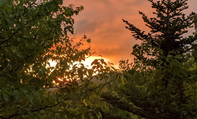
Nonetheless, with eight mountains still to climb, the next morning we were up at first light, packed, and on the trail a little after 5 AM, with Kal once again in the lead, while I lagged behind, feeling cold and sleepy, my stomach growling without its customary breakfast and cappuccino. The sun flared gold and red against the clouds, and then a few minutes later we were treated to a misty morning scene from Wittenberg.
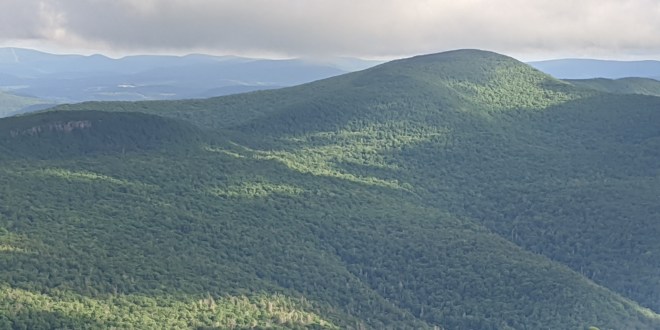
With these two peaks bagged, now it was time to enter the forest and put our natural navigation skills to the test.
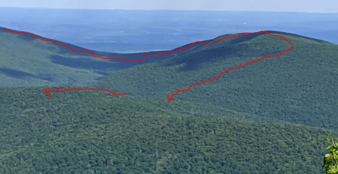
We’d backtracked to Cornell, where Kal and I probed the woodline for the best point of entry. Then we stepped off the trail and into a welter of spindly fir trees. To reach Friday, the plan was to orient ourselves to the south by keeping the early morning sun on the left; then we’d aim to hug the mountain’s eastern edge, which is steep and distinctive.
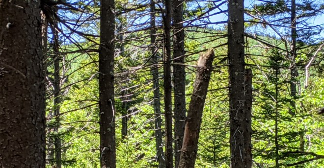
“At least we’re off the trails,” Kal commented. For barefoot hikers in the Catskills, the trails are much rockier than the forest floor, which is covered in a springy mix of club moss, fallen leaves, and fir needles — although in the fir forest there are lots of scratchy sticks and fallen branches with sharp points. I got a small scratch on on the sole of one foot and stopped to put on some tape to protect it. Even with these kinds of hazards, I prefer barefoot to shod hiking, because I find that I can fit my foot into just the right spots on the uneven forest floor, and the sense of touch helps me keep my balance.
As we made our way through the thick forest, a faint path began to appear where other bushwhackers had passed this way. It was sometimes visible from a faint compression on the ground and sometimes a scuff mark on a fallen log, but mostly from the absence of protruding branches which would otherwise have scratched and poked. These kinds of “social” or “herd” paths (Kal called it a “goat path” while I liked to think of it as a “ghost trail”) are the best way to move through dense forest, because they follow logical routes, weaving around the worst obstacles, and because they concentrate human impact in one place, leaving the rest of the forest unscathed. There’s an art to following these trails — it’s called paying attention. And we did, in due course, reaching the canister on Friday’s eastern edge.
Now we could relax, as the trail to Balsam Cap was familiar. In fact I’d been here just two weeks ago in the company of legendary Catskill hiker Ralph Ryndak. Descending from the summit, we stopped for a moment on “Ralph’s Ramp,” where I filtered some water from a seep running down the cliff. A few minutes later we found ourselves standing beneath the canister on Balsam Cap, the excellent social trail having wafted us to the top in seemingly no time at all.
Now we faced a critical point in our journey, for there is no social trail from Balsam Cap to Rocky. We now would need to turn from south to west, otherwise we’d plunge into the depths of Peekamoose Valley. However, if we turned too far, we risked getting sucked into the Neversink Valley. Judging that the sun should be in the southeast, now that it was a little later in the morning, I turned until the shadow of my head was to the right and slightly behind me, and then we headed off.
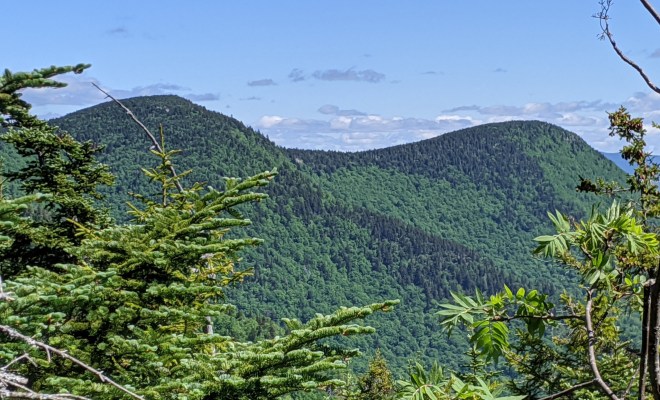
We dropped down a steep slope, under thick canopy, totally blind to the surroundings. The slope leveled out for a little while, which didn’t seem quite right. Then it began to drop again. Finally, through a gap in the canopy just a few leaves wide, a glimpse of a fir-clad ridge — that had to be Rocky! And then it was gone. We kept pushing forward through hobble-bush and birch and beech until we reached the base of a band of cliffs.
Going uphill is a simpler exercise while navigating in the mountains, because if you keep climbing, sooner or later you must reach a top. After scrambling up a few more ledges and back into fir-spruce forest, we spotted the bright orange canister on Rocky’s summit.

Six down, three to go. From Rocky to Lone would be the last real bushwhack, I commented to Kal, because there’s a very good social trail from Lone to Table, after which we’d be on the trails again. So let’s stay focused, I said, and not screw up!
We pushed off down Rocky’s backside, still orienting west, the sun still hanging in the sky on the left, our shadows still on the right, although I cautioned Kal that the sun moves rapidly overhead at noon.
We fought our way through dense stands of fir and spruce. The forest seemed unfamiliar (I hadn’t been through here in at least two years), and I began to feel uncomfortable. Kal was lagging behind, the effects of his sleepless night catching up, but he thought we were a little below the ridge crest, so I edged uphill — when suddenly through a break in the forest, there was Lone Mountain, looming above us and to the front.
It was a steep climb up Lone, but once on top, our navigational challenges were over, or so I thought. We marched off along the social trail to Table, which is well-used and easy to follow — but then we lost it. I’d spotted an easy way down through a gap in the rocks, figured the trail went that way, but it must not have, as no further signs were evident. However, the northern corner of Table mountain was visible in the distance. So we decided to plunge straight down the mountain in that direction. Bad call!
Now the forest thickened, and Table disappeared. I climbed a few feet up into a twisted birch tree, but couldn’t see a thing — although open views to the right meant that Table had to be somewhere to the left. We tried to contour across the slanted terrain. From behind me, Kal kept insisting we push further left. I was growing exasperated, for what was supposed to be easy had turned into a problem.
Then Kal spotted light through the trees above us and suggested we head uphill.
“What, climb back up Lone Mountain,” I protested, “are you out of your mind?”
I was about ready to call it quits and pull the GPS out of my pack.
“But look at the sun,” he said. It was in front of us. I stood there perplexed (wasn’t it supposed to be on our left?) — until finally I realized that it was late enough in the day for it to have swung over into the west.
Then I became even more confused, because if we were heading west, then it stood to reason we were already climbing Table — when I was convinced we were circling back up Lone! But when I looked behind me, there was a big mountain visible through the trees, and it didn’t look like Table. To my surprise, a few steps later we stumbled onto the social trail, and it took us straight up to the top of Table.

Well, finally the natural navigation was done. From here, five miles along the official blazed trail would take us to Peekamoose and back to Table, and then down into the Neversink Valley and to our cars.
You’d think this would be the easy part, but the trail down Table was steep and full of rocks, and by this point, soles, ankles, knees were getting tired. To keep from poking feet and jarring joints, each step required concentration and balance. We marched down the hill in silence. It took a long time to reach the cars.
At 7:00 PM, 24 hours after we’d first started, we arrived back at the Denning parking area, congratulated ourselves for the successful completion of the Diogenes Challenge, and said goodbye. I don’t know how Kal spent Sunday, but I relaxed, put my feet up, and enjoyed a beautiful day at home.
What’s the point of the Diogenes Challenge?
We all rely on gear and technology to such a large extent in modern life, and generally it does the job — but the risk is that we become dependent on this stuff and lose some of our natural strengths and capabilities. Just like children given calculators may never learn to add or multiply in their heads.
- Going barefoot teaches balance, agility, a light step, and patience
- Going without food teaches the body to burn fat efficiently, helping to break dependence on sugary snacks
- Navigating naturally teaches you to understand the lay of the land and pay attention
You can come up with your own challenge, which doesn’t have to be exactly the same as what Kal and I did. If you do so, at a minimum, the experience should help you clarify both the benefits and costs of various types of gear.
Maybe you’ll discover that you can get by with less. And maybe, just possibly, you’ll find that moving naturally, the way our distant ancestors did, is actually a lot of fun…
Good luck!
Running the Long Path is my account of a 350-mile run in pursuit of a fastest known time record and what I discovered along the way. (Click on the image for more info)

Wow, Ken, that was really impressive. i can’t believe you did all that with no food. It makes me hungfry just thinking about it. And I say naught about no shoes.Happy Father’s Day!Love,Mom
LikeLiked by 2 people
Pretty amazing; glad you had someone to share the adventure with. And another amazing write-up. Happy Father’s Day.
LikeLiked by 1 person
Thank you Ira
LikeLike
[…] Print […]
LikeLike
[…] 24 hours including a chilly overnighter, but we completed the mission and called our adventure the Diogenes Challenge after the ancient Greek philosopher who advocated for a life of simplicity and […]
LikeLike
[…] And then I forgot about the idea. Unfortunately, I’d mentioned it to my friend Kal Ghosh, and one day he reminded me. On June 12-13, 2020, Kal and I completed the Nine barefoot, without carrying food or water, and without using maps, compass, or GPS. We called this minimalist adventure The Diogenes Challenge. […]
LikeLike