The week before Labor Day is typically pretty quiet in New York, and with nothing much on the calendar, I couldn’t bear sitting around idle, so I threw together a quick jaunt up to the Adirondacks with the goal of making progress on the 46 high peaks (as a result of the trip, I’m now at 24/46). Here are some quick notes…
Macomb
Starting from the trailhead below Elk Lake Lodge, a two-mile walk on a level trail between Elk Lake and Sunrise Mountain, and at first it’s a soft dirt path — but that doesn’t last, soon enough the gravel shows up. Annoying but no big deal. When barefoot, you take it as it comes.
Near a lean-to, a small cairn marks the turn-off onto one of the Adirondacks’ so-called “unmaintained” trails (in my experience, these are no worse than the “maintained” trails). Voices rising from the lean-to: people talking as they pack up. I head up a steep trail which follows Slide Brook up the mountain, from time to time hearing those voices behind me.
At the top of Slide Brook, the trail turns into a little bit of an adventure: it heads up a steep wash, a tumble of rocks and sand, with various paths through the debris marked by footprints, wherever prior visitors made their way up, and sometimes a little cairn. There’s no exposure, but it’s steep enough to be awkward, requiring hands as well as feet, in some places I’m stepping through a mix of sand and gravel, in other places clinging to small trees or roots as I pull myself up an exposed rock face. The voices keep following me: a hundred yards or so below me two women slowly moving upwards.
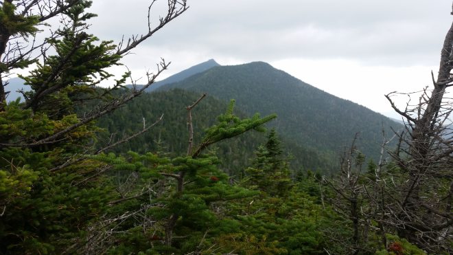
The summit’s marked by an exposed boulder and socked in with blowing fog.
South Dix
South Dix is an shorter mountain than Macomb, little more than a bump on the ridgeline.
The wind is tearing back and forth through the fir and spruce trees. It sounds like a free-for-all, with different winds gusts wrestling with each other to see who’s toughest and can blow the hardest. I pull on my goretex jacket for some protection. The sleeves snap and flutter in the flow, and I struggle to stay upright.
Grace
A 1.1-mile out and back to the east-north-east connects South Dix to Grace. A nice trail, not too steep, with plenty of dirt and some mud.

I encounter a couple on the way back. We talk about the wind, which the fellow estimates gusting at 50-70 MPH.
On my way back from Grace, here are the two women who followed me up Macomb. We talk about the purple mushrooms growing along the trail, which are likely Cortinarius violaceous, or violet webcap.

Hough
Now heading north on a big ridge that leads eventually up to Beckhorn and Dix, and as I dip into the intervening saddle and then begin the 700-foot climb to Hough, the winds continue to tussle with the trees, sometimes whipping them back and forth, but on the trail I’m sheltered from the blast. Beckhorn comes into view, a subsidiary peak of Dix, but from this angle quite distinctive, a sharp rocky protuberance on top of the mountain.

Dix
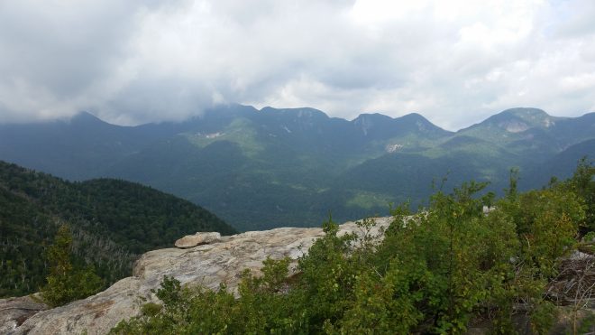
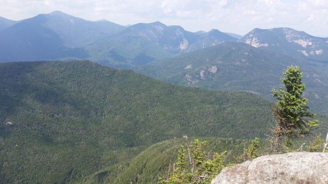
Passing Beckhorn, whose summit is occupied by a group of high school kids, it’s on a short distance to the summit of Dix, which is slightly higher but less dramatic. The sky has cleared and the winds calmed to some degree, although clouds continue to drift across the sky, giving the vistas a steamy look. Elk Lake is especially prominent in the valley, as is the next range to the north and what must be Nippletop Mountain (tomorrow’s business).
I’m eager to get back. “Where’s the down button?” I ask, and the kids point me to where the trail drops down the west side of the mountain.

The trail scrambles down some exposed anorthosite (the rock type of which the Adirondacks are generally composed), helpfully marked with painted yellow stripes (this is a “maintained” trail). Then it tunnels into the spruce-fir forest at a reasonably level grade for a short distance, before plunging straight down the mountain and turning into a typical Adirondacks disaster: heavily washed out, a tumble of muddy slick rocks and tangles of roots. Upon reflection, the Adirondacks have some of the worst trails I’ve seen anywhere. These conditions require a painstakingly slow pace, regardless of whether you’re wearing shoes or going barefoot, unless you are young, and indeed a couple of the kids pass me by. I catch up to the couple I’d met earlier, who are complaining about their knees. Passing shod climbers on a difficult downhill is a small triumph, and needless to say I immediately slip on a muddy rock, slide three feet, and scratch a foot. A few steps later, here’s one of the high school kids who’s fallen and cut his hand. I give him a bandaid and some tape. If not young and fast, at least I’m prepared. By the way, a high injury count is one measure of a poorly designed trail.
Down at the bottom, the trail levels out, and now the couple catches me. They stop at Lilian Brook, where they spent the prior night, to gather their overnight gear, and now I pass them once again. This has become a race, and I’m back in the lead.
Four miles of relatively level trail back to the parking area. I run a few steps here and there where the trail is flat and level enough to do so, although much of the time making forward progress feels like putting together a jigsaw puzzle: each step requires finding a spot for my foot in spaces between big and small rocks or on top of them, or in between roots and mud puddles. It’s chaos, like walking through a junk yard, lacking only broken glass and barbed wire. From time to time voices behind me — the couple, the two women from Macomb, or strangers? I redouble my efforts, trotting along wherever possible, feeling (when I get it right) how the correct posture and technique allow the feet to bounce off the rocks….only to be worn down and finally defeated by that long gravelly section, which I knew would be waiting for me, and which has become worse on the return trip now that my feet are a little tired. The voices are gaining, but just before they catch me, I turn onto the final stretch, regain a smooth dirt surface, a chance to jog a little, and I arrive a few seconds before the Macomb women, and we sign out on the register together. As I’m backing out of the lot (trying not to hit the school bus waiting for the last of the high school kids), the couple arrives.
Fun to see others out on the trails and especially kids scampering up and down these mountains — one sometimes wonders in this age of technology whether young people are losing interest in the outdoors.
Dial
The next day, I pull into a parking lot in St. Huberts, and what a surprise, the first mile is a walk along a dirt road — not a gravel road, but smooth soft beautiful dirt. For a barefoot hiker, this is a real treat, in fact, I can’t recall ever encountering such a soft road.
The road passes into the lands of the Adirondack Mountain Reserve, a private club. Signs advise hikers to keep to the marked roads and trails and to yield right of way to the AMR bus. In due course, a green school bus labors up the road and I dutifully step to the side. I wonder if in some scenario I could catch a a ride on the way back, but dismiss that thought as it’s for AMR members only.
A trail heads off into the woods and then steeply uphill, but it’s covered in dirt and hemlock needles — much nicer than typical washed-out Adirondacks tumble of rocks. It continues through a grove of young birch and up to an knoll on the ridge called Bear Den, which offers views of Dial Mountain and the surrounding valleys. This morning is warm and humid, but with a strong breeze. Sun and shadows alternate as clouds stream by.
400 feet or so to Dial, a moderate climb and enjoyable, and on the summit a hiker coming the other direction. My plan has me continuing to Nippletop and then, depending on time and conditions, bagging Colvin and Blake, too, although that would make it a very long day. The hiker warns me that the gap between these two peaks is very steep and slow, in fact the 2-mile round-trip between the two took him 3 hours (and that’s in shoes). My heart sinks, and a for a moment a battle rages in my mind: to press on or not? Then I realize that, instead of going back and forth, there’s a solution to this question, which is not to make the decision now — since I won’t reach that junction in the trail for several miles — but rather to adopt what in the business world is called a “leaning” — as in, “I’m leaning 60/40 against trying to climb Colvin and Blake, based on this hiker’s commentary, the chance of rain later in the day, and a little bit of a late start.”
Nippletop
The trail continues up the ridge at a moderate grade with a smooth dirt surface — by Adirondack standards, this is a beautiful trail, and I’m moving steadily and enjoying the day.
It’s a little windy at the top, but clearer than the day before. I unfold my map and try to line up the shapes in the distance with the contour lines on the paper. There are Colvin and Blake lying just to the north, with a sharp cleft between them (I can see how that would be slow). Behind them the High Peaks range with what I take to be Sawteeth Mountain looking especially grisly. Further off it looks like the top of Marcy. To the south, a straight-on view of Dix and Beckhorn, with their steep flanks covered in washes and slides. Behind them diminutive South Dix (easy to overlook) and Macomb with three bumps on top. To the east, Giant Mountain looking very prominent.

The trail going down is difficult. Straight down the side of the mountain, steep, washed out, nasty. I’d like to ask the people who built this trail, what did they think would happen over time as water poured down the path? Was it their aim to create a trail or did they think the mountain needed another intermittent stream bed? Interestingly, every so often a drainage ditch has been dug to divert water off the surface of the path, and in some places these have done their job and the path is flat and dirt-covered for the next few yards, but then it turns a corner and plunges over exposed boulders or tangles of roots. This is slow exacting relentless work barefoot, because I’ve got to step carefully, can’t jump, can’t afford to slip and tumble. My knees are starting to feel it, too. Now I’m leaning against trying to do Colvin and Blake, too, by about 99 to 1.
An extraordinary profusion of fungus lining the trail in red and yellow, some smooth, some textured with bumps or speckled.


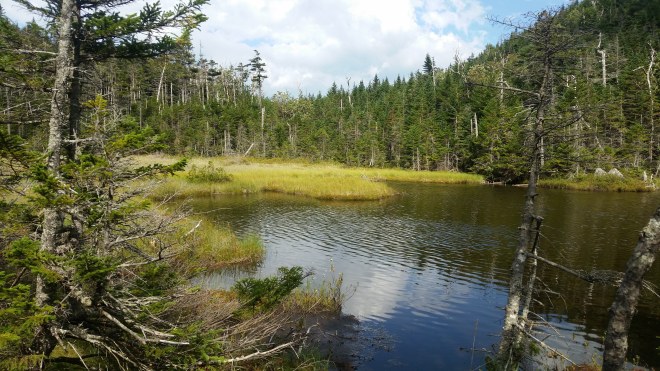
The trail passes over a stream and between two ponds on newly-installed wooden planks. The turn-off to Blake and Colvin passes in the rear-view mirror.
It gets very dark. A little later, a brief shower. The rain gets heavy and is very cold. Out comes the goretex jacket.
Eventually it’s back to the dirt road, which has a scattering of gravel on it here. I’m walking on the grassy shoulder when the green AMR bus pulls abreast of me. The driver lowers his window: “want a ride?” The driver makes an exception to the member-only rule given the rain. Later on he picks up another pair of hikers and drops us all off at the main gate. We thank him profusely.
It’s stopped raining. The last mile to the car is back on that pleasant dirt road, which is now so wet it feels like walking on a sponge. Across the way looms Giant Mountain. A large white cloud is passing over its summit dragging tendrils of mist up and over the mountain’s steep flank, looking a little bit like a giant white puffy jellyfish.
All sorts of surprises in these misty mountains.

Running the Long Path is available on Amazon (Click on the image to check it out)

[…] Barefoot hiking in New York’s Adirondacks. […]
LikeLike