Heading west from Moab, I’m hearing reports that Zion National Park is pretty crowded (someone mentions the main valley can be accessed only via shuttle bus). Thus I’m delighted when my friend Anna tells me of a hike that bypasses the crowds. Drive to Zion Ponderosa Ranch, she continues, and they’ll point you to the trailhead a short distance away….
It’s late morning when I finally reach the Zion Ponderosa Ranch, where I’m happy to find cold drinks, open wi-fi, and a hand-out with directions to the trailhead. It’s like they were expecting me. In exchange for all this help, I promise to check out their campsites (although my plan is to camp further south).
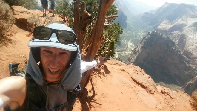
A dirt road takes me a couple of miles to an isolated trailhead with only two other vehicles. A sandy path heads out from here across high desert plateau. Typical scrubby pinyon-juniper forest with sage, yucca, prickly pear, and manzanita, and then some groves of ponderosa pine, tall stately trees with brown and black bark. The plan is to run (with shoes on), but it’s just past noon, the air is hot, and the sun’s beating down. To avoid overheating I alternate running and walking, 100 steps at a time, and periodically take a water break in the shade. After three and one-half miles, I arrive at my destination, Observation Point, which at 6,490 feet is the highest elevation in Zion National Park, and which commands a panoramic view of the Virgin River valley, Zion’s main north-south corridor.
The exposure is startling. I’m looking straight down into the valley. If I slipped over the edge, it seems like my body would land on the valley floor, 2,000 feet below. (Checking the map afterward, I find that Observation Point sits atop a 300-foot rock wall, which rises above a 700-foot talus slope, which sits above sheer cliffs rising a thousand feet from the valley floor. But for the talus slope, which is a little less than a quarter mile wide, it’d be a straight shot down.) 
A crowd of tourists is hanging out, having made the long climb from the visitor center down below, where presumably crowds of people are disembarking from shuttle buses.
I find some shade under a juniper tree growing at the center of Observation Point. Also under the tree, two young ladies eating sandwiches, and three unita chipmunks cavorting in the sand. Crows and a turkey vulture soar past.

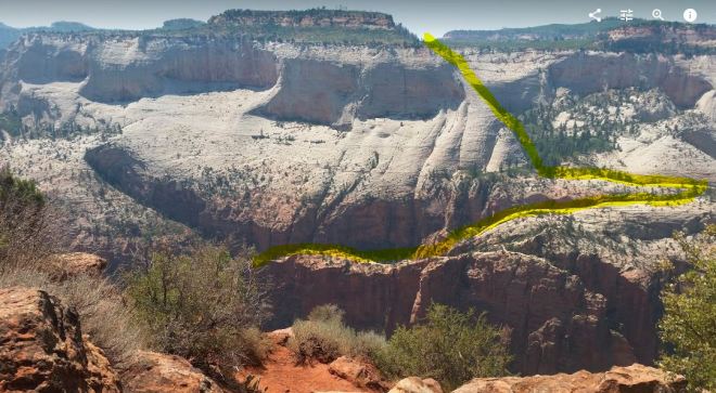
The Virgin River winds off into the distance, the valley floor maybe a half a mile across, the valley walls 2,000 feet tall and nearly perpendicular. What really draws my eye, though, are the cliffs on the far side of a slot canyon just to the north of Observation Point. I find the view rather disturbing.
Now to be clear, it looks very nice atop the plateau, which is covered in green vegetation and sports a few trees (probably the same pinyon-juniper forest and ponderosa groves I experienced on the hike in). In a couple of places, a cap of orange and pink sandstone sticking up like a hat. This is probably what geologists call the Temple Cap Formation, a mix of sandstone and mudstone strata dating back to the Jurassic period, 170-175 million years ago.
The view gets disturbing when you try to trace a route from the plateau down to the valley. Picture yourself standing over there and stepping toward the edge. . . you’re walking across a shelf of white Navajo Sandstone, a strong rock which gives you pretty good traction, but after a short distance it rolls over and plunges straight down. It would only take a few steps to reach the “point of no return” — and even quicker if sand brushes off the rock and gets underfoot.

I’m staring at these cliffs, wondering how on earth could you get down?
You see, there are different ways to look at terrain. You can, like a tourist, admire the pretty colors and interesting shapes, which is not really different from looking at a postcard (some of the visitors on Observation Point have lost interest in the view and are now checking their phones).
Alternatively, you can study the terrain as if you needed to move across it — indeed the eye seems drawn naturally to the task of route-finding — which no doubt for our distant ancestors was on occasion a matter of life and death. Imagine a group of people searching for water or food or fleeing predators or enemies — and they find themselves standing on top of this plateau and staring down 2,000 feet to the valley floor. If that were you, how far would you venture out onto that smooth shelf of Navajo sandstone in search of a route?
I scan the line of cliffs from left to right, all smooth white sandstone rolling off into cliffs hundreds of feet tall. There is no obvious way down — except possibly through a gully. But the back of the gully is hidden by a fold in the rock — it might be a sheer drop, or perhaps it’s something you could climb down.
Let’s suppose we make it down the gully. From here, there’s a steep slope, but dotted with bushes and trees, so you’d have something to grab onto as you made your way down further. But then the trees end, and there’s more white sandstone, not quite as high, but still high enough. However, heading east there’s a groove in the cliffs that looks passable. And after a short distance, it looks like another groove could take you back west and into a section of the cliffs where the Navajo sandstone turns orange (due to higher iron content) and where there’s a pretty deep shelf filled with trees.
I can’t see what happens next, as my view is blocked by brush growing on the rim of Observation Point. I think from here you could make it down into the valley — but if the route were blocked, you’d have to make it all the way back to the top, or you’d be stuck half-way down. As I said, the view is disturbing, when you think through the challenges entailed in moving across this kind of terrain. Maybe it’s just because I’m nervous around exposures.
It’s time to go back. To the south, the trail from the valley floor is cut in the side of sandstone slopes, which here are steep but not perpendicular. Crawling along the trail is a stream of tourists, from here seemingly the size of ants.

Back at Zion Ponderosa Ranch, I change plans and book campsite #4 for the very reasonable price of $15. Not only is the site pleasant, but the ranch has water, bathrooms, showers, laundry, wi-fi, and most important, a coffee bar. I pitch my little tarp, open a can of ravioli for dinner and finish that off with a pickle and a pop-tart. Later that night I wake up to the Milky Way spread across the sky. The next morning, after an espresso, it’s off to Coral Pink Sand Dunes State Park.
Running the Long Path is available on Amazon (Click on the image to check it out)
