En route from Capitol Reef to Bryce Canyon National Park, stopping at the visitor center in Escalante, Utah (population 797) to meet a friend who by coincidence is traveling in the reverse direction, wondering how to spend the afternoon, and the Ranger here has a suggestion: hike in along the Escalante River. It’s not one of the trails marketed to the tourist crowd, in fact it’s not an official trail at all, not shown on maps, and remarkably not even listed in the popular apps. Just be mindful of flash flooding.
My friend arrives, we spend a hour catching up, compare notes on the best hikes in the area, and then resume our separate journeys. I stare at the map on the wall and ponder a place called Death Hollow, whose creek flows into the Escalante about seven miles in.
I find two maps to download on my phone and a vintage topographic map to buy (it’s paper and needs to be folded to fit in a pocket — how quaint!), fill out the necessary back-country permit, lay out gear and pack it up, charge my phone while eating a hamburger and baked beans, and head off to the trailhead, one eye on the clouds massing in the west….
It’s almost 2:00 by the time I set out, which is fine: I’d dawdled over lunch ostensibly to let the phone charge some more but really to avoid the worst of the day’s heat and sun.
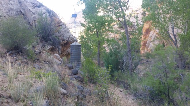
From the trailhead, a jeep road leads down to a fence with a “stile” or gap for hikers to pass through (but not cows), and then a footpath drops into the canyon and crosses the Escalante River where it’s formed from the junction of two small creeks. Through another stile and then I’m surprised to see a solar panel sticking out from the scrub: this is what two of my three maps identify as a “gauging station,” which keeps an eye on the river’s level. Today it’s all of an inch deep — in fact I cross it without getting my trail-running shoes wet — but the Escalante drains a wide area of high desert and during spring run-off and summer monsoon rainstorms, it can swell monstrously and with little warning (the Ranger made sure I understood this).
Speaking of maps, I decide it will be a useful exercise to navigate using the old-fashioned paper map — even though I’ve got two separate map apps running on my phone (as back-up and to see which app is more useful). Every 1/2 mile or so, I stop and look around at the curves in the steep canyon walls and match them to the squiggling contour lines on the paper map. It’s great fun to do so: the sharp-edged sandstone blocks sticking up at one point look like a hatchet, and sure enough I can see that shape on the map, where the contour lines show the handle is only 40-60 feet above the river, while the blade is two or three hundred higher. I come up with special names for several spots: the Hatchet, the Thumb, the Needle, the Two Fingers. The most spectacular feature, however, is the Cave, which seems big enough to play a game of football inside.

The sky has clouded over. Thunder rumbles in the distance, and then a few drops of rain spatter in the sand, so I take shelter in the cave for a few minutes, waiting to see if a storm will develop. The drops tail off. I emerge and move on.
I’m following a soft sandy trail that runs just above the banks, crossing back and forth when the river curves around a sharp bend. From time to time I glance upstream, dutifully checking for the twelve-foot wall of water that might come barreling down through the narrow canyon. It’s hard to imagine, though, with the Escalante in some places petering out completely. I’m walking on slippery wet sand and rounded-stones in the bed itself, following the bootprints of someone who must have been through here recently (with a dog).

Another rumble of thunder. Glancing around, I take note of rock overhangs to shelter from rain and lightning.
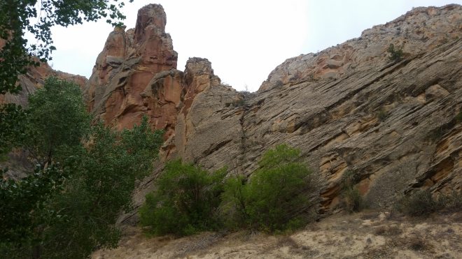
The canyon walls are steep and sheer, hundreds of feet tall, formed of toasted yellow Navajo and orange-red Wingate Sandstone, in some places smooth and polished and in other places shattered and splintered. Next to the river abundant cottonwood trees, some so old their trunks must be 3 or 4 feet wide at the base and bark so deeply furrowed it’s cracking apart. In many places the feathery dark green frond-like branches of tamarisk, sometimes blooming with pink-purple flowers, and there are single-leaved ash, coyote willows, boxelders, big sagebrush, salt bush, scarlet wildflowers (gilla and paintbrush), and plenty of prickly pears.
When going barefoot, the sharp spines of prickly pears require caution, but today I’m wearing shoes, and how easy it seems to go fast! And a steady 2+ MPH pace on sandy trails feels fast! But it’s getting late. 4 PM comes and goes. The map shows what looks like a couple more miles to Death Hollow. I set a turn-around time hack of 6 PM, figuring it gets dark early in these deep, narrow canyons, and also start looking around for places to camp where the vegetation isn’t too thick or prickly.
After five miles of loops and bends, the Escalante straightens out a little, and now I make rapid progress, feeling excited to be nearing the day’s objective. The folded paper map comes out a final time: behind the next sandstone wedge jutting down into the river should lie Death Hollow.
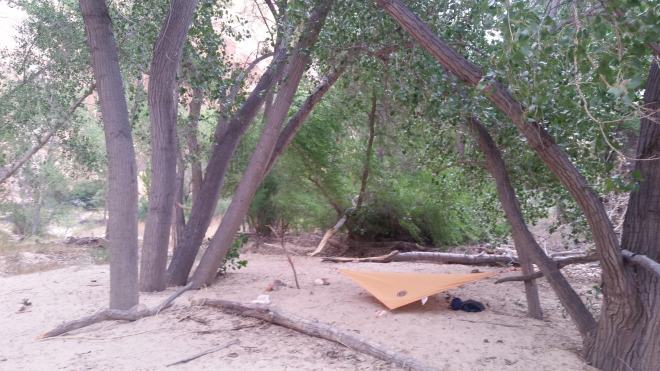
Five minutes later, I’m there, and what a beautiful spot! The Mamie Creek (which flows through Death Hollow) empties into the Escalante beneath steep orange cliffs, and in this little creek is flowing plenty of fresh cool water. To the side of the confluence, a flat bench at least fifty yards long and full of smooth deep clean yellow sand free of vegetation, a log to sit on, a few flat rocks, and all underneath the shade of a dozen stout cottonwoods.
In Desert Solitaire, Edward Abbey describes a five-week period spent camping out deep inside the Grand Canyon: “What did I do during those five weeks in Eden? Nothing. I did nothing. Or nearly nothing.”
And now I have a similar reaction looking at this beautiful sandy shaded bench near the confluence of these two streams. I want nothing more than to hang out and do nothing.
Or nearly nothing. The first priority of work is to lie back and listen to the wind blowing through the cottonwood leaves. I watch the sky, too: clouds have moved in, the sky has turned gray and featureless but for a faint downward curve. This might be rain. It’s moving in toward me, but at the same time the sky’s darkening, turning blue in the west, and the details fade away.
There are some other tasks: string up a light-weight tarp for shelter (and since the wind is kicking up, extra rocks to anchor cords and sticks), heat water for tea (this evening’s dinner), splash about in the river to wash off some of the dust and grit (the paper map falls in and gets soaked), patrol the surroundings (I find a dime in the sand). A few rain drops, surprisingly cold on shoulders and chest, drive me underneath the tarp. From here I peer out at the cliffs across the river: striations mark the wind-driven accumulation of sand beds over the eons, deep cracks run crookedly from bottom to top, the rocks are glowing orange and splotched with dark varnish, smooth bands of mauve pour down from the top.
The sky darkens, the wind subsides, there’s no rain. The cottonwood branches reach overhead, gradually darkening against the luminescent gray. I pick out a single leaf and observe how it shakes back and forth by an inch or so, and sometimes flutters side to side (like their relatives the trembling aspens, cottonwood leaves hang on flexible stalks). But when the wind gusts, the narrow branch from which this leaf and a hundred of its neighbors depends shakes back and forth — and now the leaf jerks six inches or a foot to the side, up, down. If you could trace the tip of that leaf over time, you would find a strange cursive script spelling out the interaction of wind, wood, a single leaf, and its many peers.
A drowsy vision occurs to me: suppose after a long, harrowing journey, you arrived at a place like this, a place so beautiful that you wanted to do nothing but be here and let time run its course. Picture yourself crouching by the log, fitting together a stove, heating water for tea. There’s a sound in the brush — you glance over your shoulder, get up to look — but nothing’s there — maybe you imagined it, maybe it was a memory. Sitting down again you knock a bottle over, and water spills into the sand. Time goes by, and not just 24 hours or even 5 weeks, but many, many years. Now you are lying under the tarp, so old that you can barely pull the zipper on the sleeping bag against the cool air. Your last sight is of a sign, one you long hoped to see, a sign portending rebirth beyond time and consciousness: one day we will become true children of the stars, cognizant of and enraptured by Earth’s beauty.
The next morning, I’m up before dawn. Tarp comes down in the dark, another pot of tea is heated, shoes get tied to pack. Soon I’m splashing along the Escalante’s soft sandy bottom, where the water may very well be running an inch or two higher than the day before — and then speeding along the sandy trails in the cool morning air, passing Needle, Cave, Hatchet, gauging station and through the two stiles, and back out once again into the desert sun.
Running the Long Path is available on Amazon (Click on the image to check it out)

