What caught my attention after the four-hour drive from Salt Lake City, once I’d reached Moab and was motoring along Route 191 through the center of town, passing all those restaurants, curiosity shops, and tour operators, was the line of mountains rising in the southeast.
The next morning saw me hiking out to the Delicate Arch in Arches National Park (isn’t this every tourist’s first stop?) — when here were those mountains again, with a mushroom cloud bubbling above, as if the peaks had pierced the winds and cast the atmosphere into turbulence.
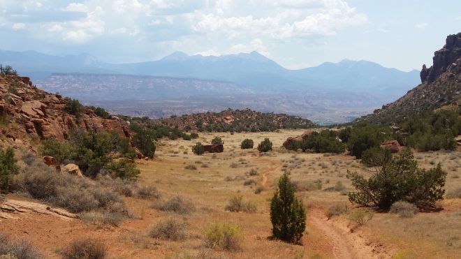
And then a day later, from the high point in Hidden Valley, here they were once again, gazing at me with curiosity across thirty-five miles of hot sand and haze.

A bartender tells me these are the La Sal Mountains. Some quick research identifies Mt. Peale (12,761 feet) as the highest. A handful of trip reports and GPS tracks are available online — everything needed to plan a summit attempt — yet I hesitate. Several risk factors argue for caution: the harsh environment at altitude, the potential for afternoon thunderstorms, remote trailhead, unmarked trails, reports of steep scree fields.
But after a few days hiking and running around Moab, my confidence begins creeping upwards. The weather forecast clears. I stay up late studying the trip reports, go to bed feeling unsure, but the next morning I send an email to my wife alerting her of my plans (so that someone will know) and head out.
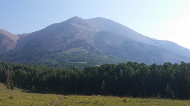
Thirty miles of desert highway takes me around to Mount Peale’s southern flank, and there it is, Utah’s second-most prominent peak, bulging in the haze.

A 9-mile dirt and gravel road leads up through an aspen forest, a strange sight to a northeasterner like me, full of stout trees with ghostly smooth white bark. A young mule deer bounds across the road with a stiff four-legged hop — not something that white-tailed deer do back home.
Arriving at La Sal Pass at 10,200 feet in elevation, I pull into the trailhead, take some deep breaths, and shoulder my pack. Due to the various risk factors, not the least of which is my lack of familiarity with this area, the load-out is conservative: 3 liters water, goretex jacket and pants, warm clothing, headlamp and flashlight and extra batteries, a light-weight tarp for emergency shelter, trekking poles, phone with route and two map layers downloaded, battery charger, desert hat and arm sleeves, first aid kit, compass, jack knife, extra cordage. No food for a day hike. Altogether about fifteen pounds.
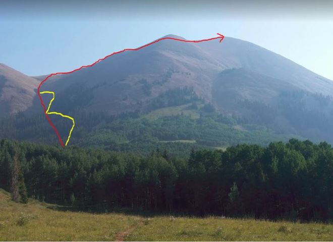
Mt. Peale looms above, displaying almost every step of the three-mile route to the summit, including a couloir (steep gully) that leads up to a saddle on the ridge. Reviewing the risk factors, I determine my threshold for aborting the summit attempt is “low,” power up my personal locator beacon and activate its tracking feature, and move out — focused for now on nothing more than completing the first mile.
A dirt trail heads out across a broad meadow, enters aspen forest, reaches a jeep trail. One of the trip reports advised: “Immediately after crossing this road, find a suitable break in the trees to head off trail and uphill.” Soon I’m weaving between aspens and some conifers, too, when to my surprise, checking the cellphone map app after a few minutes, I’ve already diverged significantly from the suggested route, which veers left toward the couloir. Taking the most direct route up is a standard bushwhacking procedure for the Catskills — and maybe I’m following old habits — but here the slope is getting uncomfortably steep. Above me, tongues of scree pour down between the trees.
To reach the couloir, I’ll need to stop moving upwards and start contouring (i.e., moving sideways) across the steep and unstable slope — something the Catskills have taught me to avoid at all costs — but now there’s no choice. The scree consists of “pancake-shaped” rocks, and while they’re smooth and not uncomfortable to step upon, they tilt unpredictably — enough to throw my balance off. I’m moving very slowly, practically in a crouch, uphill hand holding onto rocks for balance.

It’s a relief to gain the couloir and find what appears to be an unmarked trail on its shoulder. Above me is the last stand of trees on the mountain — above them relentless unending scree. As per the trip report I’m supposed to work around to the left. But this route takes me back out of the couloir and once again straight upwards. The rocks dislodge easily here, they can’t be trusted for hand or footholds. Even worse are patches of open dirt and gravel, where everything scatters. Soon I’m crawling on all fours, out of breath, feeling increasingly uncomfortable.
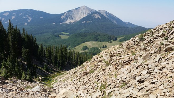
Up ahead, a flat shelf. I pull myself in and collapse against the rocks, afraid to look down. Recalling the “low” threshold, I authorize myself to abort the summit attempt, justifying the decision on my fear of heights. But what to do? Descending the way I came seems very unappealing. A better bet would be to move sideways back into the couloir, which is both the suggested route to the summit and the safest line of retreat. Lucky me: here’s a second opportunity to contour across steep and unstable terrain. I drink some water, take some deep breaths, and take a quick peak downhill: to the south, the meadows and aspen forests I’d passed through, and behind them the La Sal Pass now 2.5 miles away and 1,500 feet below, and further in the distance the 11,798-foot summit of South Mountain.

While the rocks aren’t bothering my feet, going barefoot isn’t giving me enough confidence for this environment; it’s one psychological stressor too many. On go a pair of trusty Terraflex trail-running shoes, and I also pull out the trekking poles. Suddenly, walking across the scree is easy.

Once back in the couloir, I stick to it until it’s time to head up for the saddle, but even so this slope is so much easier than what I’ve just been dealing with, indeed there are even stretches of grass interspersed among the rocks. Suddenly, movement up ahead: five or six mountain goats picking their way across the ridge, flowing gracefully across the scree, snowy-white muscular beasts, they keep their distance and vanish over the far edge.

The crest of the ridge offers sweeping views into the huge valleys on either side, but it’s wide enough to keep me from fretting about exposure, even when the winds gust. Moving steadily now towards Mt. Peale a half-mile away, stepping and breathing, rocks grinding and clinking underfoot.

At the summit finally, I shelter in a ring of rocks that’s been constructed by past visitors. Order of work: put on sweater, reapply sunscreen, drink. I look up into the cloudless sky and feel a tinge of vertigo. A bird slices thought the air, feathers hissing.
To the west, Mount Tukunikivatz. Edward Abbey described his ascent of this peak in Desert Solitaire. I hope to climb it, too, but not today.


On the descent, I stick faithfully to the couloir: it’s like walking down a long sweeping staircase, albeit with some loose steps. This has been a lesson in geometry: the ridge takes you directly to the summit, whereas the couloir zigs off to the left towards the saddle and then you zag right to the summit, in other words, it’s a longer distance to gain the same elevation so the grade has to be more moderate. (I’m not the only one who appreciates this route: tufts of snowy white woolly fur on some branches)

Half-way down the couloir is choked with deadfall, but here some cairns lead me off to the side and onto a dirt path which morphs into a jeep trail — the same the one I’d crossed earlier, not knowing it connects straight to the couloir.
Walking back now through the meadows, swarms of grasshoppers snapping and buzzing — an orange butterfly flutters off each time I get close and then changes course and alights on a showy goldeneye by my feet – endless blue daisies and yellow goldenrods — and finally passing out through the shimmering aspen, leaves dancing in the mountain breeze — and Mount Peale’s massive scree-covered slopes filling up the sky and beaming in the light.


Running the Long Path is available on Amazon (Click on the image to check it out)

Great post!
LikeLiked by 1 person
Check out my blog when you get the chance
LikeLike
[…] The trail to Hidden Valley starts with a series of steep switchbacks climbing 600 feet up the side of a plateau on the south side of Moab. Once at the top, I marvel at the pale green valley that opens up, dotted with sage brush, green ephedra, black brush, prickly pear, yucca, salt bush, and winterfat. Looking back the way I came, here are the 12,000-foot La Sal Mountains staring directly at me across thirty-five miles of desert. How curious that Hidden Valley is oriented directly towards these mountains. […]
LikeLike
That goat is pretty cool!
LikeLiked by 1 person
[…] lenticular cloud that had formed above a ridge, while in Utah a mushroom cloud bubbled above Mt. Peale so massive that it dwarfed the […]
LikeLike