The forecast kept me out of the mountains, I just didn’t have the heart to face freezing rain. Where was Spring?
The next day dawned sunny, if not warm, so it was into the car and off to the north, time to get back to work on the Grid. Along the way I noticed the sky was clear overhead, but cloudy along the horizon — upon reflection, it seemed this must always be the case, because when you look at a low angle, you see the mass of all those clouds and not the gaps between them.
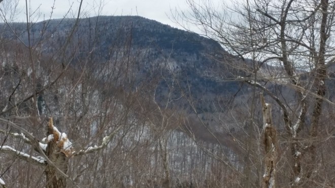
Good spirits lasted for a little while until when cresting a rise on the highway, suddenly there were the Catskills right in front, with Plateau Mountain in particular stretching out as if with open arms to welcome, embrace, and crush me to pieces against its frosty white chest. White not being the color of clear slopes and clean trails, like I’d been hoping for, but hardly a surprise, either, since the mountains create their own weather.
Pulling into the trailhead now, the valley socked in with a high cloud layer and snow dappling the ground…
It’s just a little snow, so boots and snowshoes stay in the car, spikes are carried just in case, and I head out in trail-running shoes. The first leg of today’s hike will be Rusk Mountain, but not the standard route from the Spruceton horse trail, which I’ve done 5 times, and not coming in from East Rusk, which I’ve done twice. Rather, the plan is to bushwhack northward up Evergreen Mountain, and then turn east and ridge-walk for a couple of miles to Rusk’s summit, thus arriving there from a new direction.
The West Kill stream immediately presents itself as an obstacle: there won’t be any getting across with dry feet. However, this problem is quickly solved as the map shows a bridge 1/4 mile up the road, with access to the state forest preserve on the far side, and soon I’m marching up a very moderate slope (16% grade I would calculate later) through relatively open forest dotted with old stone walls. What a thrill to be exploring a new route, and what a joy to encounter such pleasant terrain! Except for skirting fallen branches, the walking is easy.
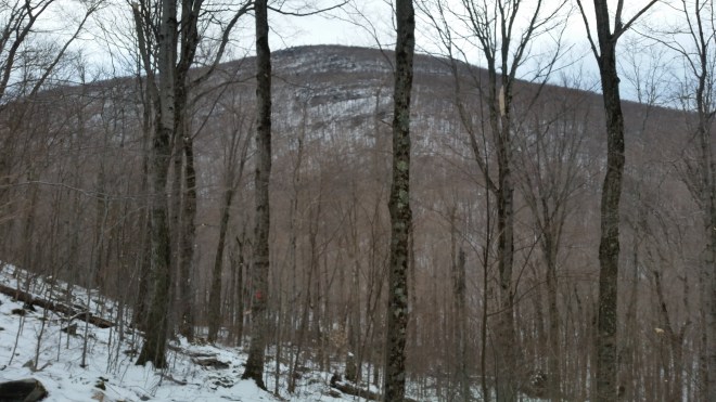
And then the slope steepens, of course, and now the grade is almost 40%, but it’s still walking, just shorter steps and a slower pace. There’s 1-2″ of fresh snow blanketing the ground, but not enough to slow me down. Eventually the slope levels off again, giving Evergreen Mountain, like many Catskill peaks, a kind of “S” shape, with a moderate base and top, and a more abrupt section in the middle. I pass a tall and luxurious-looking hunting stand and then reach a big sandstone block guarding the final approach to the summit. There’s an easy walk-around, but how can one resist squeezing up through the rocks? Once on top, I turn to the south and peer across the valley at St. Anne’s Peak and North Dome Mountain, and the steep notch between them. Several miles further south, visible through that notch, there’s a tall and imposing ridge, glimmering blue in a beam of distant sunlight. This is unmistakably Panther Mountain, upon whose summit ledge I’d stood a few days ago and looked out this way, picking out St. Anne’s Peak and North Dome, and if I’d followed the line a little further, I’d have seen Evergreen, too.


The shimmering blue light on Panther’s upper slopes catches my eye — it’s as if Panther’s stature as one of the Catskills’ tallest mountains warrants special treatment from the clouds — they back off just a little and allow some light through. The rest of the scene is gray.
Time to turn to the right and start moving east. I descend a modest slope through more open forest, the snow cover making it easy to see the lay of the land. It’s a gradual downhill for a mile until the saddle between Evergreen and Rusk, and then the slope turns gradually back up, and despite the dim gray day, I’m enjoying the new route and feeling a sense of momentum.
The terrain steepens on the way to Rusk’s summit, and once above 3,400 feet it’s into the more crowded boreal forest, where healthy-looking specimens of fir and spruce force a few detours, or twisted branches of yellow birch or mountain ash block the way — but it’s not bad compared to the really thick stuff I’ve encountered on Friday, Rocky, the shoulder of Slide Mountain, and other places. The trees are strong and good-looking, like young athletes, and many of them are wearing their finest jewelry, which is to say they’re adorned with beautiful specimens of moss and lichen. A spruce is festooned with clumps of beard lichen, some of which hang a foot long. Where branches get plenty of light, they’re covered in swirling gray ornaments — minute pewter filigree of hooded tube lichen, thin plates of shield lichen, wavy crusted lobes of Punctelia caesan, pale green tufts and tendrils of antler lichen and boreal oakmoss.


To be fair to the lichens, they don’t passively hang in place like ornaments, rather they’re racing and competing with each other, spreading across every available square inch of tree bark to position themselves for sunlight and moisture. While they’re slow-growing creatures by our standards, they’re really quite innovative and aggressive: some wrap themselves around the smallest twigs, others sprout upwards or hang down — all different strategies for grabbing that precious sunlight. Sometimes when I feel the crush and pressure of modern life, the incessant competition, advertising, debating, conversing, complaining, lecturing, shouting, I reflect that lichens have it no easier.
Rusk is reached in due course. So far, it’s been a pleasant five miles through the woods, and legs and ankles are feeling as good as they have in a long time. Now it’s time to descend into the valley, and I have a special plan, because this side of Rusk is painfully steep. Part of the challenge is that the direct azimuth from the summit to the Spruceton horse trail, which is the route most people take, plunges down a ravine and cuts across steep slopes. Today I’ll keep going past Rusk’s summit for a short distance and then turn down, aiming to stay on the crest of a faint spur and keep off the steeper sides. The plan works beautifully: checking the map afterwards, this maneuver brings the average grade down from 36% to 30% — just enough to take off some of the sting. On the way down I check the compass a few times until I discover I can orient by looking out at Diamond Notch across the valley. Off in the distance to the left, the firetower on Hunter’s summit is barely visible, looking no thicker than a twig.
Once down on the trail, an easy stroll brings me to the base of West Kill Mountain, where the plan is to plunge back into the woods and bushwhack straight up the mountain’s shoulder. But first I’ve got to cross the West Kill stream, the same one that forced the detour early on, but this time there’s a fallen tree that reaches half-way across the flowing water. A few rocks get tossed in for stepping stones, and this works until a malfeasant stone tilts when I step onto it, with the result that one foot gets wet. No big deal, once on the other side I stop, unlace, wring the water out of the sock, and continue on.
This slope faces north, and it’s covered in snow from the base. Spruce and fir trees are growing on the far side of the West Kill, and by the time I reach 2,500 feet, it feels like the boreal zone which started on Rusk almost 1,000 feet higher. At first moderate, the slope steepens to around a 30% grade, and there are a few ledges which require grabbing onto roots or branches or slender saplings, but mostly it’s like being on a stairmaster, just lots of small steps, and the good news is ankles and knees are feeling good, and I’m not in any way tired, just a little hungry (no breakfast or lunch today). Nonetheless, my enthusiasm is starting to flag. What I’m really hungry for is light — light and a patch of blue sky. It’s been unremittingly grim and gray since the start, there hasn’t been a single flash of sunlight. I was expecting Spring, I was not expecting to keep battling winter for so long.
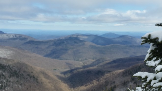
Doesn’t really matter, though, as there’s nothing to do and nowhere to go except up. In due course I pop out on the trail on top of Westkill and a few steps later arrive at the Buck Ridge Lookout. And here, finally, is Spring: to the south wonderful blue skies stretching out to the horizon, endless plains warm brown and free of snow spreading out below and into the distance, everything dancing in beautiful sunlight. But that’s all looking south into the Hudson Valley — to the north, a thick layer of dirty gray fog hurries across the sky, moving to shield the mountains from the sun and preserve their special climate of snow and shadow. The cloud layer passes over the top of the Blackhead Range, the three sentinels which brood over the northern escarpment, and perhaps they are responsible for this weather, because the airflow must rise three thousand feet to get over their shoulders, and as the air rises, its moisture condenses into cloud…..Suddenly, to the east, a flash of brilliant white: the rime-crusted firetower on Hunter’s summit gets lit up by a probing sunbeam, and then the light moves across the snowy fir and spruce nearby. I stand and stare at all of this for a long time, gulping in the color and light, trying to drink enough of it to sustain me on the final leg of this journey.

Back into the shadows on West Kill’s summit ridge, where winter still has the upper hand. The problem now is the trail, five miles of it back to the parking area, and not unexpectedly, it’s a snowy-icy-crusty mess, with plenty of “postholes” where people stepped in slush that subsequently refroze, and some scrambles up and down icy ledges, too. I worry about stepping wrong and slipping and falling or tweaking ankles and knees, or not getting back to the car until after dark (although I have lights), but really the frustration is that after struggling all winter long to move through snow and ice, it’s spring now, and supposed to be time to resume that quick, confident, rhythmic gait that runners in particular crave — but that’s not going to happen today.
There’s nothing to do but step slowly and place each foot carefully — and where the trail gets especially rough I howl to myself with frustration — and where the passage is a little more reasonable my thoughts wander and time trickles by.
I’ve gotten into the habit of equating the mountains with joy and exhilaration, and contrasting this with certain grim aspects of modern sedentary life. But this isn’t right. The mountains are a source not only of joy, but also of pain and misery — and especially so in winter. Which is why over the centuries people have voted with their feet and generally moved from mountains and forests into the cities, which is where the best prospects of joy are to be found for most people.
John Burroughs used to say, “I got to Nature to be healed and soothed and to have my senses put in tune.” Or put differently, some of us go back to the mountains to recalibrate, that is, reacquaint ourselves with the full range of experiences and feelings, to make sure that sedentary life hasn’t left us comfortable, complacent, and one-dimensional.
A few years ago I thought I heard the mountains calling, and initially I thought they would teach me to run through the forests with joy and exhilaration — but it now seems they had a more comprehensive lesson plan in mind, one that would include the aggravation and dismay of trudging through a dim gray landscape with fresh snow and icy trails. And I will graduate from this course of study, perhaps, when I can return to modern sedentary life with expectations for the same range of experiences as I’ve found in the mountains. That is, I think, what Panther, Hunter, and the Blackhead Range were trying to say today.
As I move across the top of Westkill, there are some glimpses of the southern Catskills, dimly blue in the fading light, and from this angle Cornell and Wittenberg appear especially dramatic, a pair of standing waves. Descending into the Mink Hole Notch, North Dome rears above me, incredibly steep, severe, uncompromising. These mountains are still on my list for April.

By the time I reach the thruway, headed for home, it’s dark. But the sky still has some dim color, and it’s the same blue I’d seen earlier, just darker, with a few soft gray clouds stretching across.

Running the Long Path is available on Amazon (Click on the image to check it out)

[…] and afterwards we clean up some ancient beer cans and gas canisters I’d spotted when bushwhacking Westkill in […]
LikeLike