With 232 Catskill climbs under my belt, I’m 55% of the way through the Grid. I wasn’t able to put much of a dent in September, only 43% complete — there were too many conflicts, like the SRT Race and and a trip to the Adirondacks — but October is coming together nicely with 74% done and plenty of time left in the month.
Here are a few notes from recent hikes, the purpose being to document the experiences before they’re forgotten….
Devils’ Path — September 23, 24
The goal is to link up with Long Path thru-hikers Scott Weiss and Heather Housekeeper.
Odie and I arrive at the Roaring Kill parking area mid-afternoon on the 23rd, later than planned, and then on the hike in miss an intersection and go a half-mile out of the way. For all my experience in the Catskills, and for all the technology I carry, it’s amazing how easy it is to go the wrong way. And then — once back on course we reach a viewpoint, and now I’m wandering in circles looking for where the path goes next. Turns out it doubles back on itself quite sharply. I blame sloppy blazing.
We arrive in Mink Hollow around 4:30 PM and walk up to the lean-to looking for Scott and Heather and then inspect nearby campsites shouting their names. I didn’t know for sure they’d be here, it was my best estimate. We head up toward Plateau, which we need to climb anyway, and here they are heading down.
After dinner we hang out and trade stories. Heather is a real long-distance trail veteran, having hiked the Appalachian Trail, the Finger Lakes Trail, and the Mountain to Coast trail in North Carolina. Scott is a talented musician, with a background that includes hiking, bushwhacking, and spiritual training with Native American tribes. They both study the herbal, nutritional, and medicinal properties of native plants, and Heather’s written two books on the subject.
The next morning the four of us climb Sugar Loaf. It’s hot, and there’s no water on the trail. I’m carrying 1/2 liter of water and take a swallow but the rest goes to Odie.
Heather points out wood sorrel and white snakeroot. We discuss the fragrances of balsam fir and red spruce, and how to pick and cook nettle.
Next is Twin Mountain. There’s a steep scramble with no visible work-around. Odie needs some help. Once we’re up, I realize that getting him down will be difficult (I could lower him down using his leash, but I’m worried that his harness isn’t secure enough, he could fall out). I’d planned to say goodbye to Scott and Heather on the western summit of Twin and then head back to the car, but having passed this scramble we’re now committed to go down the other side, which will leave us with a long walk back to the car.
It’s hot and dry. We pass a stream with a trickle of water and Odie takes a drink, but instead of filtering water, I just soldier on.
We reach the paved road, there are two miles to go. I’m now extremely thirsty, having had almost nothing to drink all day. A little fatigued, too, not having eaten anything in almost thirty hours.
I’m looking at the houses we pass, wondering is there someone I could ask for a drink of water? I’m looking at the passing cars, wondering would someone offer us a lift? My sore ankle tendon is starting to hurt.
A woman is walking her dog. She greets us. Her name is Rose. She lives nearby. Would we like some water? Do we need a ride back to our car? I decline, we’re almost there. But Thank You, Rose!
Scott and Heather are fun people with big smiles. Odie and I hope to hike with them again. Later on I learn that they’ve given Odie an official trail name: “Mountain Goat.” They were impressed by his agility, how he found the most efficient routes up through the scrambles. They gave me a trail name, too, I’m “Flash.”

Wittenberg — September 30
There’s time for one last September hike. Odie and I head off for Wittenberg. The comedy of errors continues: once on the road, I realize I’ve forgotten the new insurance ID card that just arrived in the mail (better not get pulled over). Upon arrival, when I try to pay for parking, it seems I’ve forgotten my wallet.
The trail out of Woodland Valley is steep, and then it levels out under a grove of hemlocks and circles around to the eastern shoulder of the mountain, where it joins the Long Path. After that it’s ledge after ledge, a mile-long scramble to the summit. Which is socked in: nothing but gray.
We pass many hikers coming and going. Mountain Goat receives compliments for his grace navigating the ledges (although I have to lift him up in a couple of places).
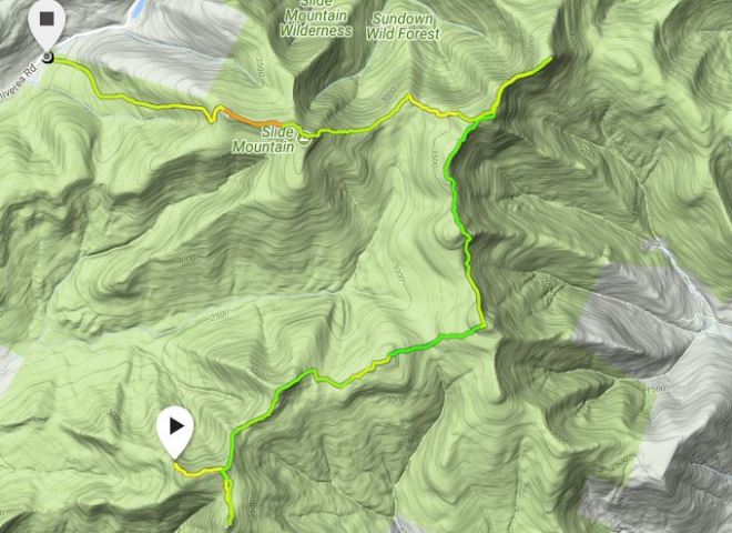
The Nine – October 7
The 3-day Columbus Day weekend will give me the chance to put a big dent in the October Grid. The goal is the Nine — a circuit that includes Table, Peekamoose, Lone, Rocky, Balsam Cap, Friday, Cornell, Wittenberg, and Slide. I attempted (unsuccessfully) to complete the Nine barefoot a year ago — this time I’ll get it done, scratch that item off the bucket list, and then do some more the next day.
Arriving late afternoon, I find the trails are extremely dry. This means, hard-packed — the worst conditions for a beginner barefooter like myself, because all the grit, gravel, and rocks sit on top of hard-pan. Even when damp, the trails around Slide are particularly difficult because the sandstone contains conglomerate which breaks apart into sharp pieces with lots of grit, not the smooth weathered blue or brown flagstones you see elsewhere in the Cats. Soon I’m groaning with aggravation, but being stubborn refuse to cede my purpose, even though Vibram Five Fingers are hanging from my waist strap.
Eventually the trail turns uphill, and the going gets a little easier. I arrive around 10:00 PM at the Table Mountain Lean-to which is unoccupied, although others show up later.
The next morning I’m up at dawn, but the plan to barefoot the Nine goes out the window. Sometimes it’s better to be flexible rather than stubborn.
In flood time you can see how some trees bend,
And because they bend, even their twigs are safe,
While stubborn trees are torn up, roots and all.— Sophocles, Antigone
It’s off to the the nearby spring to refill my 1/2 liter water bottle. The spring is barely dripping.
No goals, no pressure, I take my time and focus on navigating through forest without official trails.
Following the precise crest of Table’s shoulder, a well-used social trail takes me down into the next saddle and then up to Lone, an easy walk with a single row of ledges and a chute between the cliffs that’s easy to find.
Then it’s down into the next saddle, where you need to turn to the east. I turn a little late, slide 1/4 mile too far to the north, and then pass by a little below the saddle.
Thoreau wrote in Walden:
In any weather, at any hour of the day or night, I have been anxious to improve the nick of time, and notch it on my stick too; to stand on the meeting of two eternities, the past and future, which is precisely the present moment; to toe that line.
Toeing the line is a key concept in bushwhacking: you want to stay right on the crest of the ridge that connects the peaks, because it’s the most direct route from one high point to another. It’s like how a race car driver has to follow an optimal line through the curves. And there’s another line to toe, although you can’t see it: going at just the right speed, obviously critical for the driver entering a turn. Similarly on this pathless journey between peaks, there’s an optimal speed for me, too, one that balances my desire to move purposefully against the challenges inherent in such rugged terrain.
Now it’s the long walk up Rocky, at first through a big clearing before dipping back into the woods, and then a social trail appears, flickers out, returns, and soon enough I’m at the summit.
Next it’s down a much steeper slope — and here there’s a pretty sizable cliff I can’t get down. I double back and find a way through — I’ve been here and done this before, as I recall from an unsuccessful winter attempt on the Nine in January 2016. The saddle before Balsam Cap is dense with fir saplings, and then it’s steeply uphill through abundant rock ledges.
From the top of Balsam Cap, you pivot north, hugging the clifftops on the eastern face of the ridge, drop into the next saddle, and now there’s a choice: straight up to Friday, or slink around to the east at the base of tall cliffs, and then turn up, access a chute up the side of the cliff, and eventually emerge onto the summit.
There’s one more saddle, a small bump on the ridge, lots of dense fir thickets now — some of the worst — and finally I’m on the trail once again, just off to the side of Cornell’s summit.
Time for some sausage, cheese, and tea heated over a can of sterno — it’s been 24 hours since my last meal. Off in the distance, clouds shimmer above the Ashokan Reservoir, and maples are glowing yellow and red.
On to Wittenberg, then back past Cornell again, down into the saddle. I’m tempted to pitch my tent here, but is there water? I scramble up the 800 feet to the summit of Slide, stopping at the always-reliable spring here, but it’s totally dry. A long day on not very much water. If I pitch camp up here, it will be a thirsty night.
Instead I head down. It’s dark when I reach a primitive campsite marked on the map. There’s lot of people here. Is there water? They don’t know. I keep going.
The trail is endless downhill with lots of rocks. Even with the VFFs my feet are sore. There’s no way to pick up rhythm, no matter what you’re wearing. Once again, I’m groaning in aggravation at the rocks, the slow pace, out of water, and no special goal except for this to be over with — at the same time the part of me that’s ostensibly in charge is monitoring the situation, and despite thirst and sore feet there’s nothing really wrong. The groaning is getting wearisome to listen to — “SHUT UP” I finally shout at myself
There’s eventually a feeble trickle across the trail, but no place to camp. This is pointless, I head for the car and drive off to a local restaurant where I sit outside and enjoy the beautiful warm evening.
Windham – October 9
A day off to recover from the Nine, and now with Odie we’re back en route to the northern Catskills, driving through Tannersville, making the familiar right at the old stone church — and now we’re driving through Tannersville once again. Evidently it’s supposed to be a left at the church.
Soon enough we arrive at the base of Windham. It’s a mountain Odie and I know well and have been up recently. The forecast called for heavy rain all day, and this must have scared everyone from the trail. We pass an empty lean-to, unusual for a holiday weekend.
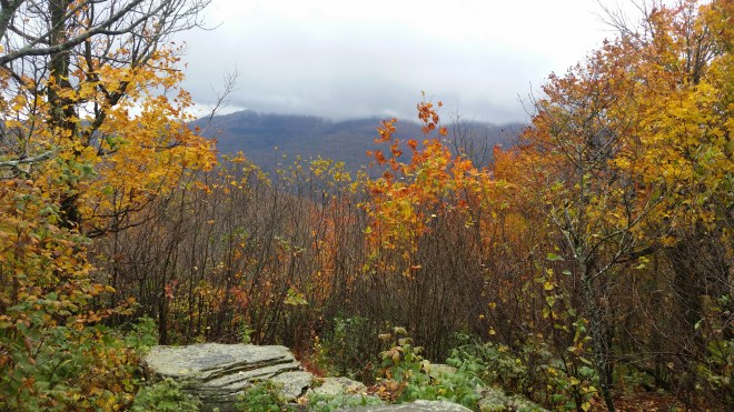
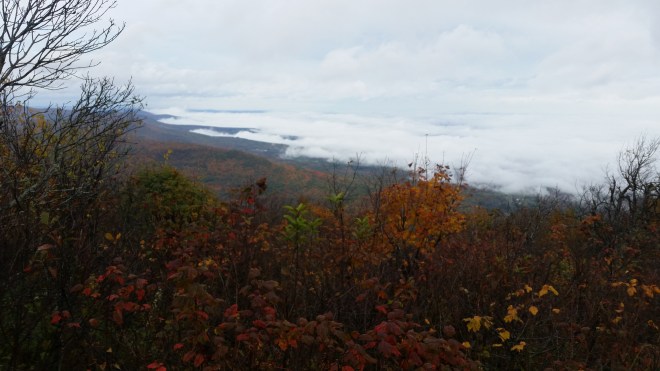
The rain holds off, though, and an easy saunter takes us to the top. We look south for our old friends, the Blackhead Range (Black Dome, Blackhead, and Thomas Cole mountains), but find a line of gray cloud is staring back at us, having advanced across and obscured the summits and no doubt getting ready to move our way.
A little further on we come to another vantage, this one facing north, and clouds are streaming by on the left and on the right and converging into the distance. Down below fog is lapping against the foothills, while off to the northeast three or four ridgetops poke out of the milky sea like islands. The shoulder of a cloud glints with sunlight that’s passed through a hidden rent in the ceiling.
On the way back, the winds find us. They thunder through the forest, whipping birch trees back and forth. I walk along with one hand holding onto my hat.
The winds seem so purposeful, they gust around with such determination. But because they’re part of blind nature, we don’t ascribe purpose to them, rather we describe them as “equilibrating” high and low pressure zones. But people are part of nature, too, so where does our purpose come from? Maybe all of our effort and movement is just another form of equilibration. I think back to the Nine and conclude I did a good job blowing around the circuit, gusting, rushing, soughing, moaning, and swirling a few leaves, too.

Running the Long Path is available on Amazon

