With a week off from work and the weather turning unseasonably warm for late September, I decided to forsake the Catskills and head to the Adirondacks, with the goal of climbing a few more of the 46 high peaks barefoot. Three days and almost thirty miles later, I returned with six peaks bagged, bringing the total to 17, and an even deeper appreciation for this lush, wet, rugged, steep, fragrant, unnerving, spectacular wilderness.
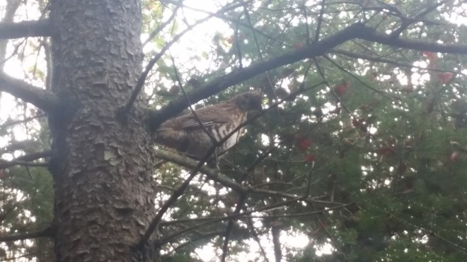
Arriving at the Adirondack Loj parking area around 8 AM, I headed off on a seven-mile hike round the backside of Mt. Marcy toward my first objective, Cliff Mountain. It was just one foot after another, a steady, slow, plodding pace, at first along a soft dirt path. I flushed a grouse, but instead of vanishing into the forest, the bird jumped onto a branch above my head. I’ve been startled by the rush of beating wings so many times in the past, but never saw one of these birds stationary and so close, and now I just stared in astonishment.
After this excitement, it was back to slow, steady, plodding progress. The soft dirt path soon degenerated into the more typical mix of rocks, boulders, mud, and wooden planks that you find in this rugged, wet environment. In parts it was very wet.

The Adirondack mountains are covered in dense boreal forest consisting largely of fir, spruce, cedar, paper birch, and maple. The conifers have the fresh smell we associate with pine trees, but if you crush the needles you’ll find the spruce have a sweet citrus scent, the fir smell a little musky, and the cedars are redolent of orange marmalade. As I walked along on this unnaturally warm day, the forest’s fragrance reminded me of butterscotch and seemed strongest where the trees stood baking in the sun.
As much as I was enjoying the forest, however, I was careful to check map and GPS at every intersection, as this was unfamiliar territory for me, and deep in the back country, with no quick exit. After seven miles I was delighted to find a cairn marking the unofficial trail to Cliff Mountain.
Unofficial trails in the Adirondacks often have as many improvements as the formally designated routes, but they aren’t marked with blazes, and sometimes there are surprises. The path to Cliff Mountain started out in a bog, and while logs and planks had been thrown out as a bridge across the mud, much of the wood had rotted or settled beneath the surface. I missed a step and sunk mid-way to my knees.

A pair of hikers descending from Cliff warned me of ledges. “Grab onto the trees,” they advised. A little while later I encountered the ledges, and there were a couple of spots which made me nervous. These weren’t ledges, I realized, they were small cliffs, and suddenly I understood where the mountain got its name.

I didn’t stay long at the summit. I was thirsty and a little worried about descending those cliffs. Mt. Colden reared above to the northwest, its eastern face scarred by long rock slides.

Somehow the cliffs felt easier on the way down — bare feet have good traction on rocks — and soon I’d arrived at the lean-to where I planned to spend the night. It was occupied, so I set up camp nearby and walked down to the Opalescent Brook to filter water and drink, and while doing so discovered a small patch of blueberries growing on the bank, a surprise so late in the season, and a treat.
The next morning, my first objective was Mt. Redfield, a nearby mountain situated along another unofficial trail. The path initially paralleled the Opalescent Brook through an extraordinary tangle of roots and fallen trees.


Then the trail turned steeply uphill and followed another creek, the pathway hugging the bank and sometimes stepping through rocks and boulders in the streambed. From the summit of Redfield, Mt. Marcy towered in the distance.

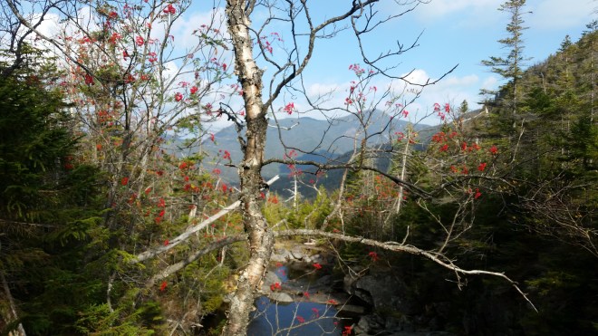
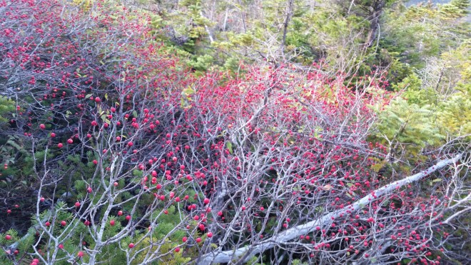
On the return from Redfield, the sun broke through the morning mists and lit up the clusters of red berries hanging from mountain ash trees. These berries are very tart, but the sour taste was invigorating, and I nibbled one or two berries whenever a cluster was in reach.

Almost back to the lean-to, I accidentally turned onto the trail to Cliff — I quickly recognized the error, but not before reaching the muddy bog where this time I missed a step and sunk all the way to my knees.
Next on the itinerary was Gray Mountain, but as I made my way slowly along the trail, the mental stress of this expedition began to catch up. To start with, for those of us who’ve spent most of our lives strolling on sidewalks, it takes great concentration to navigate the rocks and roots and mud that make up Adirondack trails — and especially so when barefoot, as each step must be placed with deliberation. Also, having been humbled by cliffs, mud pits, and roots, I was a little nervous about what tricks Gray might toss my way, as this was yet another unofficial trail. Finally, with the weather unseasonably warm, I kept running out of water. So now my mood was a little sour.
Gray immediately presented me with a pair of cliffs which I negotiated successfully but not with great confidence — and then I began to worry that the weather would change — having heard reports of rain from another hiker — and didn’t unusually warm temperatures presage a storm? I kept moving along but at the same time began to draw up contingency plans: I’d skip the next mountain for sure — and maybe I could get out of the back country and on my way back to the trailhead today. But then I realized to do so would require getting up and over the shoulder of Marcy and then it was several miles until the first lean-to. This didn’t seem feasible. I was stuck.
At the summit, I glanced around nervously. Marcy stood impassively to the north, unmoved by my plight, while rows of sky-blue mountains rolled off into the distance. 
On the way down, I found “work-arounds” or side trails that avoided those two cliffs, and my mood improved. Soon I was back on the main trail, and then passing a small wetlands off to the side, which later I learned is Lake Tear of the Clouds, the ultimate headwaters of the Hudson River.

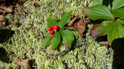
The path to Skylight was short, straightforward, and blazed. I kept an eye out for mountain ash berries, but now I noticed the red berries of the bunch berry or dwarf dogwood growing along the ground, as well as abundant patches of peat moss, mostly pale green, but sometimes red, and in one spot, a psychedelic shade of purple.

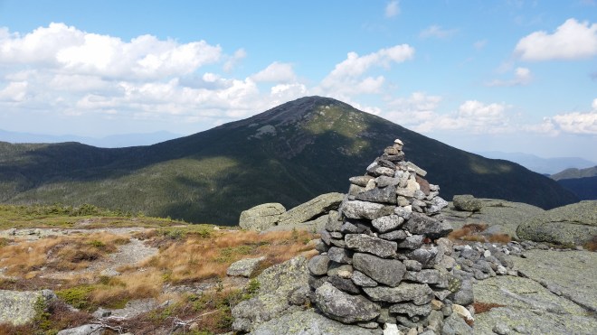
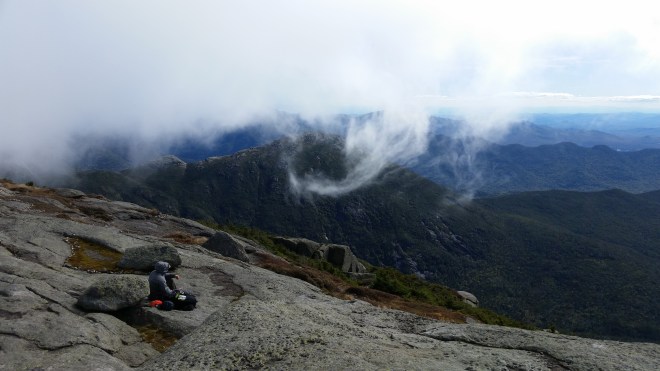
Skylight’s summit is broad and open, and this afternoon there were views in all directions: to the west, Algonquin and its neighbor Iroquois, and then Mount Colden, with Cliff and Redfield behind me and Haystack to the east, and far to the north, Whiteface, and endless other mountains walking, rolling, leaping, turning somersaults all the way out to the horizon. But Marcy dominated all else, and in the afternoon sun, its lichen-spattered summit rocks glowed green.
It was warm, sunny, and calm on the summit, so I laid back and closed my eyes for a moment. But a feeling of unease stole over me. The gentle breeze tussling the brown grass tussocks seemed wrong: this wasn’t a late summer afternoon, it was already fall, and winter in the north country comes early. Above me cloud masses churned through the sky. The geometry of the surrounding mountain ranges was extreme, and the landscape contained vast gulfs of space. Looking up made me feel dizzy.
Leaving the peak, I dropped down into the Panther Gorge and found a lean-to nestled in the woods by another rushing stream. I made a cup of tea and then ate a big dinner (not having bothered with breakfast or lunch). That night the weather did change: rain spattered for a moment, and the next morning was cool.
Now I was toiling up Haystack Mountain. Rounding the mountain’s southern shoulder, I passed a grove of unfamiliar trees with round red fruits, which might be wild crabapples, and then looking out saw Lake Tear of the Clouds off in the distance.


After climbing a thousand feet along typical steep rugged trails, stepping from boulder to boulder, I reached the exposed rock face above treeline. The path was now marked by cairns and paint, and it kept spiraling upwards. Suddenly I understood where the mountain got its name: the summit is shaped like a stack of hay.
To the west clouds were moving swiftly across Marcy obscuring the summit, and as I neared Haystack’s top, the winds began to buffet me. Stumbling across open rocks, I nearly lost my balance in the gusts, which I estimated at 40-50 mph. At one point, I wasn’t sure which way the path went — and suddenly realized how dangerous it would be if thick fog or rain obscured the markings, leaving one lost and exposed. I was supposed to climb Marcy next, but now I decided to skip it and go home.
It was a relief to regain the shelter of the woodline and look back at Haystack and Little Haystack, a secondary summit on the ridge.

Back in forest and out of the wind, however, my confidence returned. The path dropped down off the ridge and then took me up Marcy’s shoulder — and realizing this was the last uphill of the day, I put some vigor into my step and dug in with the poles. I began to reconsider the decision to skip Marcy — it wasn’t far away, and the trail was straightforward, as I recalled from a hike there a year ago with my friend Dave. When I reached the junction, there were a couple of hikers en route to the top, and that clinched it: up I went. I dropped my heavy back and surveyed the half-mile route to the top.

Without the extra weight, I scampered upwards, the anorthosite rock faces offering great traction for bare feet, and managed to pass a handful of shod hikers, which is always fun. The winds were strong, but not as bad as on Haystack, and the sun shone through swirling mists. Well over a dozen people were hanging out on top, eating, resting, taking in the views. Marcy was known to Native Americans as Tawahus or the cloud-splitter, and as I watched, clouds rushed against the summit and split into two streams and suddenly a tendril of mist rolled over in a corskcrew.

The return was seven miles. I took it nice and slow, as my feet were at this point feeling a little tender. As I neared the end of the trail, a flash of green caught my eye, the caterpillar form of the laurel sphinx moth (Sphinx kalmiae).

Back at the parking area, the thermometer read 55 F. The surreal summer-like heat was gone, and fall was back in place. As a barefoot hiker, I won’t return to the Adirondacks until next June. On the long drive home, the Catskills seemed suddenly a little tame.
Note: total distance covered was 27 miles. I carried Vibram Five Fingers and wore them on the descents from Redfield and Gray, so total barefoot distance covered was 25 miles.
Running the Long Path is available on Amazon


[…] only 43% complete — there were too many conflicts, like the SRT Race and and a trip to the Adirondacks — but October is coming together nicely with 74% done and plenty of time left in the […]
LikeLike
[…] (going straight through the forests off trail). I also made two trips to the Adirondacks, and while in Lake Placid, met Wynde Kate Reese, proprietress of Green Goddess Natural Foods, who […]
LikeLike