Time is short and so in lieu of writing up a narrative, here are some notes and images from a recent traverse of Graham, Balsam Lake, Hunter, East Rusk, Rusk, and SW Hunter — 27 miles that left me tired and hungry, but which contained several memorable moments, thanks to glorious February sunshine, dramatic winds, and the unavoidable adventures associated with nighttime bushwhacking.
The pleasure and value of every walk or journey we take may be doubled to us by carefully noting down the impression it makes upon us….It was not till after I got home that I really went to Maine, or to the Adirondacks, or to Canada. Out of the chaotic and nebulous impressions which these expeditions gave me, I evolved the real experience. There is hardly anything that does not become much more in the telling than in the thinking or in the feeling.
— John Burroughs
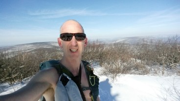
Graham
- Driving down Dry Creek Road toward the trailhead, there was a spectacular front-on view of Graham under yellow morning sun. It looks like a flat-topped pyramid (“frustrum” or “truncated pyramid” is the mathematical term), and made me think of the pre-Aztec Pyramid of the Sun in Teotihuacan, Mexico.
- Wonderful 40F and full of sunshine. Took off shirt to keep from overheating
- Feeling fresh, tried to keep to a 3 MPH pace heading uphill on a long gradual incline
- Last 800 feet a tough slog: steep and soft snow
- The summit is surrounded by thickets of stunted cherry and yellow birch (the easiest way to tell the difference is the cherry has somewhat darker bark and the buds grow at the end of twigs, rather than on the sides)
- From the top, views to the east and also back toward Balsam Lake, where the windows on the firetower glinted in the sun. Can also see the broad valley with Route 28 curving off to the east. Next time need to see if I can pick out Eagle and Balsam and Double Top.


Balsam Lake
- Less than 1 mile from the Graham trail junction
- Ski tracks on the trail. Someone told me that “alpine touring” is the best kind of ski to use on Catskill trails
- Tried to climb the firetower at the summit, but suddenly the wind picked up, as if trying to discourage me. I took a few steps up, as always fearful of heights, and now the wind was blowing very strongly. Clutching the railing, I looked desperately about, trying to identify some of the surrounding mountains (I’d even brought bincoculars), but after a few glimpses I retreated to the base
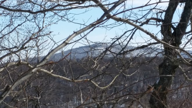
- Ran much of the way down in the soft snow, pausing to capture a view of Graham from Balsam Lake’s shoulder
Hunter
- Arrived at Devil’s Tombstone campground around 3 PM and signed in at the register. Down in the notch it was still but up above the winds were roaring.
- Hoofed up the steep ascent (Devil’s Path), still in the sun. Around 3,000 feet the trail levels off and the terrain opens up. It’s very pretty here, noticed a lot of paper birch mixed in with fir and spruce (which reminded me of the Adirondacks) and tore off some bark and stuffed in pockets to help start a fire later on.
- Took the yellow trail 1.6 miles tunneling through fir in the shadows. With the warm weather, water was dripping off all the trees which were rapidly shedding themselves of snow. Tried to pick out the difference between fir and spruce, but just ended up confusing myself. Note to self: fir cones point up, spruce hang down, and also fir tends to have sap blisters on bark
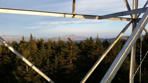
- Arrived at the firetower a little after 4 pm. Winds gusting and tearing around the clearing, roaring up overhead, whipping and tossing the trees around (but they don’t seem to mind).
- Climbed a few feet up the fire tower and got nice views of the Blackheads and Kaaterskill High Peak/Rountop in the late afternoon sun, before retreating

East Rusk
- From the firetower, headed downhill along the Spruceton Trail. Beautiful forest of fir/spruce — not thickets or remnants but tall stout individuals reaching 60-70 feet high. Passed a couple of trees covered in usnea lichen and wished I’d stopped to take a picture. Late afternoon light catches the tops of the trees as they dance in the wind.
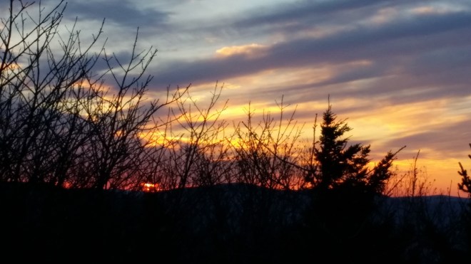
- Beautiful sunset, full or oranges, golds, cerise, at first a glow above West Kill mountain, then spreading out overhead. Stopped to admire another view of the Blackhead Range in the sunset alpenglow
- East Rusk and Rusk looming ahead in the twilight, looking very big and steep — feel a little anxious with the wind, 15 miles already under my belt, getting dark and an unknown bushwhack in front of me
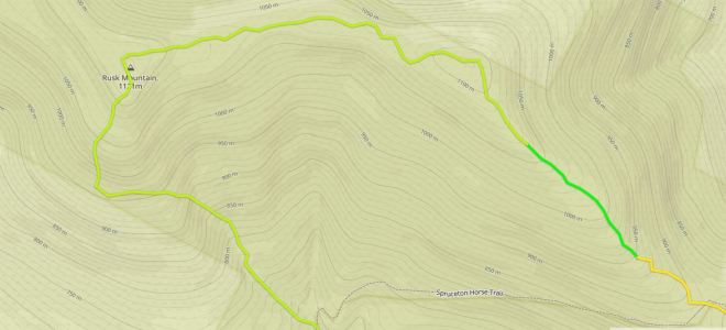
- At the saddle (where Spruceton Trail takes a jog-leg and there’s a bar to tie up horses), head off trail up the slope, following some ski tracks. The slope is mild and the forest relatively open. It’s getting dark now, I leave the ski tracks behind
- Follow the rule of up and keep moving toward the summit along a long, gradual ridge. Venus is hanging in the northwest, incredibly bright drop of molten silver. Glance up and now all the stars are out. To the north, lights sparkling down below in the valley, village of Hunter
- The winds were blowing from the west, and in the saddle it had been quiet, but as I got closer to the summit, the winds picked up in intensity again. Since these are westward winds, you are safe from them on the eastern slopes it would seem
- Soon in fir/spruce environment, a couple of ledges and some thickets, but generally pretty open and easy to move through. Lots of tall, healthy looking “tree people” (as John Muir might say). Wander around on top and across the summit

Rusk
- From East Rusk, the ridgeline continues west towards Rusk, and it’s almost completely flat (losing little more than 100 feet from summit to the saddle). At first I followed a compass heading, but sensed that I was drifting south. Once I got back on the ridge, I could see Venus to my left, and the lights in Hunter village to my right, which meant that I was right on the crest of the ridge (where I wanted to be). With these two navigational aids, the star on my left and the town lights on my right, I followed the ridgeline west-northwest and then as it turned west-southwest and climbed again and arrived at Rusk without issue.
- There were plenty of tracks at Rusk, but they seemed to be heading down the steepest part of the valley and I wanted to hit the ridgeline that Todd, Alan, and I had found back in January which is less severe. I pointed myself south and made my way down through untracked snow, and it was steep and a little disconcerting. I was worried about rock ledges, but mercifully didn’t encounter any. A few lights gleamed down in the valley and I tried to steer by these, making guesses about where in the valley they were located.
- After a little bit, I checked the map on my phone and saw I was heading a little too far to the west-southwest and about to cross into private property. I measured a new azimuth on the map and to make sure I didn’t stray into the private property, I made a point to steer a little extra to the left.
- Checking the map a few minutes later I found that now I had way overcompensated to the east and was heading right for the steepest section of the draw, the area I’d meant to avoid all along. But it was too late to get back onto the ridge: before I knew it, I was caught in a ravine. During the summer, this would have been a disaster — stumbling downhill on broken, slippery rocks and crossing fallen trees without getting feet wet — but now the stream was covered in 2-3 feet of snow, so the going wasn’t so bad. But this is a good lesson learned: be very precise following compass headings when going downhill (especially at night) because small mistakes send you in the wrong direction and it’s going to be time-consuming to recover. Following a compass heading doesn’t mean running downhill with a compass in hand and a rough sense of the right direction — need to measure and follow the azimuth precisely — made similar mistakes coming down from North Dome and Sherrill last week.
Southwest Hunter
- The hike back to the Devil’s Path and then up to the Devil’s Acre lean-to took a long time. I was very hungry and tired. Took off snowshoes to give my feet a break and put on spikes, but snow was a little on the soft side and sometimes sunk in an inch or two.
- Unfortunately the Devil’s Acre lean-to was occupied. Which meant no dinner. Got a drink of water from the spring and decided to skip dinner, as fire would not be allowed outside of the lean-to and no wood available anyhow with 2 feet of snow covering the ground. Set up my tent in a meadow a few yards away, pacing 150 steps from the trail. Went to bed around midnight. Despite mild conditions, hard to tell whether I woke up every hour and shivered, or whether I just lay there the whole night shivering. Gusts of wind rushed around the summit, from time to time descending into my clearing and tussling the tent flaps. By morning the winds had quieted.
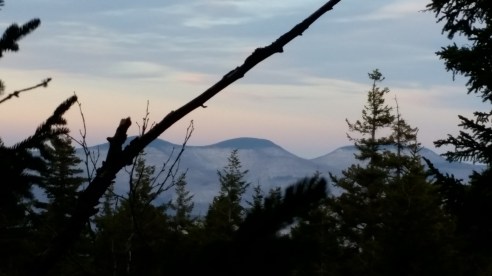
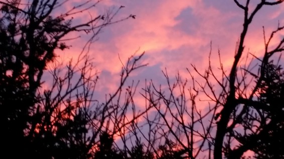
- Got moving at 6:20 AM and hiked over to Southwest Hunter and back. Above me clouds turned cerise and rose with undersides still blue. View of Rusk in the morning alpenglow. Heard nuthatches and paused for a moment. Two white-breasted nuthatches fluttered by and landed on birch trees just a few feet above my head, then flew off with strong rapid beating of the wings almost like a miniature grouse. They seem to like the paper birch trees.
- Looking down into the notch that 214 runs through, Plateau Mountain across the road, in the distance blue skies and golden sun-clouds.
- Struggled with the descent back into Devil’s Tombstone as trail is slanted along the top and this tweaked my right ankle.
- At 2800 feet passed through what seemed to be a mix of hemlocks and fir.
- Final 800 foot descent into the parking area was very steep and sloppy (wet, slippery snow) — very hard on right ankle.

You actually make it appear really easy with your presentation but I in finding this topic to be actually something which I feel I’d never understand. It kind of feels too complex and extremely broad for me. I am looking forward on your next publish, I’ll try to get the cling of it!
LikeLike