With a Nor’easter blowing in, it was touch and go, but I managed just barely to complete the Grid for October, and along the way was the chance to explore some off-trail ridges. These are magical places that make you feel like you’re walking across a suspension bridge, or the battlements of a castle. They give you a break from the claustrophobic tangles that blanket much of the Catskills, reveal the wild and soaring topography of the mountains, let you revel in space and light.
Sugarloaf
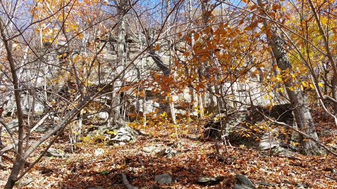
It’s a warm clear day in late October. They trail from the parking spot on Mink Hollow Road is full of rocks, and this makes for a slow start to the morning. It takes a quarter mile to pass two houses and cross a stream, before leaving the trail behind and trudging uphill, heading straight into the morning sun. Unstable rocks, wet patches, broken branches, there’s plenty of aggravation, but eventually a series of sandstone ledges reveals the ridge crest up ahead, and I scramble — a little unsteadily — upwards.
Now the walking is easier, and a thick soft cover of fallen leaves is much appreciated. A grove of hemlocks welcomes us onto a small knoll, and past this point the ridge begins to narrow until it’s only 15 yards or so wide; it’s like walking on an upside-down “U.” The forest has lost much of its foliage, the sun beams in, everything is bright and crisp, the sky is everywhere about us. Glimpses of Sugar Loaf’s parapets — the huge mountain wall connecting it to its neighbors, Plateau and Twin, looms two or three miles to the north — the Ashokan reservoir gleams ten miles to the south.

We’re following the ridge as it spirals upwards toward the summit, when a row of cliffs rises through the trees up ahead and blocks the way. Odie’s so surefooted, a pair of thru-hikers gave him the trail name, “Mountain Goat” — but nonetheless he can’t climb sheer rock, nor can I for that matter, and I can’t hoist him up with a rope even if I’d brought one. We creep around to the right and find a pile of broken slabs, steeply slanted but seemingly navigable, and a moment later Odie is up and away, while I shout “good boy!” and grope along after.
Around 3,000 feet, we encounter fir trees, the first we’ve seen, marking the boundary of the boreal zone. The ridge narrows further until it’s a rocky spine only a few yards wide, truly the edge of a knife. Bigger trees forsake these rocks, but the fir trees stick their toes into the cracks and seem quite happy to be here, indeed they spread out their limbs and clasp arms, tangling up the passage — I’m stuck between two trees with stout branches I can’t bend and have to lift my feet up and climb through, it’s slow and awkward. Odie finds an easier route a few feet below, down along the base of the rocky crest, guarded by more easy-going beech trees, and he slinks through. He should be named “pathfinder.”
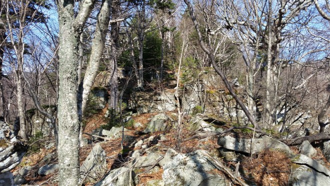
The ridge broadens out on the final 500-foot ascent to Sugarloaf’s summit. Someone who’d been here before had warned me it was steep and treacherous, and now I worry can Odie make it up (it seems I always worry about something when moving off-trail). I take an extra close look at the map, figure contingency routes back to the trail if we get stuck, and decide to veer left where the slope looks easier. But I needn’t have worried, the final ascent isn’t bad at all but for some blackberry patches, canes still bristling with a few thorns, but well past their prime and not hard to move through as long as you step carefully. If Sugarloaf was going to put up a fight, this is too little too late, and actually the mountain doesn’t seem to care about us small creatures crawling on its back. Soon we’re at the summit vantage point, which is all hemmed in by fir, offering a tiny view of the reservoir if you peer between the branches, while meanwhile clouds have begun to spread, and the light has become a little dimmer, and the air, cooler.
The descent from the summit is great fun, in fact we pass three hikers (passing downhill is a rarity when barefoot), and the sun comes back out illuminating the hulking mass of Plateau across the gap. But the 2.5-mile trail back down to Mink Hollow Road is full of big rocks hidden under leaves, a great way to twist an ankle no matter what you’re wearing, and it’s back to a slow pace and much aggravation.

Halcott
I cancel a hike with my friend Dave because of the Nor-easter, but at breakfast can’t sit still. The latest computer projections suggests the worst of the storm won’t arrive until the afternoon, so there’s a window for a short climb, if we’re quick.
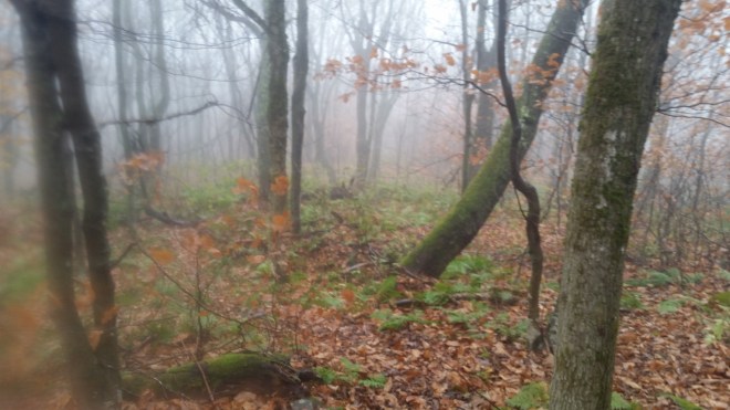
The base of Halcott is quiet, shadowy, the rain is light but steady, the ground is soft and covered in a thick layer of wet leaves, the forest is relatively open, and a broad slope stretches upwards and out of sight.
I point us straight for the summit, eager to take the shortest and quickest route, although this entails walking uphill at a slant. Sometimes I zig-zag up the slope to avoid rocks or fallen trees, and this confuses Odie, who returns to my side. But once he understands the general direction, he ranges ahead and I notice that he generally finds a pretty efficient route.
The slant is awkward, all I can think about is how I want to be on top of the ridge where it’s flat. We find ourselves in a large field of blackberry canes, most of which have turned red and wilted, but there are a few canes that are still green, robust, arching overhead, and bristling with thorns. I turn uphill to get out of this stuff, and now the ridge crest is just overhead, dim sky visible above and behind. I give up on the slant and head straight up.
The ridgetop is beautiful. Wide and flat and easy walking, with a gentle uphill slope naturally drawing us along toward the summit. The forest is hushed and dim and draped in mist, but there’s gray light on either side where the slope drops off into sky.
On the way down, there’s once again the choice between the direct (slanted) route, and the somewhat longer version that follows the ridge. Eager to escape before the storm arrives, I opt for the slant, but the blackberry canes throw us off — we have to back up a few steps to get out of them — and here we are back on the ridge. I choose a different azimuth, a vector from ridgetop straight to car, and as we descend the ridge rises above us and vanishes back into the clouds. After a little while we’re on the edge of a spur, peering down into a ravine with a stream running along the bottom. Every obstacle shunts us a few feet further downhill, and slowly but surely we’re sucked into this trap, and now we have new problems to solve: fallen trees, slippery moss-covered rocks in the stream bed, steep dirt banks on either side — and this is extremely frustrating since we’re almost back at the car! But eventually the terrain unfolds, the last few steps are easy walking once again, Odie scouts ahead for the best route down, and we’re back in the car and safe from the storm.
Kaaterskill High Peak
This isn’t a ridge, rather it’s a path that snakes along the mountain’s shoulder on a washed-out snowmobile trail that’s full of water in the best of times. I decide to get it done at night before driving home to the city, and right after the heavy rains have blown through — not ideal timing, but Kaaterskill is the last remaining peak on the October grid, so it’s now or wait for October 2018. Tonight there’s ankle-deep standing water on most of the trail, in a few places shin-deep, and the temperature’s falling into the 40s. There’s always something to worry about, and wading through this barefoot and at night makes me feel a little uneasy. But I’m dressed warm, and for all the water, there are plenty of flat stones, smooth dirt, and deep leaf litter, so I move relatively quickly, although every step requires concentration.
Odie the Pathfinder does a great job following the snowmobile trail and then the unmaintained path which scrambles up to the summit through a series of steep ledges. In many places, water is rushing down this path and cascading off the rocks. When we arrive in the small clearing at the top, the weather has blown through, and the stars are out. It must be in the 30s up here, our breath is steaming.
There’s a tricky spot on the return, where the route crosses a former ski slope and reenters the woods via an abandoned and heavily washed-out forest road. Last time here, it took me a few minutes to check the GPS and find the spot. Tonight Odie leads me straight there, without the slightest hesitation.


Running the Long Path is available on Amazon

