My son Philip was in town for a couple of weeks before resuming college, and since he’s an Army ROTC cadet and expected to be able to navigate with map and compass, I offered to take him out to the Catskills for some practice.
Our goal would be to start from a parking spot in Peck Hollow, a place I’d never been to before, and then undertake an 8.5-mile bushwhack loop to the summits of North Dome and Sherrill and back, with Philip leading the way, me keeping an eye on the GPS just in case, and Odie along to supervise the both of us.
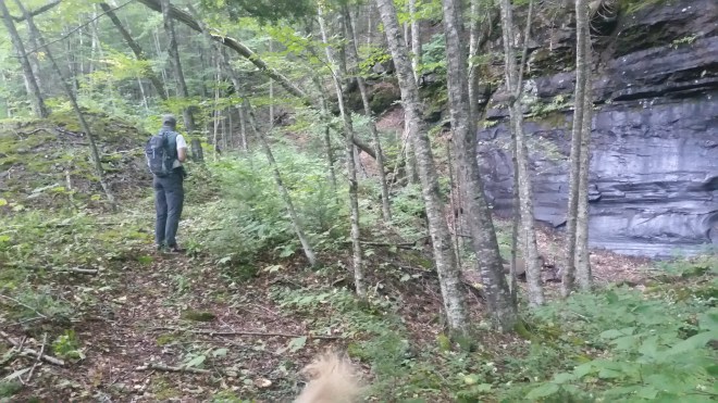
We were up at 5:00 AM, in the car by 6:00 AM, and at Peck Hollow a little before 7:30 AM, finding a parking spot marked “Forest Preserve Access” nestled beneath a large sandstone slab about 1/4 mile off from where it was indicated on the map.
Our first objective was to reach a saddle on the ridge about 1,000 feet above. I gave Philip the compass heading, which I’d computed on my cellphone map app, and he pulled out his compass — but then gave me a questioning look. It turned out I’d given him the wrong azimuth, and once this was corrected, he took off. There was an old forest road that was conveniently pointed in precisely the right direction, and this gave us easy passage about half-way up the mountain before it veered off the wrong way. At this point, compass in hand, Philip headed into the forest, with me lagging behind a little bit to fix a sock that kept falling down, while Odie ranged back and forth between the two of us to make sure our little group stayed together.
Once up on top of the ridge, Philip pointed to the saddle. Nice job!
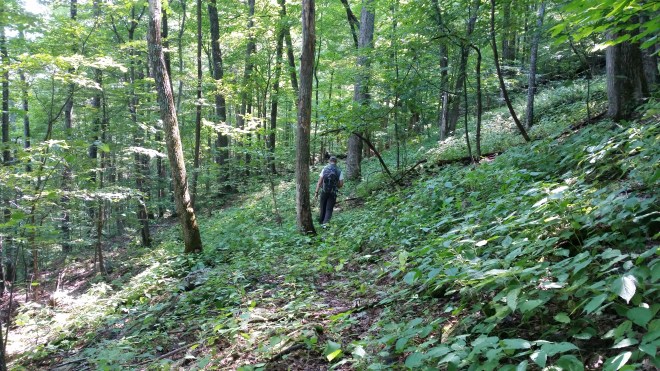
From here we had a long stroll to the summit. The forest floor was relatively open, and the ridge narrowed in places, making it easy to follow (it will offer beautiful views in a few weeks once the leaves are down). This area must have been cleared once upon a time, perhaps for pasture, because there were many oak and hornbeam trees, which I noticed from the abundant acorns and seeds strewn across the forest floor. The hornbeams look like birch trees at first glance, with similar leaves, but the bark peels off in stringy vertical strips.

After a little bit, I asked Philip to point to our current location on the map. He’d been keeping his pace count to estimate the distance traveled and based on this information pointed to a spot about half-way to the summit which I confirmed was correct using the cellphone GPS. So far, so good.
Above 3,000 feet, the oaks and hornbeam disappeared, and then as we drew nearer to the summit, the terrain got steeper and the vegetation more tangled, with hobblebush and club moss becoming prevalent on the forest floor. We passed through a clearing full of hay-scented ferns surrounded by fir trees (which struck me as an unusual combination), and then we were moving through the boreal zone. A little while later we came upon the trail about 100 yards west of the summit, which was not bad after traveling three miles through the forest.
At this time of year one expects to find a pretty well beaten-down social trail between neighboring summits, and we weren’t disappointed (while these trails take away much of the challenge of bushwhacking, we were happy to have easier walking for a bit). Philip led the way, checking the compass to make sure this path was taking us in the right direction. After descending a ledge where Odie needed a hand, and then stepping through a muddy spot, we found ourselves a little while later crossing the saddle between North Dome and Sherrill, and then heading back up.

From the saddle, there is a 400-foot climb to the summit of Sherrill, and a few minutes later we were signing in at the canister.
Now it was time to head down a long pathless ridge back to Peck Hollow, and I cautioned Philip that moving downhill is typically more difficult because on the one hand, if you don’t follow the compass exactly, you could drift off course, while on the other, if you stuck too closely to the azimuth, you might find yourself walking across steeply slanted terrain, which can be very uncomfortable.
But as we headed away from the canister, we were surprised to find another social trail headed in exactly the right direction, so we enjoyed a quick start to the return journey.
Then the social trail petered out. Philip took us downhill through the forest into a patch of stinging nettles. Some plants had sent out long purple and yellow “racemes” which contain small male flowers that release pollen into the wind, while other plants had white female flowers in bloom and green fruits. Judging from the extent of nettle growth, these reproductive mechanisms have proved very effective. Stinging nettles are so-called, of course, because the stems and leaves bristle with short hairs full of toxins, and these managed to poke through our trousers and give us some stings, and where that sock had fallen down, my ankle was vulnerable as well. But the stings didn’t last long.


Suddenly in front of us there was a clearing, full of waist-high nettles mixed in with an assortment of wildflowers, including red bee balm and orange jewel-weed. The light and colors made it look cheery, but I suggested to Philip it might be more comfortable to veer around than plunge straight through. As we were doing so, we saw there was a school bus sitting in the middle of the clearing, behind a strangely-bent birch tree which might be a Native American “marker tree” (it was their practice in days gone by to tie down saplings so that they would grow into distinctive shapes).


We could hardly have been more surprised to encounter a bus at the top of the mountain than if we’d chanced upon the Cat-Bus from My Neighbor Totoro. Yet sitting at rest in this sunny clearing full of flowers, the bus looked peaceful, as if this were home. The structure was level, and the seats had been removed and a bunk bed installed, so perhaps it created as a shelter.
Philip and I conferred. It didn’t seem likely that a school bus had been driven all the way up a mountain….but it probably wasn’t carried in by a helicopter: therefore, it must have been towed up here. Which meant, there ought to be some kind of forest road. And sure enough, we found an old road in surprisingly good shape, neither washed out nor grown through with saplings. The three of us scampered down this road, delighted to be making good time, and remarkably it took us straight down the crest of the ridge, in exactly the direction we wanted to travel. There was only one explanation: this was a gift to us from the Catskill spirits, possibly as a reward for Philip’s accurate compass-work, or maybe just an act of capricious good will.
The road took us about half way down the mountain to a saddle on the ridge, and then it turned north, whereas we needed to go south, but now there was another gift from the Catskill spirits: ripe blackberries! In the last few weeks I’d observed that this year’s blackberry crop was disappointing (maybe the summer was too cool), but perhaps you just need to know where to look.
From here it was back to walking through the forest, and now we experienced a mix of open forest with oaks and hornbeams once again, as well as more typical Catskill tangles with beech suckers and birch saplings. We passed a beautiful open ridge.

And then it was back into the nettle zone, with small oceans of the stinging plants smothering the ground, but mercifully in one spot a narrow trail materialized to provide us safe passage and then vanished a few yards later among a pile of rocks.
Philip led us straight down the mountain, at one point drifting a little left, then correcting, while I kept one eye on the GPS, and another eye on an assortment of interesting fungi, including gleaming white coral fungus and puff-ball mushrooms that discharge smoky spore clouds when touched.


We dropped down the ridge and a paralleled a steep slope, then the valley widened out. According to the map, we were crossing over the Shandaken Tunnel, which carries water from the Schoharie Reservoir and discharges it a few miles away into the Esopus Creek, where it flows into the Ashokan Reservoir and is then carried via aqueduct to New York City. I wondered if we’d see any signs of the tunnel, although if it was buried deep under the mountains that seemed unlikely, but a few steps later we stumbled across ventilation ducts. It would be an interesting project to hike the tunnel’s entire route and see what other clues to its presence are out there.

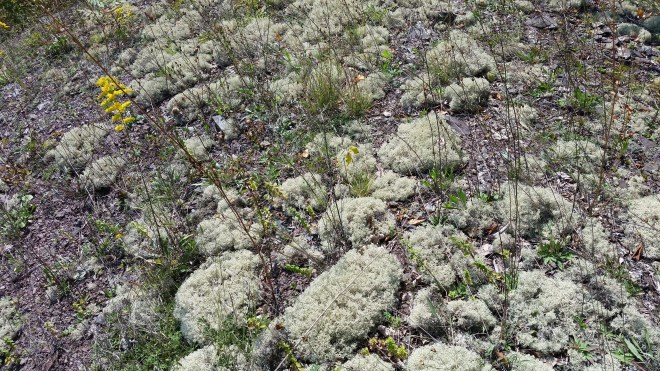
We descended a slope of loose rocks, which might have been piled up over the tunnel or might have been natural (it was hard to tell), and there was a final discovery: extensive clumps of prickly gray and green reindeer lichen. Lichens are slow-growing creatures, so when you find such extensive growth, you know you’re moving through an area that doesn’t see much foot traffic.
We surfaced on the road a hundred yards south of the car. Mission accomplished: Philip had gotten some extra land navigation practice, while I’d scratched off two more peaks for the grid. And he, I, and Odie all enjoyed a beautiful day in the mountains.

Running the Long Path is available on Amazon


[…] like an arrow to Westkill’s neighbor North Dome. It’s a route I remember from a hike with my son Philip, and from here you can see how the oaks peter out at 3,000 feet, above which point the spur is […]
LikeLike