East coast naturalist John Burroughs once wrote, “To learn something new, take the path you took yesterday.” With this thought in mind, I returned recently to Peekamoose Mountain, one of my favorites in the Catskills, and a peak whose trail I’ve taken many times. On this occasion, the plan was to survey the bushwhack from Peekamoose to Lone Mountain, so that I can improve my time when I next attempt the Catskill 35, as well as experience the sights and sounds of a beautiful late summer day.
Mindful of the crowds thronging the nearby Peekamoose Blue Hole, I woke up at the crack of dawn and arrived at the trail head a little after 7:00 AM. However, the early start proved unnecessary, as the parking area was empty.
Peekamoose was the first Catskill mountain I’d climbed barefoot, and today I decided to repeat that mode and then switch to Vibram Five Fingers for the bushwhack and descent. I’d forgotten the gravelly nature of the Peekamoose trail, however, which like its neighbor Slide Mountain contains plenty of conglomerate sandstone that’s eroded into chunks of rock and occasionally gray sand. The climb was long, slow, and a little bit more painful than I’d expected.
As I started up the trail, the woods rang with a long series of chirps, which I imagined were produced by chipmunks unhappy to find a stranger in their territory. But it gradually became apparent that the chirps were issuing from somewhere high up in the forest canopy, and I couldn’t remember ever seeing a chipmunk in a tree. Perhaps this was a bird?
And here was another mystery: the trail was strewn with small dark berries, which I’d noticed the last time on Peekamoose, and which I’d attributed to the ubiquitous hobble-bush (Viburnum lantanoides), whose berries mature this time of year. But when I surveyed the surroundings, there was no hobble-bush in sight, none in fact anywhere in the vicinity. I looked to the left and right and then craned my neck and peered upwards, but there was no visible source for the berries. Could chipmunks have transported them from distant locations? But why would they do that?
Then I reflected on the black cherry trees (Prunus serotina) soaring so high above me, the leaves weren’t even visible. It occurred to me, if there were berries (or cherries) growing on the trees, they’d be out of sight, until the ripe ones fell to the ground. When I reached Reconnoiter Rock, a glacial erratic perched on a rock ledge about half-way to the summit, I found a young black cherry tree nearby, and I could see small dark fruits growing among its leaves. This mystery was solved.

I encountered another hiker at Reconnoiter Rock who like me was planning to bushwhack to Lone. He thought there was a “social” or unofficial trail to Lone that started at the low point between Peekamoose and nearby Table Mountain. Following a social trail is much faster than fighting through thick vegetation, so I thanked him for this intelligence, and continued along.
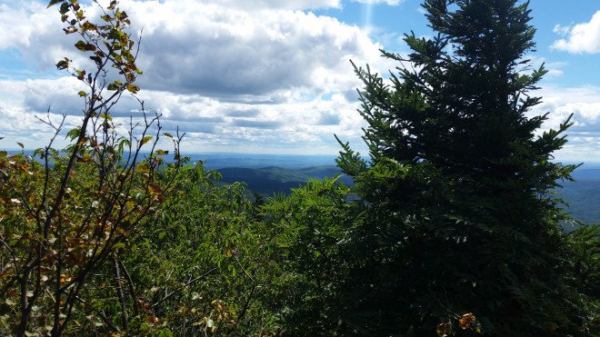
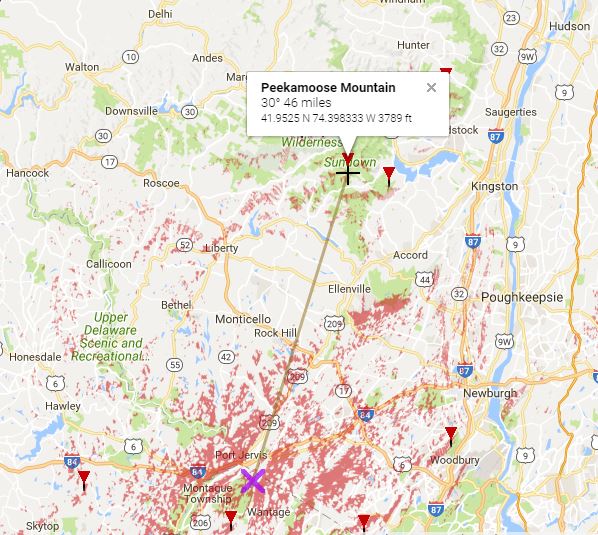
Near the summit of Peekamoose was a vantage point with extensive southern vistas. As I peered into the distance, I could just barely make out, or so I thought, the Monument Tower at High Point State Park in New Jersey. This tower holds a lot of significance, as it marks the junction of the Shawangunk Ridge Trail with the Appalachian Trail, and is also the starting point for a 70-mile race I organize each September. But it was hard to be sure, because the distant tower appeared no thicker than a needle. To resolve the issue, I pulled compass from pocket and shot a 210 degree magnetic azimuth, which I’d plot on the map when I got back home.
Now it was time for the bushwhack to Lone. I put on the Vibram Five Fingers, giving my feet a welcome break from the rocky trail, and followed the path downhill until I reached the low point between Peekamoose and Table, where I scanned the wood line, searching for the social trail the hiker’d mentioned. But there was no sign of a path. I continued uphill toward Table and then stepped into a dense thicket of young fir trees higher up on the ridge.
In previous attempts on Lone, when moving through this area I’d typically dropped down the side of the ridge too quickly and found myself getting sucked down a steep slope which leads eventually to the Neversink River, well over a thousand feet below. To correct course required cutting across the face of the ridge, but even so, I’d always come out downhill from the saddle between Table and Lone, and then have to fight uphill through thick vegetation to get back on course.
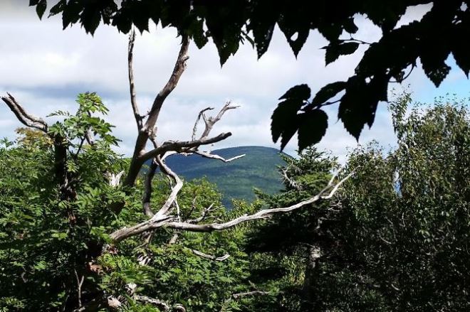
Today, I took my time, groping through the fir trees in search of the topmost crest of the ridge, which ought to offer the most direct route to that elusive saddle. I pushed my way through intertwined branches until a glimmer of light shone through the forest on my left and my right, a clear sign that the slope was dropping away on both sides. And suddenly here was the social trail, right at my feet: an unmistakable foot path, not marked with blazes, but easy to see from the trodden dirt. The path took me straight down toward the saddle, and at one point from a small clearing in the tangled forest, Lone raised its head and peered at me through a gap in the trees.
The social trail disappeared momentarily in the saddle, but since the ridge leading up to Lone is fairly narrow, I found it again within a few steps. From here the path led me straight up to Lone’s summit. At one point, it scrambled up a narrow cleft in a rock wall, but otherwise it was almost as easy to follow as an official trail which is blazed and maintained and it was certainly much faster than stumbling along on steep terrain and through thick vegetation while trying to follow a compass bearing. The trip was a success: now I knew the fastest way to reach Lone.
After gaining the summit, I turned around and followed the social trail back the way I’d come — but something felt wrong. Consulting GPS, I discovered I’d unwittingly turned onto a different social trail, one which was heading north and downward toward the Neversink River. This just goes to show how easy it is to make mistakes while bushwhacking! I retraced my steps, found the right trail, and headed for home.
The Vibram Five Fingers provided adequate protection from gravel, but no real cushion against the rocks. By the time I was half way down, my feet were tired. I was feeling relieved to be nearing the end of the hike, when once again the forest canopy rang out with a steady series of chirps. I looked around but couldn’t spot the source.
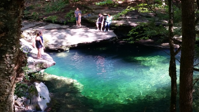
When I arrived back at the car, my feet were ready to for a break, but first, I wanted to check out the Peekamoose Blue Hole, which lies just up the road. Last time I was here, the cars filled the parking area two and three deep and spilled out along the shoulder of the road, while people strolled around carrying coolers and radios, and two harried rangers tried ineffectively to impose some order. These crowds had been attracted by social media proclaiming the Peekamoose Blue Hole one of America’s top swimming holes. Since then, the DEC has imposed tougher rules and cracked down on offenders. And the word must have gotten out. Even though it was the Friday before a holiday weekend, this time the roads were quiet, and only a handful of people were hanging out. I had never before set eyes on the fabled swimming hole, and now I discovered that it is indeed a gorgeous spot. If you go there, just be aware that glass containers and radios are not allowed, parking is restricted, and if you carry it in, you should carry it out — please don’t litter.
When I reached home, I verified that the 210 azimuth I had shot from Peekamoose does indeed point to the Monument Tower at High Point, some 46 miles away. It’s a cool feeling to be able to look out across the horizon and spot distant sights.
After extensive research on the internet, I think I identified the source of the chirps I’d heard. These were a a squirrel’s alarm call, and specifically the “kuk” vocalization. Scientists have determined that this sound is meant both to alert other squirrels to potential predators in the area as well as let the predator know that it’s been spotted. Cats have been observed to give up on the chase once they hear the “kuk” warning.
There’s evidently a lot to learn from a hike up Peekamoose or any of the Catskill’s mountains, and I can’t wait to go back.

[…] Rock. It lies a little short of 3,000 feet in elevation, up about 1,800 feet from the start. On September 2, 2016, I spent a moment exploring Reconnoiter Rock and discovered that many of the saplings growing in […]
LikeLike