For a long hike in the Adirondacks, a big breakfast and real espresso would provide a good start to the day, but they would also necessitate a long drive out of the way, so a good start was also a late start, with the trailhead not reached until a little before 9 AM….and it wasn’t until 10 PM that I finally straggled out, having covered 15 miles, climbed three mountains, and waded through several thousand gallons of water and mud. This may well have been the most taxing Adirondacks hike I’ve ever undertaken, but it bagged three more peaks, leaving me at 29 out of the 46 High Peaks complete without shoes.
- The hike started out on a gravel road full of large chunks of black rock, which made walking barefoot a little awkward and lent an air of uncertainty to this operation, which was already off to a late start. However, after the first quarter mile, the gravel faded, and I was able to sustain a decent pace by wiggling back and forth between a grassy strip in the center of the road and soft earth on the shoulders.
- After a mile and a half, the gravel road passed a trail on the right, and just in case you missed it, a big sign nailed to a bridge “GO BACK – NO TRAIL ACCESS PAST THIS POINT.” So I went back.
- The trail started out in very nice shape, having recently been renovated: smooth, level, all soft springy dirt with a little sand mixed in, and perfectly dry, thanks to artful rock-lined drainage ditches. What a pleasure! And how nice to see that in the Adirondacks, which are home to some of the worst trails I’ve seen anywhere in the world, there’s also a program in place to maintain and improve. Of course, this beautiful trail wouldn’t likely last, but the next 1/2 mile was very pleasant.
- After crossing a brand new wooden bridge, the trail headed uphill a little bit above the Santanoni Brook, which was flowing vigorously. And that was the end of the renovation: from this point on there was no drainage on the trail, in fact it was running with water along its entire length. I splashed along, hopped from rock to rock, and sometimes climbed up on earthen banks alongside the trail. Some wooden planks (bog walks) were laid out in one area, which was nice for the 30 or 40 feet they lasted. After that, the trail was strewn with logs. Possibly it was once upon a time a “corduroy road” (lined with logs laid perpendicular to the direction of travel), but most of the logs had deteriorated, sunk into the mud, or rotted away completely.
- Many of the Adirondacks trails are “unmaintained,” meaning in theory that they’re not blazed, signed, or maintained, so it was a surprise to see an official sign telling me exactly where to go:

- Once past a small bog, the trail wound its way up toward Panther Mountain, at first creeping beneath a set of dripping cliffs, then squeezing among trees and up and over boulders, and then finally following a rushing brook uphill to a saddle on the ridge.
- “Times Square” is a four-way junction in a saddle right below Panther’s peak. One direction takes you to the summit of Panther, and here the trail disappeared into a thick pit of soupy black mud whereupon I sunk to my knees and then lost my balance, nearly falling in. This taught me a lesson: don’t laugh at the felled trees thrown into these mud pits, no matter how thin and insubstantial, but rather make sure to walk across them carefully, like walking across a balance beam, because even if they sink an inch or so beneath the surface or twist around, they might save you from plunging in to your ankles, calves, or knees.

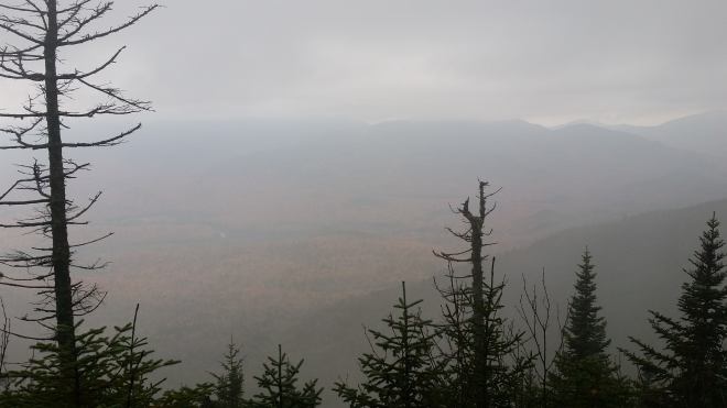
- No views today. A grim day with overcast skies and thick fog blowing through the forest. Everything dark, a feeling of perpetual late afternoon. It’s that time of year when summer is fading away and winter nearing. Forests quiet and dim, conveying a sense of nostalgia and regret for the passage of time, inspiring a little anxiety to keep moving before the light is gone.
- Back to Times Square, and now for the long slog over to Couchsachraga, an inconspicuous peak that no-one seeks out unless they’re working on the 46. It’s not even 4,000 feet high but was included in the original list due to a surveyor’s error, and the current list respects the original list, mistakes and all.
- At the saddle beneath Couchsachraga, another small bog with thin trees lying in the mud to walk across on:

- No point in dwelling at Couchsachraga, so back across the saddle and bog, where glancing up a view of mists blowing across the upper slopes, and then back up to Times Square. And now off to Santanoni along a trail that’s muddy but not too steep. I study boot and shoe prints in the mud, trying to sort out the different tread marks, but in the fading light they all look the same (perhaps all that’s showing is the marks of the last person through whose steps have obscured the passage of everyone before).

- Close to the top, a dim view mist-shrouded ridges across the way and a hint of warmth down in the valley, which is the brilliant peak fall foliage, and especially the maples, if only you could see clearly.
- As I’m descending from Santanoni, I hear voices. I give a yodel, and through the mists a response. It’s a couple I’ve encountered twice now, who are on the same circuit as me and about 1/4 mile behind. The first time I met them, they were surprised to encounter someone hiking barefoot, so I told them that my shoes got sucked off my feet in the mud — which got a laugh.
- The descent from Santanoni is steep. Almost 2,000 feet down to the next trail junction. Plenty of spots where I have to lower myself down a boulder, or step on wet twisted roots, or climb over deadfall, or step carefully through mud or water not knowing how far my foot will sink and what kind of objects it will encounter. No point in rushing, indeed, rushing might well be fatal. I glance at my watch from time to time to see the altitude, eventually reach 3,900 feet, which means only another thousand feet to go. And then every so often I look again, and sometimes one or two hundred feet are gone, and sometimes only twenty or thirty — and the watch is set on a less accurate mode to preserve battery life, so sometimes the numbers bounce around randomly.
- The trail finally flattens out, which is good, but there are so many mud pits and slippery mud-slicked rocks, and slimy logs, that a decent pace isn’t possible. I start to get frustrated, come close to losing my cool, but somehow persevere until reaching the main route again.
- Just as I reach the junction, here are those two hikers again coming up from behind. Their names are Steve and Lisa. We walk out the last three miles together, and having some company makes the distance pass a little more quickly, although I have to scoot in some places to keep up with them. Steve is a very experienced Adirondack hiker and gives me some tips on his favorite brand of backpacks (Mystery Ranch) and the rechargeable headlamps (Nicor) and shares stories of winter hiking at -20 F.
- On the final walk out, we hear whistles coming from the trees. The best guess is that they are gray tree frogs, but this isn’t their trilling call, so no-one’s really sure.
- This was a long day. Yesterday 15 miles took me 10 hours, today the same distance took 13 hours — 30% longer. No dinner for me tonight, as everything’s closed. I shower and scrub my feet, but they appear to be permanently stained by all that mud, which could get me in trouble back home. Tomorrow morning a big breakfast and the long drive back.
Running the Long Path is available on Amazon (Click on the image to check it out)
