After three days in Lone Pine, California, the grand tour of Owens Valley continues, and now it’s time for Bishop. First stop: the public land visitor’s center, where I enter the lottery for an overnight permit for the Bishop Pass trail. It’s a popular trail, but there’s not much competition mid-week, and a little later that morning, after a series of instructions from the Rangers (where to park, where to camp, how to dispose of waste, how to keep bears from eating your food, and not to mention watch out for dead deer on the pass and the thunderstorm forecast for tomorrow afternoon) — I stroll out with permit, map, and rented bear canister in hand. Now it’s time to prepare for the mission: map the drive to the trailhead, study the route, buy food, pack my pack, and rig up a carrying strap for the bear canister so I can sling it over a shoulder, it being far too large to fit in my 20-liter day pack.
The next morning I’m up at 3:00 AM, determined to steal a march on the weather and secure a parking spot before the crowds….
Arriving at the trailhead around 4:30 AM, it takes a minute or two of tugging and struggling before I discover the lid on the parking area’s heavy metal bear locker opens outwards, not upwards. Puzzle solved, in goes a bag with toiletries, food, and trash, leaving no incentive for a hungry animal to mess with my rental vehicle. It’s cold — low 40s — and a bit of a shock to the system for someone who’s spent the last couple of weeks in desert conditions (including a high of 120 F in Death Valley). I pull on long underwear and a sweater and decide to keep shoes on as I wander around trying to find the right trail. After checking compass and map, I finally head out, flashlight playing across the sandy, rock-strewn path, damp from rain the day before, the forecast for showers (40% probability between noon and 7 PM) and low temperatures (upper 30s at night) weighing on my mind.
The sky begins to lighten some time around 5:30 AM, at which point I’m a mile and a half in, just reaching the northern end of Long Lake. To the west, Hurd Mountain (12,237 feet) glowing in the morning sun, its peak reflected in the lake’s still water. To the east, some pine trees and then a massive pile of scree sliding downhill.

The trail heads south through this narrow valley, passing Spearhead Lake, Saddlerock Lake, and Bishop Lake. Somewhere in the distance, the pass is located in the gap between Mt. Goode to the west and Mt. Agasiz to the east, which from here looks like a great pile of granite rubble. Soon I’m laboring up a series of switchbacks carved out of the loose talus — it’s actually quite a professional job, with rocks piled into walls and stones laid out for steps — but I’m feeling the altitude this morning: out of breath, heart racing, and getting extremely hungry.
Close to the top of the pass, a noxious smell, and then a gruesome sight, just as the Rangers in the Bishop Visitor Center warned me: dashed against rocks the carcasses of twenty or more white-tailed deer, with a handful of crows picking through the bones and hides. It looks like an entire herd was wiped out. No-one was there to see it happen, so all people can do is guess: maybe they slipped on steep ice — blown off the ledge by ferocious winds or spooked by a mountain lion? — or maybe they were caught in an avalanche. It’s a disturbing sight, because animals seem so sure-footed. Sure, individuals are constantly falling by the wayside for a variety of reasons, leaving the fittest to persevere — but for a whole herd to get wiped out indiscriminately?

Finally, the top of the pass, 11,972 feet. Looking behind me, to the north, all those lakes gleaming in the morning sun and beyond them huge mountain ramparts plunging into the Owens Valley some 6,000-10,000 feet below. It’s only a little after 8 AM, and no sign yet of weather.

Onwards. Descending the far side of the pass, continuing south toward the Dusy Basin, which is where I plan to camp. No longer out of breath, but still feeling hungry, I walk along a couple of miles, looking for a campsite. But with the weather forecast in mind, and imagining violent gales and torrential rain, I want my campsite to be sheltered from the prevailing westerly winds by rocks or trees (but not too tall lest they attract lightning). The basin is dotted with pines, but otherwise wide open, and no campsite measures up to these standards.

A couple of hikers pass by. We confer. No-one likes rain, everyone would rather be on the north side of the pass when the storm hits — psychologically, the pass is like a huge wall, and no-one wants it standing between them and safety.
What to do. I don’t want to walk any further downhill into the Dusy Basin. It’s still mid-morning and way too early to set up camp. I could turn back, but the top of the pass is not a good place to get caught by lightning. Looking to the west, fluffy white masses are rising behind the mountains. In the east, gray plumes are forming above Mt. Agasiz. I pause to eat some of my food (supposed to be for dinner) and contemplate alternatives. In due course the decision is made to high-tail it back over the pass. If I’m fast enough, I’ll be a moving target for the lightning bolts and hopefully harder to hit.
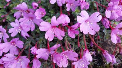
So I dig in with my trekking poles and get going, feeling a little better for the snack, and watching the elevation read-out on my watch (there’s 1,000 feet to go to get back up and over). At the same time, however, there are so many beautiful wildflowers growing among the granite rocks and ubiquitous clumps of sage, it’s hard not to pause every now and then to admire them — and there’s something especially intriguing about these alpine species, because they seem so delicate, yet they must be pretty tough to endure this rough environment. I hustle along, pause to inspect a small plant person, glance up at the morphing cloudscape, and move out again.

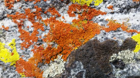
And the granite boulders have such colorful patches of crustose lichen: bright orange, lime green, forest green with brown apothecia, chocolate brown….
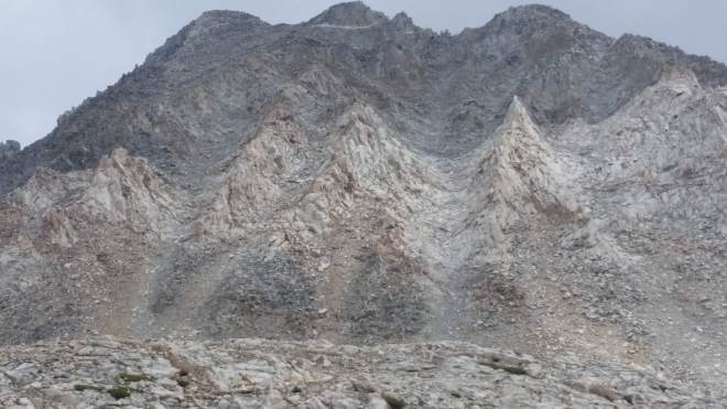
Near the top of the pass, a sidelong glance at the shoulders of Mt. Agasiz: nothing but barren rock, carved into sharp ridges, like knuckles or claws. A ruthless mountain, which would dash a foolish hiker to pieces against those sharp rocks, just like it did to that hapless herd of deer. Although this is not really a fair characterization: water and ice are responsible for disfiguring the peak, leaving it with these scars, the mountain has done nothing but persevere in the face of relentless erosion.
On the descent it gets a little crowded: the deer once again, and a large trail crew from the California Conservation Corps at work on the stone steps and walls (what do you do if there’s lightning, I ask — we go down, they reply). A mule train approaches, I stand to the side. The dark clouds looming above Mt. Agasiz pelt us with some freezing rain. Goretex jacket goes on in a hurry. After a few minutes, the rain clears, and there’s Bishop Lake once again, lying just below, dimly turquoise against the gray-brown rockscape, and beyond it the jagged mountain wall leading up to Mt. Goode on the western side of the pass:

Once down out of the pass and back in the valley, I relax a little and saunter along thinking about campsites. On the way out this morning, I’d noticed a couple of promising sites and marked them on my cellphone map. I’d also noticed some strange-looking plants with white globular flower heads, but hadn’t stopped to look being in a rush to get over the pass. Now, I give one of these specimens the once-over (and eventually identify it as Ranger Buttons, a member of the carrot family).

Walking along, mid afternoon, no storm yet, but a glance over the shoulder reveals clouds bubbling over the ridges, with hammerheads jetting upwards. Surely something’s coming.

Suddenly I realize I’m almost back at the trailhead. Where are those campsites? Frustrating to walk past them without noticing — and doubly frustrating, my cellphone’s run out of power (I forgot to put it on airplane mode) so I can’t look up the locations on the map. Meanwhile, a bolt of thunder and a few spits of rain. It would be somewhat melodramatic to call this a crisis, but time seems of the essence. I stop in my tracks, sit on a rock, take off my pack, dig out the waterproof sack, pull out the battery charger, and plug in the phone. Sure enough, the last campsite is about a quarter-mile back.
I hurry back, scan the area, pick out a site, string up a cord between two trees, and soon enough my little shelter’s up. Whether it will withstand horizontal sheets of wind-lashed rain is open to question, but I’m wearing goretex top and bottom, so what of it. I settle down, heat up some water for tea, and eat my dinner.

Thunder cracks in the west, moves gradually closer across the valley. The rain comes and taps away on the tarp. I observe where drops strike earth and pull my feet in a few inches. And then the rain ceases.
The effects of altitude are unpredictable. Despite several hikes and runs at altitude in the last couple of weeks, today I’m beat. I finish dinner, unroll sleeping bag, go to bed at 6:00 PM and wake up the next morning at 6:00 AM, feeling better. The bear canister spends the night a short distance away, unmolested.
2 miles back out to the trailhead the next morning, and now there’s time for some more exploring. A short drive takes me to Sabrina Lake, where there’s a small shack catering to fishermen. I drink a cup of coffee and get directions to Lake George.
More rain’s expected by noon, but for now the sun’s out and it’s hard not to enjoy the bright light beaming down from a clear sky and gleaming off the granite. I strip down my pack for a short hike, take off my shoes, and head out barefoot along Sabrina’s eastern shore on a path that’s a mix of sand and gravel and few big rocks.

More interesting flowers, including lots of Sierra Angelica (Angelica lineariloba, also called soda straw) lining the trail, in some places leaning out across the path.


The trail reaches a junction and turns sharply upwards, climbing a thousand feet up through a series of switchbacks. Below, Sabrina Lake nestled in a giant bowl, above the ridgeline leading southwest to Mt. Lamarck (13,417 feet), green on gray and dappled with cloud shadows.

Lake George is a long time coming, and thinking once again of the forecast, I’m looking at my watch not wanting to go much past 10:00 AM. Somewhere up ahead is Little George Lake, in a high valley with a rushing stream, wetlands, willow thickets, pine forest, and a mosquito or two. Another fifteen minutes, and this is far enough for today.

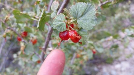
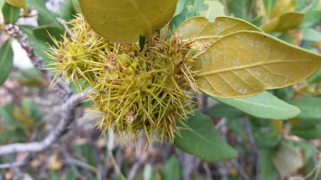
On the way back, so many different flowers and bushes: one with small gray-green fan-shaped leaves and bright red berries; another with spike-balls, but although they litter the trail for a stretch, they aren’t prickly to step on; and purple, red, yellow, and blue wildflowers.

5-mile barefoot hike complete, I drive back into town, return the bear canister, grab an espresso at the local coffee shop, plug into the internet, and plan my next move.
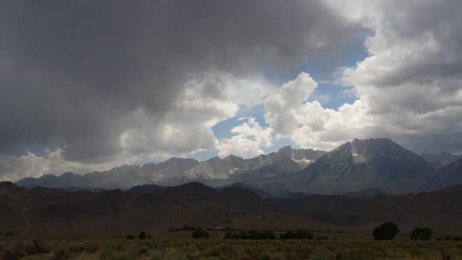
A little later, on the drive north to Mammoth Lakes, heavy gray rain finally moving across the Sierras in the south, while the sun blasts through in the north. Clouds boil above the White Mountains, but deep within the Sierras’ rain shadow, they will get little or no moisture. Desert vistas stretch far to the north, long slopes reaching into the heights, gray-brown with sage, sand, and rock. This valley is enormous. It’s like an amphitheater, within which play out the violent interactions of weather and mountain, water and rock, seemingly unstoppable forces and immovable objects. An extraordinary feeling to witness these powers operating across such a vast space well beyond human scale.
Running the Long Path is available on Amazon (Click on the image to check it out)

I’m glad you got a chance to hike a bit in the Eastern Sierras–including some barefoot miles! As always, I enjoyed your trip report, and especially appreciate that you take the time to identify the “small plant persons” you meet along the way. Happy Trails!
LikeLiked by 1 person