March started out on a difficult note with four different snowstorms — which left me slogging through deep drifts, sinking up to the knees in fresh powder, toiling upwards one step at a time — just miserable hard work. On one hike, I’d set out to climb four peaks but completed only one, which put me behind schedule. As month-end began to draw near, there were seven peaks left — a feasible load — but then conference calls and meetings popped up unplanned for, and time started to get tight. Now there would be little room for error, especially when the longest, toughest hike was left for the last day of the month….
Bearpen – March 23, 2018
A sunny day and mild — the first hike of spring! This is a snowmobile trail, and the snow’s been compacted by the machines whose ski and tread marks dot the surface. No need to clump around in snowshoes, those heavy, clumsy, ankle-torquing devices which I so detest. A brisk power-hike uphill with some slow jogging, too — what a joy to be moving purposefully! — a break from those slogs in deep snow where I’d had to count steps to keep from losing my mind. At a reasonable level of exertion and speed, the mind wanders about easily and the ground streams by like water in a creek.
From Bearpen’s high point, a clear view of the Schoharie Reservoir, about seven miles off to the north, where in a few days I will give a talk on the Long Path at the New York Power Authority Gilboa-Blenheim Visitor Center. I imagine standing out there on the banks of the reservoir, turning south, and scanning for Bearpen — trying to connect the dots….
The hikes ends with me trotting back down the mountain, in a cheerful frame of mind.
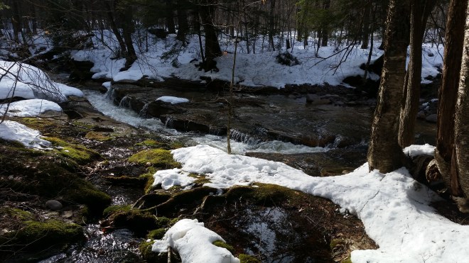
Kaaterskill High Peak – March 23, 2018
The beautiful spring day continues: after Bearpen, I head over to Kaaterskill High Peak.
Once again this is a well-packed snowmobile trail, with no need for snowshoes. I trot along until the left ankle issues a few warning twinges then slow to a walk.
Soon enough I’m at the base of the steep scramble that leads to the summit. Here the path is covered in loose snow, but I really don’t want to put on the detested snowshoes (which are tied to my pack). Instead I struggle upwards ever so slowly, slipping and sliding, and here and there punching holes in the deep snow — this is called “postholing” and is considered bad etiquette because you churn up the smooth packed surface — but too bad, untying the snowshoes and strapping them on would be too much bother, I’d rather keep struggling. Upon reaching an icy rock face, though, some additional traction seems called for, so I unclip crampons from my pack and buckle them on. But soon it’s back to deep snow, and the crampons’ sharp teeth can’t bite into powder. I flail and flounder about, leaving more postholes, and start to feel ashamed of damaging the track…although hopefully this will all be melted in a few days and in any case I’m not the only rascal who’s left a few holes behind.
On the way back down from the summit, I pause to fill in some of the postholes with loose snow and pack it down.
Windham High Peak – March 25, 2018
The drive to the Gilboa-Blenheim Visitor Center followed a long circuitous route into the Schoharie Valley, along high ridges still covered in snow, while fresh flurries blew down from the sky — quite the adventure getting there. Undoubtedly Bearpen was smiling down at me from the heights, but nothing was to be seen through the mists and low clouds.
After my talk was over, I stopped in Middelburgh for a slice of pizza and then drove back to the Catskills through the hamlet of Durham, which sits perched on a high ridge across the way from Windham. Passing through the ski town, I caught a glimpse of the mountain’s spine rising off toward the east looking like the back of some huge dinosaur, with dark green stands of spruce and pine for dorsal fins….
A brisk walk carries me upwards, in a relaxed state of mind. An orange-gold glow of light to the southwest, behind a thin cloud streak, the only mark in an otherwise empty sky. To the east the familiar three humps of the Blackhead, but the patterns have changed: a week ago the boreal fir-spruce thickets on top glowed brilliant white, because the conifers’ branches and needles held so much fresh snow. But now that snow has melted, and the mountains are topped with a band of slate green.
And now at the summit, the sky is darkening, and from different vantage points, a nighttime snowscape stretches around for 360 degrees: to the northeast, the lights of Albany, to the east the Blackhead range and its northern foothills spilling into the valley, to the southwest the scattered lights of the town of Windham. The snow-dusted mountains bulge out under the dim glow of half-moon and stars.
No need for headlamp or flashlight: I walk the 3 miles back to the trailhead in the moonlight, groping more slowly through two stands of spruce and pine, where the trail vanishes momentarily in the shadows.
On the drive home, a fisher (member of the weasel family) is strutting down the middle of the road, as if he owns it, and evidently unimpressed by the car, which I bring to a halt. Dark fur, short ears, long waving tail — what a beautiful animal! Unless you’re his prey!
Indian Head – March 26, 2018
Who schedules a conference call for 4:30 PM? (The answer, busy people working under tight deadlines). My strategy: drive up to Phoenicia in the early afternoon, eat a snack, listen to the call in my car — this puts me at the trailhead a little after 6 PM.
Another nice walk on hard-packed snow, although the trail steepens considerably as it nears the Jimmy Dolan Notch. I hustle along in pursuit of sunset views, but it’s pretty dark by the time I reach the top.
Another walk back in the moonlight, headlamp switched off… a little tricky in the hemlock groves lower down where the path vanishes into shadows….but if it’s not to the right, and it’s not to the left, the chances are good that the path continues forward — and if your foot sinks into soft snow, then take a step back and adjust course.
Doubletop and Big Indian – March 28, 2016
It’s going to be a long bushwhack in thick soft snow. I wouldn’t use the word “concerned,” rather, I’d describe my state of mind as thoughtful and conservative.
On the drive north, the Shawangunks are socked in at 1,000 feet, and the Catskills are invisible. A dark gray layer blocks out the sky. In one spot, the dark gray has separated, and visible up above is another layer, lighter gray and subtly luminous. A tendril reaches down, frozen in mid-grasp.
In some places, birches and other saplings have bent gracefully under the load of ice now melted, but other trees have broken asunder, or their limbs have fractured and cracked, exposing fresh wood. I reflect on this: if these trees were stronger, they wouldn’t suffer so much damage from winter storms, but then maybe they’d grow too slowly and lose out in the competitive race for sunlight. Trees keep growing, even when they lose limbs, and forests move on, even when individual trees succumb — parts and pieces are expendable. In the same manner, take a group of runners, and some will fall by the wayside with injuries. It has to be this way, otherwise it would be the case that nature made us too strong to run fast, or too cautious to compete.
I walk out on a hard-packed trail with a matter-of-face mindset, saving my energy for the bushwhack on top of the mountain. A well-defined track leads me up toward Doubletop. With the temperature in the 40s, I strip off shirt to keep from sweating and suffer nothing worse than occasional cold drops on shoulder or chest.
For a change, there’s no wind. From the mountain’s upper shoulder I look back at banks of white fog massing in the valley to the north.
Reaching the boreal zone, my eyes are drawn to the branches of fir and spruce encrusted with exotic lichens. There are plenty of old favorites here, plus some new species (for me): everniastrum catawbiense, tufts of gray stalks branching like antlers, black on the backside, with tiny black hairs along the edges — and American Starburst Lichen, with wavy curled green lobes and small brown cup-shaped apothecia, which contain the spores.
Now the day’s challenge: a 1.5 mile bushwhack along the ridge and over to Big Indian. I start out tentatively, moving through thick fir and spruce. Once out of the firs, the going isn’t bad at all. Sure the snow is thick and getting slushy as the day warms up, but heading downhill you can take big strides, sink a little here, slide a little there, the snow helpfully covering rocks, branches, and other obstacles.
Glancing to the north, that white fog bank has moved in and is now pushing up against the shoulder of Big Indian. I move steadily along the ridge, and then a little more slowly as I begin the ascent to Big Indian. A little while later I glance to the north again, and the fog has vanished.
Big Indian’s summit is reached in due course. Now it’s decision time: get back on the trail and follow it down into the valley, or take a short cut through the woods, which would be a straight shot down a long ridge. I opt for the short cut, and it works out splendidly: I’m taking long strides down through the thick snow in a relatively open forest — what a wonderful feeling to be moving quickly! Heading down into the valley, surrounded by mountains: Graham on the left, Eagle on the right, blue and white with mist curling along their slopes, while far off in the base of the valley some snow-covered fields are shining bright white (a perfect navigational beacon!), and stands of hemlock gleam slate-green in the hills.
Down in the valley nearing the Shandaken Creek, so many animal tracks in the snow! And then on the drive out a pair of bald eagles, big birds lumbering through the trees, gliding around a field, screaming back and forth to each other.
Friday, Balsam Cap, and Rocky – March 31, 2018
Here it is the last day of the month, and I’ve saved the worst for last: Friday, Balsam Cap, and Rocky lie along what is arguably the most difficult ridge in the Catskills, pathless and full of ferocious fir-spruce thickets.
Choice one: a 2-mile route from Moon Haw, but quite rocky and steep in places, which is unappealing in snowshoes. The alternative is longer but more gradual: following the unmarked Fisherman’s Trail along the Neversink River and then up the easier backside of these mountains. This one seems more prudent.
Arriving Saturday morning at 8:00 in the morning, the sky is clear but the air still quite frosty, and deep snow is waiting right at the trailhead. The surface is crusty and supports my weight without snowshoes, which makes the first couple of miles an easy walk. As sunlight finally begins to filter through into this north-facing valley, I stop to put on snowshoes.
It’s funny, after having commented on birches bent over and caught in the snow, on each successive hike it seems like I’m seeing more and more trees in this condition, only now instead of the white-barked river birches lining the roads, here it’s beech and yellow birch saplings that are bent over in gray arches — in some places there are so many, it’s like walking under a bower or through a tunnel.
After 4 miles, it’s time to head uphill toward Friday, and just as the map suggested, it’s a gentle grade through open forest, and with the snow still firm, a relatively easy walk and always a great joy when you can move fluidly in these mountains. As I enter the boreal zone, the terrain gets a little more tangled with fir and spruce and tumbled sandstone boulders, and care is required to keep snowshoes from getting tangled while squeezing between rocks and small trees, but progress is steady, and eventually I’m standing on the summit.
But Friday isn’t ready to give up without a fight. The canister is located some distance away from the true summit on a ledge that affords remarkable views to the east…..I start making my way in that direction, pushing through thick vegetation, when I hear a call. Other hikers are here and having trouble finding the canister. “This way,” I call back, but the going is difficult and when we finally emerge on the eastern edge of the ridge, there’s no canister. Why not split up, I suggest, two people head a few yards to the north, and two of us, south — because it can’t be far. I head north through a tangle of branches interlaced; I’d taken off my shirt on the climb to avoid overheating, and now I get speared in the shoulder by a broken branch (this earns me a nice bruise) — and still no canister. But then there’s a shout — the other team found it just a few yards away.
Six or eight people are standing around, waiting to sign in on the logbook, but I have two more peaks to go, so I can’t hang around. The view, however, is remarkable and worth a few more seconds. Under the clear sky, it’s like looking out at an enormous amphitheater: immediately to the left, Friday and Wittenberg, two rounded humps that seem almost within reach. Below us the Ashokan Reservoir, sprawling about with tendrils stretching in all different directions (a lazy octopus shape?), and shimmering in different shades of blue — with some of the magical turquoise color I’d seen in the glacial lakes of New Zealand. In the distance, the western flanks of the mountains of the Devil’s Path, frosted blue and white on the top.
To get from Friday to Balsam Cap, last time I’d steered west and run into cliffs, so this time I drop down the eastern flank, searching for a chute that runs diagonally between sheer cliffs that are almost 50 feet high. I clump and slide through the snow, which is turning soft and wet under the strong spring sun, but find myself at the top of those cliffs and don’t like what I see looking down the sheer rock faces. I retreat and decide to head a little more east, and am soon back on the summit, out of breath and feeling somewhat confused. It’s time to calm down, pull out the phone, and take a closer look at the location of that rock chute, which was indicated with a drop pin on the map. It isn’t far.
Back to the cliffs, I find a place to scramble down (have to take off snowshoes, though, and throw them down a ten-foot cliff), and then moving southwest, here’s the chute — it’s unmistakable, a marvelous 45-degree ramp that takes you down past rock walls that seem at least 100 feet tall (they’re not). Everything’s covered with deep sloppy slush, just perfect to stumble down and skid along.
From here, a pleasant walk down to the saddle, and then up to Balsam Cap — after so many misadventures on this ridge, I’ve learned the trick (stay to the eastern edge of the ridge, where the fir and spruce aren’t so thick). This strategy takes me on to Rocky, and what a delight to move through this forest without getting snagged.
Now it’s time to drop down Rocky’s backside into the valley of the Neversink, and retrace my steps back to trailhead and car. Dense fir and spruce soon fades into an open deciduous forest, and it’s an easy march down. I feel like I’m in a big bowl: across the valley looms Slide’s summit, looking a little double-humped from this angle, to the right is Cornell, and off to the left is a hint of Lone’s fir- and spruce-clad summit. Way off in the distance, another double-humped peak is sticking up over the ridgeline (I measure an azimuth and once back home confirm this is Doubletop, seven miles distant).
A long 4.5 miles back along the Neversink, and not unexpectedly the hard crusty snow has morphed into heavy wet slush, and each step becomes a struggle. Misery! I don’t totally lose my cool, because I knew this was going to happen, but my equilibrium waivers…like an engine that stutters….or lights that flicker once or twice.
There are some positives. For one, I’m following some different tracks on the way back and seeing different parts of the valley and learning some of the better routes.
Another positive: passing that magical spot in the Neversink where the water pours through a narrow channel in the sandstone slabs. Where the water pools you can see the river bottom — more slabs — the water’s so clear. Across the river, a grove of hemlocks: the perfect place to camp on a warm summer evening after a dip in the cool water.
And so ends March, with visions of camping in the summer. Yet now that April’s finally here, it’s snowing again. Patience!
Running the Long Path is available on Amazon (Click on the image to check it out)
