Emboldened by the successful completion of Rocky Peak and Giant Mountain, I laid out plans for an overnight hike that would bag me three more of the ADK High Peaks: Wright, Algonquin, and Iroquois, with an option to bag a fourth, Mt. Colden, if all was going well.
- I arrived at the Adirondack Loj parking area a little after 7 am.
- For the first mile, the trail was beautiful soft dirt; there’s no better surface for barefoot hiking.
- After the first mile, however, the trail became more washed out and was full of large rocks. However, these were smooth and easy enough to step across.
- Then the trail turned more steeply uphill, and I was clambering up boulders while water trickled downhill. Many of the steepest Adirondack trails seem to end up functioning effectively as streams, and over time they get more and more washed out until they’re nothing but tumbles of rocks. Then they widen out over time as people seek routes to the sides where they can step on dirt and grab onto vegetation.
- Nonetheless, I was able to keep up a good pace. Going uphill without shoes is easier than downhill, because the foot strikes with much less impact. This morning I passed several shod hikers, which was admittedly rather fun.
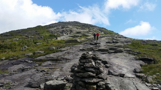
- After an hour or so of upwards progress, a sign indicated 0.4 miles to Wright, my first objective, and a final scramble up exposed rock faces brought me to the top. The wind was blowing fog across the summit, and there was nothing to see. During the climb I’d stripped off my shirt to stay cool, but now I felt myself rapidly getting chilled — in fact, the physical stress of the cold air and the mental stress of going barefoot left me feeling a little nauseous. In training some stress is good, but too much can be counterproductive, and in the back country extra caution is always warranted — and so back on went the shirt, and then a sweater, and then a goretex shell. Even so, I didn’t tarry at the summit, but turned right around, and a few minutes later started to feel warm again and all the extra clothing came right back off.
- On the way back down from Wright I passed a young couple who’d I seen earlier. They were heading in the same direction as I, but admitted they were feeling pretty tentative given the conditions and were no longer confident in making it to Algonquin.
- Back on the main trail, Algonquin was only a short distance away, but it entailed another 1,000 feet or so in climbing. It was back to clambering over boulders and stepping through puddles. Once at the top, the gray fog came scudding across, and a cold wind whipped past me, and all the warm clothing went back on plus I zipped on long pant legs to my shorts.
- I’d climbed Wright and Algonquin last summer, but now it was time to plow on into the unknown. Specifically I was looking for an unmarked trail that would take me on to Boundary and then Iroquois Mountains. I took a few tentative steps into the mist and then down the backside of Algonquin, following a series of cairns and yellow paint stripes, finding the rock slabs were a little prickly in bare feet but offered plenty of traction. Suddenly the mist cleared, the sun lit up the landscape, and there were Boundary and Iroquois straight to front, with cloud shadows flashing across the ridge, while behind me I could see hikers standing on Algonquin’s summit and descending toward my location.

- With the sun out now, I paused to examine some of the crustose lichens that spattered the rocks in lime-green and gray. A couple of hikers passed me and one asked pointedly, “please tell me you have shoes in your pack.” I paused for a moment and then replied in the affirmative. A little while later I overtook them on the way to Boundary. As mentioned earlier, it’s great fun when hiking barefoot to pass people in more conventional gear: heavy boots, gaiters, trekking poles, etc.
- The unmarked trail to Boundary and Iroquois was easy to find, and to my surprise, it seemed in as good condition as the official trails I’d hiked: the vegetation had been trimmed back, cairns had piled up to show the way across exposed rock slabs, there were paint stripes on the rocks, and most surprising of all were recently installed wooden planks across muddy sections.

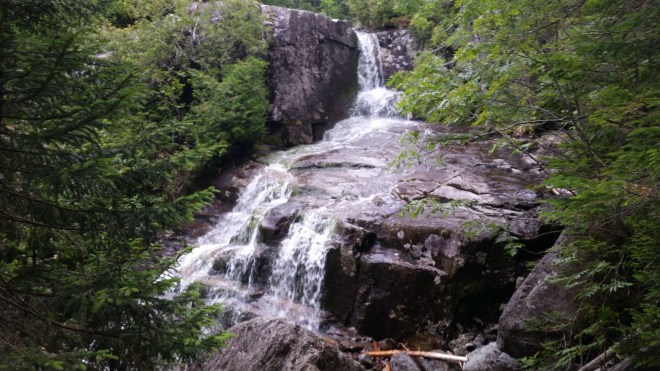
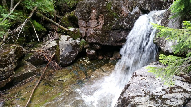
- It didn’t take long to reach Iroquois and then return to the saddle below Algonquin. Now it was time to descend some 2,000 feet to Lake Colden, and here the trail was altogether another story. At first it wasn’t too bad; I stepped from rock to rock at a reasonable pace and overtook a group of slow-moving hikers. But then the trail deteriorated into a tumble of rocks with water rushing in between and around them. Then it began criss-crossing a roaring creek, and in some sections it effectively merged with the creek.

- It would have been slow even with shoes, the challenge being not so much the roughness of the rocks, but the big boulders you have to navigate while dropping steeply down the mountain, and in bare feet, you can’t jump, and you can’t afford to lose your balance. I focused on the task at hand and tried to relax and for a period of time kept up a slow but steady pace, periodically glancing at the altitude displayed on my GPS watch to gauge progress, until around 3,500 feet, when my pace slowed to an absolute crawl. I was lowering myself from boulder to boulder, on my butt in some places, or using hands and feet in a modified downhill crab-walk. This was beyond slow.
- But there was no rush. It was still early, and I had nowhere to go but a lean-to that evening.

- A young fellow came charging up the trail, sweat pouring off his face, carrying no gear except a water bottle.
- Then I encountered an older couple. They told me this section of the trail was the steepest two-mile stretch in the Adirondacks.
- As the stream rushed down the mountain, a spattering of rain hit me and I stopped to put on sweater and jacket. The cloud passed, I felt uncomfortably warm, so I stopped to take them off again.
- I sat down for a moment to admire a sheer rock face over which the water was pouring. Underneath the water, large tendrils of moss were growing on the rock, and it seemed remarkable that the moss wasn’t swept away by the torrents of water, but evidently it had a tenacious grip on the stone and it must have really appreciated the quantity of moisture and sunshine this spot afforded. There was something calm and cheerful about this section in the stream, and I was tempted to hang out here longer, but the runner in me piped up and argued that if I was going to have a chance to climb Mt. Colden, I’d better to get moving.
- The young fellow returned on the way down. He told me that from the summit of Boundary, he’d seen bad weather moving in from the west.
- Eventually the trail began to level out as it neared Lake Colden. I breathed a sigh of relief now that the nightmarish descent was over, but I was in for a rude shock: as the path circled Lake Colden, yes it was finally flat, but the surface was atrocious: more tumbles of rock, and in between huge quantities of deep, soupy, black mud. To a certain extent mud is fun barefoot, but you have to be careful of rocks and sticks lurking underneath the smooth black surface, and you don’t want to lose your balance and fall over, which would be dangerous and embarrassing. It didn’t help that fir trees had been cut down and laid across the muddiest sections, because these had rotted and sunk into the soup, creating potentially dangerous obstacles underneath.
- After the difficult descent down this mountain, my patience began to fray, and my energy level dropped. I decided to skip Mt. Colden.
- As the trail proceeded toward Avalanche Lake, it was evident that a great deal of improvements had been put in: now there were wooden planks across the worst mud, and also bolted to sheer rock faces above the lake, and ladders and steps on the steepest parts. This was a little bit faster, and almost fun, but I was tired, I didn’t want to navigate an obstacle course or climb a jungle gym — I just wanted to walk on a real trail for a change.

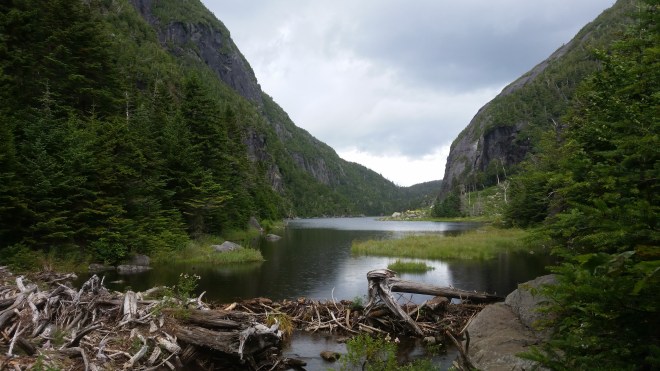
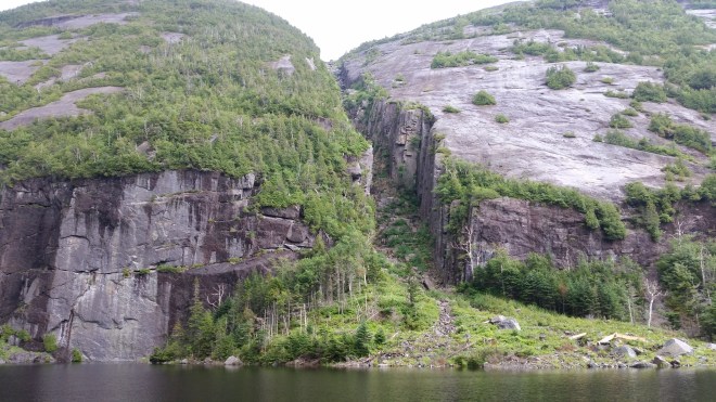
- Avalanche Lake itself was beautiful, and there was a striking cleft in the rocks at the base of Mt. Colden. But I was glad to reach the end of it, which meant only a mile or two to Lake Marcy, where I planned to find a vacant lean-to.
- Now it began to rain. One section of the trail had recently been improved, and the surface was a wonderful spongy mix of dirt and sand. But after this, the trail became gravelly, which is the worst possible surface without shoes. Maybe my feet were just plain tired after nine or ten miles of very rough terrain, or maybe it was the mental strain of watching every single step. I was going very slowly at this point and wondering if I’d ever make it to the lean-to.
- There was a shout behind me, and the young couple I’d seen earlier overtook me. They had persevered and not only reached Algonquin, but also climbed Boundary and Iroquois, and then dropped down the nightmare trail to Lake Colden. They said that they had periodically seen my footsteps on the trail and that these had been a “beacon of hope” to them. This was perhaps the nicest comment I’ve ever heard while out on the trails. I wished them a great hike and waved as they disappeared.
- Finally arrived at a lean-to around 6:00 PM. Without a bear canister, I hadn’t brought any food, so dinner was limited to a cup of tea. And then I went to bed and hiked back out to the ADK Loj early the next morning.
Running the Long Path is now available at the Bookstore Plus in Lake Placid, NY, but if you’re not nearby, you can order it on Amazon
