Slide Mountain is the Catskills’ highest peak, and one I’ve climbed many times, including both summer and winter, day and night — but always following the trail from Big Indian Valley. One day I was rereading “In the Heart of the Southern Catskills,” John Burroughs’ account of his first ascent of Slide Mountain in 1885. Burroughs had long been intrigued by Slide, but he wasn’t going to take a trail. Rather, he chose the more remote Woodland Valley as his starting point and then made his way to the summit through unmarked forest. Moving off trail like this is today called “bushwhacking,” and depending on the terrain, it can be exhilarating — or extremely challenging.
I put down the essay and thought for a moment. As a member of the Catskill 3500 Club, I had climbed the 35 highest peaks in the Catskills, of which a dozen or so require bushwhacking because there is no trail. But it had never occurred to me to seek a bushwhack route when an established trail was available. Why would you do that?
Then a light bulb went off: because it would be a totally new experience.
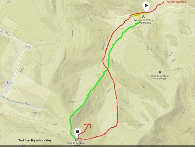
Pulling out the map, I measured a straight shot from the Woodland Valley Campground to Slide’s summit, about 2.5 miles in distance and 2,000 feet in elevation gain. Towards the top, the grade got steep, I noticed, exceeding 40% in places.
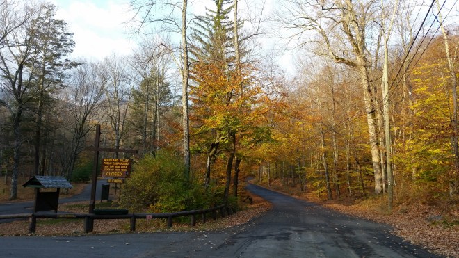
Two weeks later, a little before 9:00 AM, I was pulling into the parking area at Woodland Valley Campground to meet my friend Alan. Our goal: to reenact Burroughs’ bushwhack ascent of 1885 …

There were several reasons behind Burroughs’ particular choice of route. For one, Woodland Valley was one of his favorite spots in the Catskills. He loved “its fine trout brook, its superb mountain scenery, and its sweet seclusion.”
Burroughs appreciated that moving through the Catskills’ thick, tangled, primitive forests would pose a special navigational challenge, which I think appealed to him because it would be a chance to experience nature in a totally untamed state.
One would think nothing could be easier to find than a big mountain, especially when one is encamped upon a stream which he knows springs out of its very loins. But for some reason or other we had got an idea that Slide Mountain was a very slippery customer and must be approached cautiously. We had tried from several points in the valley to get a view of it, but were not quite sure we had seen its very head. When on the Wittenberg, a neighboring peak, the year before, I had caught a brief glimpse of it only by climbing a dead tree and craning up for a moment from its topmost branch. It would seem as if the mountain had taken every precaution to shut itself off from a near view. It was a shy mountain, and we were about to stalk it through six or seven miles of primitive woods, and we seemed to have some unreasonable fear that it might elude us.
Bear in mind that in the late 19th century, people didn’t have GPS or topographic maps, so getting disoriented would have been a very reasonable concern.
We had been told of parties who had essayed the ascent from this side, and had returned baffled and bewildered. In a tangle of primitive woods, the very bigness of the mountain baffles one. It is all mountain; whichever way you turn-and one turns sometimes in such cases before he knows it-the foot finds a steep and rugged ascent.
I could relate to his comment, because even with GPS, I’ve found myself veering off-course when bushwhacking and sometimes getting turned around. In rugged terrain even small mistakes can prove costly in terms of time and effort. A more open landscape would allow the bushwhacker to spot key terrain features and then locate them on the map, but in the Catskills, the views are more often than not cloaked by thick vegetation or blocked by steep slopes.
The eye is of little service; one must be sure of his bearings and push boldly on and up. One is not unlike a flea upon a great shaggy beast, looking for the animal’s head; or even like a much smaller and much less nimble creature,-he may waste his time and steps, and think he has reached the head when he is only upon the rump.
Burroughs had climbed Slide in June, but it was late October when Alan and I arrived at the Woodland Valley campground, which was already closed for the season. The forest had lost much of its foliage, but the beech trees still held on to their leaves. The sun peaked over the far ridge, and the trees glowed in the morning light.
On the drive in, Alan had noticed a sign to Larkin Farm Road just before the campground. Burroughs had pitched his tent at Larkin’s farm the night before his attempt on Slide. Farmer Larkin had explained to Burroughs that Slide lay between two streams and offered his son to guide him to the “forks.”

After assembling our gear, Alan and I set out in search of the forks. We tried to follow the Woodland Valley Stream but quickly ran into private property. This required a change in course: we crossed to the far side of the stream and clambered up a steep bank, keeping outside a series of “no trespassing” signs. After floundering for a bit on a rocky slope, we discovered an old logging road, unmarked but still graded and clear of growth, which we followed up the side of a hill. From here we caught views of Giant Ledge and Panther Mountain looming on the far side of the valley. I had been up those peaks many times and always stopped on the high vantage points to peer down into Woodland Valley, and now for the first time I was staring back up.

The detour on the logging road added some elevation gain to our route, but we were able to skirt the private property. After a little while we turned off the old logging road and made our way back down into the valley, where we found what we thought must be the forks that Burroughs had been aiming for. He had fond words for the stream:
How clean it looked, what purity! Civilization corrupts the streams as it corrupts the Indian; only in such remote woods can you now see a brook in all its original freshness and beauty. Only the sea and the mountain forest brook are pure; all between is contaminated more or less by the work of man. An ideal trout brook was this, now hurrying, now loitering, now deepening around a great boulder, now gliding evenly over a pavement of green-gray stone and pebbles; no sediment or stain of any kind, but white and sparkling as snow-water, and nearly as cool. Indeed, the water of all this Catskill region is the best in the world.

The summer and fall have been very dry this year, and we found barely a trickle of water in the stream, but even so it was quiet and unspoiled, indeed there were no signs of human visitation.
Farmer Larkin’s son had guided Burroughs to the forks, but having reached this point, he departed for home. Now it was time for the navigational challenge to begin. Burroughs found himself in a “bewildering maze of underbrush and great trees, and the way did not seem at all certain.” Looking around, he discovered a line of blazed trees, which he followed for a short distance. Then he turned left and began making his way up the mountain. This was “steep, hard climbing,” he wrote, and Alan and I found that this was very much the case. In some spots I was scrambling on all fours.
We pressed on, and the slope gradually leveled off. With the advantage of maps and GPS, I knew that we had about 2,000 feet of climbing, so I settled in to a steady pace, while Alan ranged ahead. At first the forest was open, but then we found ourselves struggling through beech suckers (these tend to sprout in profusion when the mature trees are threatened with disease). Next was a thicket of yellow birch saplings and hobble-bush. We edged around rock ledges, climbed over fallen trees, and stepped through dried leaves and beds of shining club moss.
Burroughs spent three hours climbing, at which point he emerged into a dense growth of spruce. “The moss was deep, the ground spongy, the light dim, the air hushed. The transition from the open, leafy woods to this dim, silent, weird grove was very marked. It was like the passage from the street into the temple.” Spruce is characteristic of boreal or northern forests, remnants of which cloak the upper elevations in the Catskills. It took about three hours for me and Alan, too, to reach the boreal environment on Slide’s shoulder. Here we discovered a dark green forest of balsam fir; the ground was covered in in moss and mats of decaying ferns which had wilted with the end of summer and dotted with patches of snow left over from a storm a few days earlier. Looking up and to the left, we finally caught a glimpse through the trees of our elusive objective, Slide’s summit.


After the spruce forest, Burroughs encountered the “battlements” of Slide:
The quite and repose of this spruce grove proved to be the calm that goes before the storm. As we passed out of it, we came plump upon the almost perpendicular battlements of Slide. The mountain rose like a huge, rock-bound fortress from this plain-like expanse. It was ledge upon ledge, precipice upon precipice, up which and over which we made our way slowly and with great labor, now pulling ourselves up by our hands, then cautiously finding niches for our feet and zigzagging right and left from shelf to shelf. This northern side of the mountain was thickly covered with moss and lichens, like the north side or a tree. This made it soft to the foot, and broke many a slip and fall. Everywhere a stunted growth of yellow birch, mountain-ash, and spruce and fir opposed our progress. The ascent at such an angle with a roll of blankets on your back is not unlike climbing a tree: every limb resists your progress and pushes you back; so that when we at last reached the summit, after twelve or fifteen hundred feet of this sort of work, the fight was about all out of the best of us.

Alan and I encountered similar battlements: great sandstone blocks dripping with moss and fern, speckled with lichen, and sprouting small trees at strange angles. Sometimes we came upon sheer cliffs reaching thirty feet tall, forcing us to work our way around to the left or right, searching for a cleft or chute that wasn’t too steep or offered a handhold in the rock or a convenient root or stem.
The battlements eventually gave way to a spur that angled steeply upwards through a thicket of shorter, stunted fir trees, and we knew we were close to the summit. A few minutes later, we stumbled onto the trail from Big Indian Valley, only a few yards from the top of the mountain, just as a family of day-hikers was making their way back down the mountain, but they didn’t seem surprised that we had popped out of the woods, or perhaps they didn’t notice.
The last few yards of trail wound across rough sandstone conglomerate, and the path was sandy in places and littered with gravel. Burroughs had commented on this particular composition, which in other locations (for example, eastern Pennsylvania) is often found beneath coal deposits:
The rocks on the top of these mountains are quite sure to attract one’s attention, even if he have no eye for such things. They are masses of light reddish conglomerate, composed of round wave-worn quartz pebbles. Every pebble has been shaped and polished upon some ancient seacoast, probably the Devonian. The rock disintegrates where it is most exposed to the weather, and forms a loose sandy and pebbly soil. These rocks form the floor of the coal formation, but in the Catskill region only the floor remains; the superstructure has never existed, or has been swept away; hence one would look for a coal mine here over his head in the air, rather than under his feet.

At the top, we paused at a vantage point slightly to the west of the summit. The sunny morning had clouded over, but underneath the layers of clouds the Catskill mountains rolled out towards the horizon. Then we stepped onto the rocky outcropping beneath which Burroughs sometimes camped and which today carries a plaque in his honor (in fact, the entire range of mountains including Slide, Cornell, and Wittenberg is called the Burroughs Range in his honor). When Burroughs reached the summit in June of 1885, he reported:
We saw the world as the hawk or the balloonist sees it when he is three thousand feet in the air. How soft and flowing all the outlines of the hills and mountains beneath us looked! The forests dropped down and undulated away over them, covering them like a carpet. To the east we looked over the near-by Wittenberg range to the Hudson and beyond; to the south, Peak-o’-Moose, with its sharp crest, and Table Mountain, with its long level top, were the two conspicuous objects; in the west, Mt. Graham and Double Top, about three thousand eight hundred feet each, arrested the eye; while in our front to the north we looked over the top of Panther Mountain to the multitudinous peaks of the northern Catskills. All was mountain and forest on every hand. Civilization seemed to have done little more than to have scratched this rough, shaggy surface of the earth here and there. In any such view, the wild, the aboriginal, the geographical greatly predominate. The works of man dwindle, and the original features of the huge globe come out. Every single object or point is dwarfed; the valley of the Hudson is only a wrinkle in the earth’s surface. You discover with a feeling of surprise that the great thing is the earth itself, which stretches away on every hand so far beyond your ken.

Burroughs put up with a cold and rainy night on Slide, and as Alan and I were standing on the summit, the rain caught up with us, too, and we didn’t stay long. Burroughs had returned to Woodland Valley by moving down the north face of Slide Mountain, choosing a route across the large landslide which had occurred in 1819 (and which gave the mountain its name). But Alan and I had had enough bushwhacking for one day, so we took advantage of the trail, which returned us to Woodland Valley via the summits of Cornell and Wittenberg. We paused on Wittenberg, as the clouds parted momentarily and the rain paused, to watch mist blowing across distant ridges, and then we moved on again. Catskills weather patterns are evidently just as fickle today as they were 131 year ago:
As we paused, after some minutes, to select our course, one of the finest surprises of the trip awaited us: the fog in our front was swiftly whirled up by the breeze, like the drop-curtain at the theatre, only much more rapidly, and in a twinkling the vast gulf opened before us. It was so sudden as to be almost bewildering. The world opened like a book, and there were the pictures the spaces were without a film, the forests and mountains looked surprisingly near; in the heart of the northern Catskills a wild valley was seen flooded with sunlight. Then the curtain ran down again, and nothing was left but the gray strip of rock to which we clung, plunging down into the obscurity.

Upon returning to the campground, Alan and I congratulated ourselves on a successful reenactment of Burroughs’ 1885 climb. But a few days later, I learned that our route was not correct. Conferring with Woodland Valley historian Paul Misko and Catskills forest expert Mike Kudish, I discovered that the route we had taken is known as Newman’s Route, after another 19th century outdoors enthusiast. Burroughs had climbed Slide on the next ridge to the east, arriving in the saddle between Slide and its neighbor Cornell and then moved west through the battlements to the summit.

When I heard this, I wanted to return to Slide immediately and climb it the right way. But then a better idea occurred: if I returned in June, the same month as Burroughs’ ascent, the whole experience would be more authentic.
Check back next summer!
(And don’t forget to check out Running the Long Path — now available on Amazon)

[…] of other American nature-lovers like Henry David Thoreau who explored the wilds of Maine, or John Burroughs who tramped through the Catskills’ primitive forests, or John Muir who ranged throughout the […]
LikeLike