
As race director for the SRT Run/Hike, I’m interested in encouraging participation in the event and seeing more people experience the Shawangunk Ridge Trail (SRT), which is one of my favorite trails in New York. To be fair, the full 70-mile division isn’t for everyone: not only does it require significant endurance to cover such a long distance, but also you’ve got to be mindful about navigation, nutrition, and hydration, since we don’t provide aid stations or course markings. This isn’t everyone’s cup of tea.
But the half-marathon division should be accessible to a lot of people, and with a start-time of 10:30 AM and the final cut-off at midnight, you have 13.5 hours to complete the course, which requires moving at barely a 1 MPH average pace. To demonstrate just how generous this time limit is, I chose a beautiful fall day recently to see if I could complete the 1/2 marathon course within the time limit, without food, water,* or even shoes.
As a novice barefooter, I knew the going would be slow, but I couldn’t think of a better way to spend the day than experiencing the sights, sounds, and textures of New York’s most magical trail.
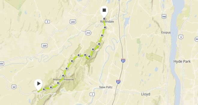
The adventure started at 8:30 AM, when my wife dropped me off at the Peterskill entrance to Minnewaska State Park Preserve. I crossed the parking lot and reached a red-blazed trail, which is the start line for the race. After clicking the button on my GPS watch and removing my LUNA sandals, I strode forward — and immediately winced in pain — as I encountered a hard-packed surface covered in gravel. After a few yards, however, the gravel gave way to fine shale grit, which was much more pleasant, and off I went in high spirits, admiring the fiery red leaves of maples and cherry trees.

The trail circled uphill and to the right, and the blazes changed to white. Soon the trail passed through a wide meadow with blueberry heath and cherry trees that had turned scarlet set off by a patch of pale yellow ferns that were beginning to wilt.

After a half mile, I reached High Peter’s Kill, which is a secluded notch on the top of the ridge, shaded by trees and a wall of layered rocks. Here was the junction with the Shawangunk Ridge Trail (SRT), which the race follows all the way to its northern terminus at a restored railway bridge in Rosendale, New York.

Turning right, I followed the SRT along a gradual downhill grade through a thick growth of blueberry. The path became rocky, and then it dropped steeply down the side of the ridge along a rough stone staircase fashioned from chunks of conglomerate. I gritted my teeth and stepped carefully onto the rough pebble-crusted surfaces, lowering myself down one step at a time.

Upon reaching the bottom of the valley, the path was mostly dirt, and I was able to trot along briskly for a few yards before thick tree roots slowed me down again. My watch beeped, indicating the first mile was complete, with a little more than 12 to go. At this point the SRT left Minnewaska and crossed into the Mohonk Preserve. A little while later, the trail hopped onto a “bog walk” built over a muddy stretch of ground, and I stepped carefully along the wooden planks keeping an eye out for protruding nails.

The trail crossed Clove Road and passed through a grassy field. I took this opportunity to jog through the grass, avoiding gravel on the trail, then crossed a bridge over the Coxing Kill. A little while later, my watch beeped again, signaling the completion of mile two. For a time, the path was beautiful smooth dirt, covered in places with fallen leaves, including plenty of maple. After a little while, the trail headed uphill and turned rocky. Where possible, I stepped along the grassy shoulder, but when vegetation crowded in on the sides, I was forced to step carefully through gravel and rocks, and my pace slowed.

The trail alternated between dirt and rocks, and my progress was steady if not quick. Eventually I arrived at the turn-off from Old Minnewaska Trail onto Undivided Lot Trail, a turn that runners frequently miss during the race, even though it is marked with SRT blazes. Sometimes turtles see things that hares may miss.
The miles passed slowly, and the trail meandered through a glade of common hay-scented fern, which had turned from green to pale tan.

Undivided Lot Trail takes you down the shoulder of the ridge and from certain vantange points reveals vistas of the Catskill Mountains, which loom in the distance beyond the neighboring valley. From time to time a raven would croak or a jay would cry out overhead.

After this vantage point, the trail clambered up through some rocks, but then turned downhill, and the surface shifted back to dirt, allowing me to jog slowly along for a period of time until eventually I reached a paved road. My watch read 6.5 miles; I was close to the half-way point.

After a short distance along the pavement, the SRT entered a tree-lined tunnel and proceeded along Chapel Trail. Most of the trees were still green, although many of the beech had turned yellow, and here and there were maples, staghorn sumac, and virginia creeper that had turned bright red.

The trail emerged from the woods at Spring Farm, which is the site of a the last checkpoint in the race, and then ascended Crag Trail through a meadow of goldenrod. Crag Trail ended on a carriage road, and once again I was picking my way across a gravel-covered surface, grimacing with each step, but it only lasted 1/2 mile before the course dropped back onto a narrow footpath.

The path was rocky and it dropped downhill to the base of the ridge, and then it was time to clamber back up through a jumble of conglomerate boulders. Stepping from rock to rock felt a little bit like climbing on a jungle gym. Barefoot hiking teaches you balance, because you can’t afford to slip around.


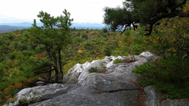
Once on top of the ridge, the trail alternated between dirt and rocks, and some sections were covered in pine needles — a treat for tired feet! A vantage point revealed more vistas of the distant Catskills, while the path leaped across broken conglomerate slabs with deep fissures between the rocks.


In due course, I arrived at an intersection with an old forest road that would take me to the finish. My watch showed 10 miles done, which meant there were less than four to go. But when I saw the time, I realized I’d need to move purposefully, as my wife was due to pick me up at the finish around 5 PM, and I didn’t want to keep her waiting.
The forest road led downhill and into a swampy area with a grove of hemlocks on one side and a small stream on the other. I stepped through a patch of cool mud that was criss-crossed with the tread marks of mountain bikes.


After a mile or so, the forest road turned back into an official trail marked with dark green blazes, and then it passed a rocky vantage point with views to the north. Continuing downhill, the trail eventually exited the Mohonk Preserve and joined the Wallkill Valley Rail Trail. There was now less than a mile to the finish. I was bracing for the gravel and rocks that often cover rail trails, but to my delight, it was smooth dirt covered in fallen leaves.
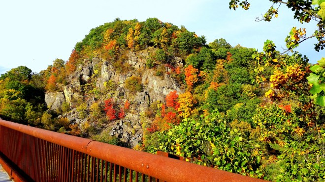
After a short distance, I arrived at the restored railway trestle and marched out across the slanted wooden planks, head held high — being careful not to look down down at the Rondout Creek some 150 feet below. The clouds had cleared, and the sun was now low in the sky, streaming across the valley, and lighting up the cliffs on the far side of the trestle, where maples growing among the rocks were glowing orange and red.

From the trestle to the race’s finish line is a quarter mile, and this last stretch was covered in mounds of gravel. Each step was painful, especially after a long day on my feet. I hobbled to the finish, put on my sandals, and met my wife.
My total time was almost 9 hours, equivalent to an average pace of 1.7 MPH. For some perspective, this would have put me in last place in the 1/2 marathon division in each of the two years we’ve run this course. But that’s fine. I would still have had 4.5 hours to spare to complete the event within the cut-off.
I invite you to come on out and hike or run the SRT on your own, or join us Saturday, September 16, 2017 for the race. By all means, feel free to bring food, water, and a comfortable pair of shoes. You’re sure to have a great time.
* Regarding water, as a precaution I carried 1 liter, but since it was a cool day (in the 50s) and overcast, I didn’t end up drinking any.


[…] Liked Kenneth Posner's Hiking the SRT 1/2 Marathon Course […]
LikeLike
[…] around the edges. On my next hike, I discovered a stand of crimson-leaved cherry standing over a field of scarlet heather. And then it seemed there were cherry trees blinking everywhere in the woods, and cherry leaves […]
LikeLike
[…] performance by 30-mile runner Su Mittra, who completed the course barefoot. Having myself barefooted certain sections of the trail, I was astonished by Su’s speed over a pathway that is full of gravel and rocks […]
LikeLike