To learn something new, take the path you took yesterday.
— John Burroughs
The week-long holiday break was time well spent with family, friends, and new acquaintances, relaxing, talking, celebrating, eating, drinking, hiking, and running.
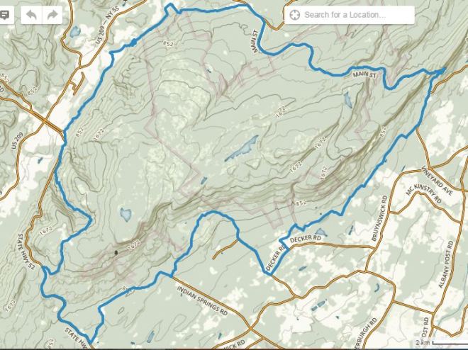
And I was able to fit in one run that was a little longer than average and extra special: a 42-mile circumnavigation of the Northern Shawangunks, on roads that parallel and then cross over the mountains. To make life interesting, I brought no food or water.
I had run this route before in March 2014, almost two years ago. The impressions from this tour of the mountains were still vivid in my mind, and I was eager to see the sights again and make new observations.
Why no water? With a forecast high of 37 F, I didn’t think I’d get thirsty. Just in case, I brought a water filter to drink from streams.
Why no food? I train without calories to develop fat-burning as my primary energy source. And since I was planning to run at a moderate pace, I didn’t think I’d get hungry. Just in case, I could buy food from a deli.
With a familiar route and a short packing list, there wasn’t much to do but get started. When morning arrived, however, the sky was so grey and murky, I hesitated. Finally, about an hour later than planned, I headed out into the mist.
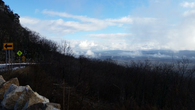
A quiet road led me through mixed hardwoods, and while fog loomed above, the sun was just breaking through clouds along the horizon. The light streamed into the forest almost horizontally, illuminating clumps of brown leaves and making them glow warmly. Branches of lichen-crusted trees gleamed pale green.
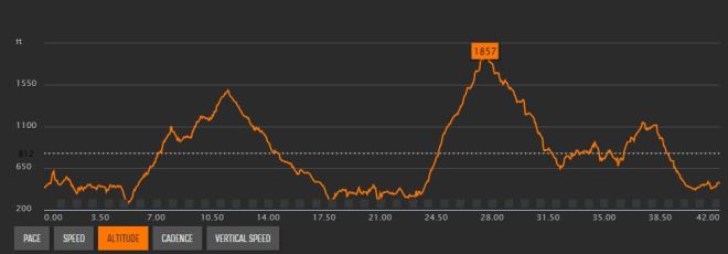
After seven miles, the road turned onto Route 44-55, a two-lane highway that climbs 1,200 feet into the mountains. The highway wound its way upwards in the shadow of the ridge, but down below sunlight streamed across the valley, and the mists were breaking up.
Periodically my watch beeped, ticking off another mile, but my concentration was fixed on the traffic. Local drivers are normally courteous, but today they wouldn’t yield an extra inch. Maybe they were preoccupied with the holiday.
The climb continued. It was cold in the shadows, and the wind spilled over the high ground, chilling me further. The sun peaked above the treeline for a moment and warmed my back — but it was just a tease, and a moment later clouds spread out and blocked the light. I was running easily, but I wanted to be running faster. It suddenly became important to beat my time from two years ago, although I didn’t remember it and had no specific goal for today.
Eventually, the highway crested the ridge and began the long descent into the Rondout Creek Valley. Twenty-five miles to the north, the Catskills stood out against the morning sky, speckled with blue. With the winter sun low in the southern sky, the shadow of the Shawangunk Mountains stretched half-way across the valley.

The descent continued for a few more miles before a side-road took me off the highway and onto a quiet country road on which is situated a Ukranian cultural heritage center called Soyuzivka. Across the street stood a Ukranian church with a banner proclaiming its fiftieth anniversary.
Another mile passed, and the route turned southwest onto Berme Road, which clings to the base of the mountain. Streams poured down the slopes, splashing over stone ledges. An intermittent ice-covered ditch was visible in the woods. This is all that remains here of the D&H Canal, which was a major artery of commerce during the 19th century.
Two years ago I had passed a strange site on Berme Road, and here it was again, seemingly unchanged, consisting of plastic flowers and other decorative touches. This time I paused to read the words on a small plaque: “We’ve been through a lot together — and most of it is your fault.”

The road passed a trailhead for the Long Path, snaked through a collection of small and derelict homes, then curved behind the Eastern Correctional Facility, a massive 19th century gothic structure surrounded by guard towers, stout walls, and acres of barbed wire. And then I found myself abreast of Berme Road Park (the site of the Ellenville Mountain Running Festival), turning left onto Canal Street, merging onto Route 52, and then heading up the incredibly steep South Mountain Gully Road, which inflicts a punishing 4-mile, 1,500-foot climb with an average grade of 7%. I ran the whole thing, albeit slowly, rejoicing that it was the last major climb of the day. The road passed streams, occasional houses, a deep ravine, and another trailhead for the Long Path (this one familiar to participants in the 70-mile Shawangunk Ridge Trail race), before cresting the ridge in the hamlet of Cragsmoor.
Once past the top, a vantage to the southeast opened up, and the plains of the Hudson Valley lay stretched out before me. The sky was now deeply overcast, but a band of luminescence marked the horizon, and some twenty-five miles to the southeast, Breakneck Ridge was visible jutting out over a bend in the Hudson River.

The descent into Walker Valley was quick, but the traffic was once again unnerving, with drivers gunning their engines to get up the grade, and I was glad to turn north onto back roads again. There was a last climb: a 500-foot rise along Upper Mountain Road, with the top marked by a small castle-like structure built of rough stone. Lights were on inside, and I spotted an American flag pinned to a bedroom wall.
With only four miles to go, it was finally all downhill. But in starting late, I had miscalculated: it was now dusk, and I had no light.
At least there was no traffic. The sun had slipped behind the horizon, but a few rays filtered through a rent in the clouds. A little while later it was pitch black. But even so, ambient light reflected against the asphalt, allowing me to distinguish smooth surfaces from those pitted and cracked.
I focused on form, staying loose, feeling good. During the run, I had eyed the many streams flowing off the mountain, but was never thirsty enough to stop and drink. And hunger pangs hadn’t bothered me; I still had plenty of energy.
After seven and half hours on the road, I returned to the start — and with just enough time to shower and change before we headed out for New Year’s Eve.
The next day I did a short, easy run around the track, just to loosen up, and finished with some quick strides. When I looked up data on the 2014 run, I was relieved to find that my time had improved by twenty minutes. Age will eventually slow me down, but not quite yet.
The run had created a kind of panoramic experience, with all the hours of observation merging together and then accumulating with memories from past runs into a mosaic of impressions. 42 miles of effort, relying on nothing but internal resources, felt good, the way that energy, movement, and life should.
And now on to 2016.

We’ve proposed re-purposing the former prison farm that you ran past into the “Catskill-Shawangunk Greenway”. Read about it at Facebook.com/Friends.of.Colony.Farm
LikeLiked by 1 person
Thanks John, I skimmed your FB page and it has a lot of great ideas. Love the idea of Shawangunk-Catskills Greenway. 50-odd years ago the Shawangunks weren’t preserved at all, and look at what people with long-term vision have accomplished
LikeLike
Thanks!
LikeLiked by 1 person
[…] managing my diet and running without food or water […]
LikeLike
[…] I had made it to mile 37 at Rock The Ridge before taking food, and earlier this year I completed a 43-mile training run without any calories– and felt fine throughout and after. Now that I was approaching mile […]
LikeLike