2 weeks out west. In search of connections. And peaks to bag, since I have a long way to go to reach my lifetime goal — 1,000 mountains barefoot.
Bear Mountain
To shift from one world to another, complex logistics are a given. At work – earnings, acquisition announcement, bond offering, strategic planning. Ripping myself away takes a 2-hour car ride to NYC (light traffic, mercifully) – hotel – breakfast the next morning with a friend considering a change, so I pitched her on my employer, which needs young talent – then a taxi to the airport only to find flight delayed 2 hours. In the aircraft, finally, hunched over in dreadful non-reclining seat. Unable to work. Unable to rest. Energy drains out, lethargy seeps in.
Bump — wheels down in Phoenix at 1:00 am New York-time – now the rental car has unfamiliar dashboard controls (I’ve never driven a GMC before), but first, though, I must purchase an online parking permit for tomorrow’s hike (need the rental’s license plate number to complete the form) – and now the 2 hour-drive to Sedona, Arizona, where I woke up at 5:00 am. Because it gets hot down here, so you start early.
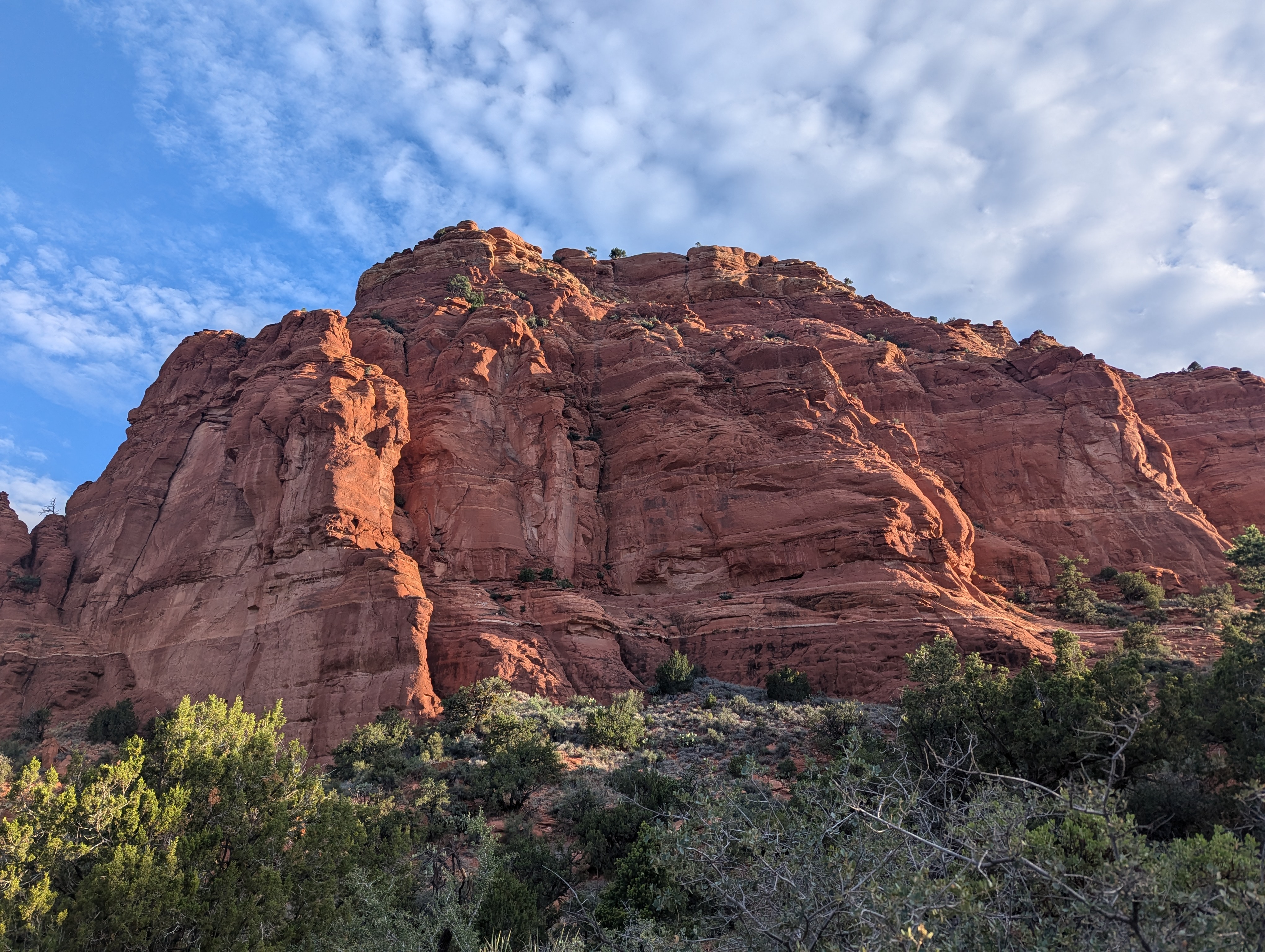
Bear Mountain (6,470 feet) looms to the front. Morning light paints massive shoulder rust-red and blood-brown. This is Schnebly Formation Sandstone, reminiscent of the flaming orange Entrada Sandstone I’d encountered in Arches National Park several years back, but unique to the “red rocks” of Sedona. Named, evidently, for Sedona Schnebly (1877-1950), an early pioneer to the area, drawn by the climate, who ran a boarding house where guests paid $1 per night; she became the namesake for the town.
I pad through fine-grained orange sand, silky underfoot. Pass a clump of silverleaf nightshade – my eye drawn to the purple star-shaped petals and prominent yellow stamens, and to the long thin dusty green leaves with abundant prickles. I think it was in Texas where I first developed an interest in the nightshade family (genus Solanum) but what drew my notice was the clusters of yellow balls bobbing in the autumn brush. I thought of tomatoes and peppers, which are also nightshades, but these yellow balls are not good to eat. Recently I was walking around a lake in Coppell, Texas, and recognized the purple-yellow flowers which I’d seen recently in New York’s Catskills, or at least a close cousin called Carolina horse nettle, with similar purple star-shaped petals and prominent yellow stamens and prickly leaves.
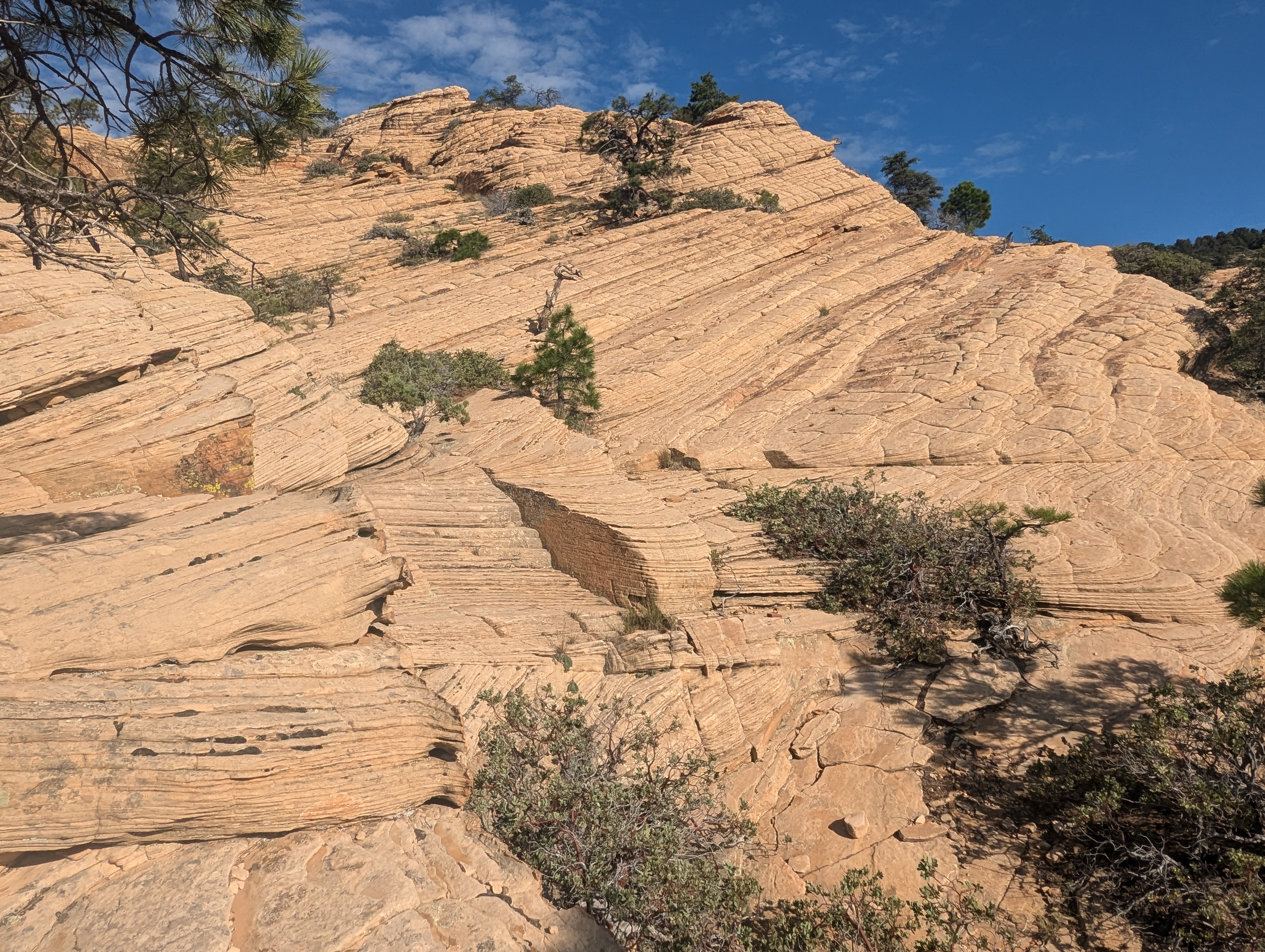
I climb 300 feet on a rocky trail. Traverse along a shelf. Then another rocky climb. Now I’m moving over cross-bedded Coconino Sandstone, which overlays the Schnebly formation. These wavey yellow slabs were once ancient dunes along some primeval shore. The material is smooth underfoot, except for long ridges in certain places, which I step on top of or over. The last climb takes me up another 600 feet, through piles of gravel. This must be limestone, I groan to myself, as I pick my way through the painful pieces. In my experience, limestone is the worst surface for barefooting since the brittle stuff fractures into sharp-edged fragments. Later I read this is Kaibab Limestone, the remnants of a siliceous ooze at the bottom of some ancient sea, and full of chert. You find it all over the Southwest, including the Grand Canyon.
The top of Bear Mountain is broad, covered with scrub brush, dense, scratchy, uninviting. I pick my way through more Kaibab limestone fragments, mindful of large ants scurrying past my feet. Spot a short tree casting shade. Find a flat rock to sit upon. Drink water. Eye the sun. Through the brush there are distant views of the San Francisco Peaks, some 50 miles north, the highest of which is called Humphreys Peak or Dooks’o’osłííd by the Navajo – “the peak which never thaws.” It is one of their four sacred mountains, demarcating the western boundary of the Dinétah, the people’s land, their ancestral territory.
Gus Bighorse’s father took him out for long rides starting when he was nine years old. From their home near Tzoodsił (Mt. Taylor in New Mexico, the southern sacred mountain), they journeyed to Flagstaff, rode around the base of Dooks’o’osłííd, continued on to the Grand Canyon, then turned north to Navajo Mountain and the Four Corners, passing the sacred mountains of the north (Dibé Nitsaa or Hesperus Mountain) and east (Sisnaajiní or Blanca Peak), and finally returning home to Mt Taylor. On this trip Gus remembers finding Navajo living peacefully in the desert, growing corn, watermelon, cantaloupe, peaches. They visited friends of his father among the Pueblo. Encountered white men in Santa Fe, who were friendly to the Indians. The reason for the trip — “We want to know how big the Navajo land is, and we find out. It is big. I can’t believe it.”
By the time he was 15, Gus had learned the lay of the land. This knowledge prepared him for his role – to become “a brave warrior,” a mantle he was proud and happy to take on. His father had also taught him that “a man should be right to stand up straight for what he believes.” This was in 1859, when the U.S. Army’s presence in the area was still quite limited.
The sun is now high overhead. It’s time to descend from Bear Mountain.
Half-way down, I encounter Vincent. He’s carrying a 200-foot rope, looking for a place to rappel. He’s from Taiwan, he explains in broken English, here on business, then noticing my feet, he breaks into a smile – Vincent runs barefoot. Except in Arizona, where he’s cautious about the cacti. He takes off one shoe, shows me a scratch on the heel. We take a picture together, and then I say goodbye. Because I need to keep moving. I feel the sun beating down. I feel my heart racing, and my breath is shallow. I must keep moving, or I will have to sit.
Down at the bottom, finally, the parking lot is in sight. But the soft orange sand is now burning. I stop in the shade of a small tree, almost in tears from the searing heat, fish out shoes from my pack for the last one-tenth mile.
I guess I wasn’t 100%. The next day I would’ve liked to climb Doe Mountain, but instead slept in. Had a croissant and cappuccino for breakfast. Made the 1-hour drive to Flagstaff. Had a glass of lemonade for dinner and went to bed early.
Slept in the next day, too. There is only the faintest tickle in the back of my throat, but I have no energy.
Is this a cold? The flu? One of those new variants?


Mt. Elden
The next day I’m feeling better, and it’s off to climb Mt. Elden (9,301 feet), where along the rocky trail I discover banana yucca and an orange-and-black hoary comma butterfly sitting on a yellow blossom. The trail is steep, rocky, hot. But when I reach the summit, clouds blow in, the wind picks up, and suddenly I’m crying from the cold.
According to the Internet, banana yucca is edible, although the Navajo prefer to cook it. When I take a nibble, it burns my throat.


Humphreys/Dooks’o’osłííd
A day off for some work calls, and now it’s time for the big climb – Humphreys Peak, or Dooks’o’osłííd, which at 12,633 feet, is the highest point in Arizona. This is some serious altitude for a New Yorker. The trail starts at 9,273 feet, at the base of a ski lift — the same elevation as Elden’s summit. I step through the parking lot, wincing on sharp gravel. The next half mile goes up the ski slope, steep and grassy, before turning into forest, where the path is a mix of gray rock and black dirt moist with dew. After 3.5 miles, I emerge onto a saddle between Humphreys and its neighbor, Mt. Aggassiz, and from this vantage a huge deep valley unfolds to the east. The San Francisco Peaks are the remnants of a stratovolcano, which is thought to have towered 16,000 feet tall before its last major eruption 400,000 years ago. This huge valley may have been the result of a lateral eruption which blew out this side of the mountain, like Mount Saint Helens, or maybe the side of the cone collapsed in a massive avalanche. From the saddle, I stare out through the valley onto distant plains. A faint pink smear might be the red sands of the Navajo Nation.
One mile to the summit along the exposed ridgeline. A long mile. I blink back incipient altitude-related headache. Step through chunky volcanic debris which litters the black sandy trail. There are multiple false summits, meaning you’re never quite there, there’s always one more climb. To the west, nothing but endless plains. From this direction the wind rages against the mountain unimpeded. “It was 70 mph at the summit,” a burly young man with beard and mirrored sunglasses tells me. He has that quiet confident look one associates with military operators. Later a young woman exclaims — “You did this barefoot?” – all smiles, she gives me a yoga bow – “you’re earthing!”
I stumble up the final climb. From the top, I look west for the Grand Canyon – yes, beyond a field of windmills, there is (I think) a long gash visible in the earth. To the south, endless forest. To the east, a sparkle of buildings, which is Flagstaff. To the north, that faint red smear again – the rocks and sands of the Navajo Nation, the 27,000-square mile reservation, with a population of nearly 400,000, which I’ll be driving through on my way to Colorado.
I camp out at the top for a moment. Watch a crow launch itself into the westerly flow, hover motionless, float down to its perch.
One day, when Gus Bighorse was sixteen, he went out to hunt rabbits and gather potatoes, berries, and onions. When he came home, he found his parents lying dead. Bows and arrows are scattered on the floor. Outside there’s a horse track and blood trail – it looks like his parents wounded or killed two of them. But they were not robbed. The silver his mom was working on is still there. So is the saddle and bridle his father was making.
Gus realizes that if he had been home, he would’ve been killed. Or, maybe he would have helped his parents fight off the threat. He reflects on his changed circumstances – “If somebody don’t have nothing, that don’t mean they’re poor. If you lose both your mom and dad, that means you’re poor.”
He buries them. Gathers the loose arrows. Heads up the mountain until he hears Navajo voices, including warriors. Listens to stories of other killings. How they burned the crops. The word is the enemy are soldiers from Washington. Gus finds a group of elders. “They talk to me like my father. They tell me to be brave….I think to myself, I want to be a brave warrior like my father taught me.”
Gus joins under Ch’il Haajini, a Navajo warrior known by his Mexican name, Manuelito. They prepare for conflict by scouting out the best places to hide and crafting stocks of arrows. There are skirmishes around Fort Defiance, where the soldiers are luring Navajo families with promises of free food. Manuelito expects enemy reinforcements. He leads the people deep into the mountains and canyons, where they go into hiding.
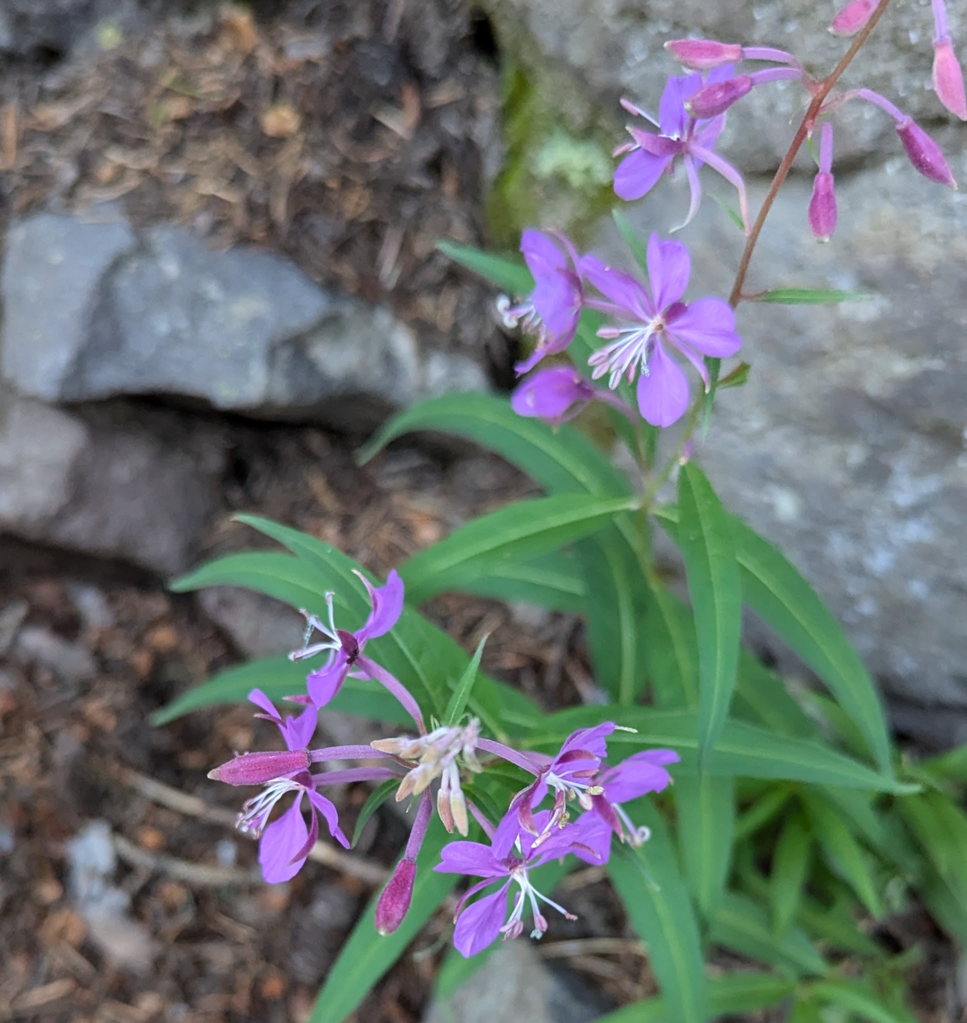
Back in Flagstaff, I get coffee. Do some shopping. Walking around the small tourist center, I notice a flower with dainty heart-shaped purple petals and white stamens. Recognize it as fireweed, which I’d seen once in the High Sierra when hiking the John Muir Trail – and how I remember the electric contrast — the fiery flash of fuchsia set off by the brilliant white of a granite block. But here I see the purple flowers growing everywhere. Like weeds. I walk into a shop, see a painting of a flower – “that’s fireweed,” I say, and the clerk nods.
It tends to rain in the afternoon. A front blows in a band of clouds shaped like a celestial donut. Thunder rattles. Rain taps against the window of my motel room, patters in the parking lot. Beneath bruised cloudbanks, the setting sun pours out shafts of molten gold and copper.

Driving through the Navajo Nation
It’s time to move on to Colorado. I brace myself for five hot dusty hours driving through the Navajo Nation. But the ride is comfortable, even with temperature reaching 97 F. I roll along with windows down, breath in the dry desert atmosphere – the wind feels cool across my face — while red sands and yellow mesas whip by. To the north, a glimpse of Navajo Mountain. On the side of the road, a row of striking red hoodoo formations. A sign reads Baby Rocks. I’d like to understand more, but at 70 MPH the pull-off flies past before I can react. I’d like to understand more about Hózho naashá – the Navajo ideal of walking the beauty path way, which is said to be a philosophy for living in harmony with the world.
There are no towns visible from the road. The 400,000 inhabitants of the Navajo Nation live spread out in the desert, where they move across the landscape tending crops and animals. The mystery-writer Tony Hillerman popularized Navajo culture by setting his stories in this region. He felt an affinity for the landscape, writing once that “those places that stir me are empty and lonely.” In one of his stories, a white woman observes, “I think it must be bad to be a Navajo if being lonely bothers you.” Joe Leaphorn, the Navajo detective she’s speaking to, and the star of Hillerman’s series, looks across the expanse of grass, brush, and erosion, which fades into blue distance. “The thought had never occurred to him.”
I stopped for food at the Bashas’ Dine’ supermarket in Kayenta, Arizona. It was clean and well-stocked, with layout and selection similar to those back home. There was even a Starbucks counter by the checkout. I bought a bag of cherries and an espresso. Then I noticed the security guard. He was strongly built, dressed in black, wearing a Kevlar vest. There were more black-garbed guards outside, where I sat on the pavement and sipped my espresso. I wondered about the security presence, but decided not to ask.
The battles between the Navajo and the US Army lasted for four years. During this time, the U.S. Army attempted to resettle the Navajo. They marched some 9,000 of the people east to a location near Fort Sumner, New Mexico. Those who couldn’t keep up on the march were abandoned or taken behind the roadside rocks and shot. At Fort Sumner they suffered from lack of shelter and inadequate food. Four years later, in 1868, the US government relented. Army officers signed a peace treaty, which led to the establishment of the Navajo Nation. The 4,000 people who were still alive made the long walk back home.
Gus had remained with the warriors guarding people in the homeland. But he heard stories. Of people walking barefoot, with nothing but loin clothes. Of one old lady who after two or three weeks of walking, finally saw Mount Taylor from the distance — the sacred mountain of the South. She started crying. “Mountain, we are home!” Fainted. Died two days later. Gus thought she’d died of happiness.
After the fighting wound down, Gus moved in with a relative and turned to farming. But his adventures were not over. One day, while out on horseback, he sees a group of Hopi Indians running towards him. Behind them are Mexican riders. He heads into a canyon but cannot find the trail out. The Hopi’s capture him, turn him over to the Mexicans, who ride him down to Mexico. He lives there for two years, assigned to a family as a personal slave. The family was nice to him. Fed him well. One day, the guard asked, would he like to go back home? Gus thought it was a joke. Until they provided him and another Navajo with horses and a map. They rode north for five days straight, letting the horses find their way to water. Gus knew he was home when he saw the silhouette of Dooks’o’osłííd.
Five hours in Navajo Nation pass uneventfully. Munching on cherries, I speed through the Four Corners region. In the distance, I spot a mountain with such a striking shape that I have to pull over at the visitor’s center in Durango, Colorado to enquire – learned it’s the Sleeping Ute Mountain, in the northern corner of the Ute Reservation.
Handies Peak
I’d programmed my first day in Silverton, Colorado as a rest day, which turned out to be fortuitous. Standing in the hotel lobby, I struck up a conservation with a gentleman sitting on the couch. Mentioned I was here to climb Handies Peak (14,048 feet), which would be my first Colorado 14er. Did I have a Jeep, he asked. Well, I’d rented a midsized SUV at the airport. To reach the trailhead requires crossing Cinnamon Pass, he explained. “You need high clearance and 4WD.” In preparing for the trip, I’d missed that detail somehow.
The next morning after breakfast, I went for a walk. Saw a red-painted building with posters advertising tours. Stuck my head inside. A small dog looked at me, sniffed at my bare feet, barked. “That’s Toby,” said the woman behind the counter. I asked her about doing Cinnamon Pass in my rental. She replied, “what about your tires?”
So I rented a Jeep. It was very similar to the Jeep I drive back home, but a 2021 model instead of 2017, painted silver instead of black, and with only 30 psi in the tires, for better cushion on rocks, instead of the 44 psi I drive around with on the highways back east.
I started out early, to leave time to get up and down the mountain before afternoon thunderstorms rolled in. Left Silverton in pitch black and light drizzle. Drove along a dirt road for several miles. Made the turn onto the pass. Shifted into neutral, engaged the 4WD, and inched forward in first gear. The road was a steep mess of potholes and protruding rock edges. I moved across the pass mostly at 5 MPH. In my rental, this would have been disaster.
The climb up Handies went smoothly. The trail was quite rocky at the start, so I aimed my feet for patches of grass, where they were available, but avoided the thistles mixed in. Further up, there was a section of clinkers I treaded carefully across, just as I’d learned to do in the High Sierra. Then the trail turned sandy. The final climb was steep but uneventful. At the top, I marveled at the expansive views. Although they were hard to process. Everything was so much bigger than what I’m used to back east. And foreign. I did not know a single peak or landmark.
On the way down, I spotted a small white flutter. Not being one to ignore such things, I crept closer – snapped a picture. Later identified the creature as the Parnassian Moth, named for Mt. Parnassus in Greece (8,601 feet), a holy mountain cloaked in olive groves, the home of the Delphic Oracle. The moth’s name reminded me of the Marsh Grass of Parnassus, a five-petaled white flower I’d seen in the High Sierra. A thought began to form – but I pushed it aside for some other day.


Mt. Elbert
Now was time for another five-hour drive. I departed Silverton through a rainbow, which is a symbol in Navajo culture, incidentally, for how the Holy People communicate with us. Five hours later, I pulled into the small mining town of Leadville, Colorado, coincidentally the day after the 100-mile Leadville ultramarathon took place, which I’d run 13 years before. I remember how difficult it had been to make it up and over Hope Pass (12,600 feet) to reach the half-way point. And how difficult it had been to make it up and over again on the way back. The race has strict time limits, so there was no choice but to “do or die.” I’ve successfully competed 110 races of marathon distance or longer. Leadville was number 32.
My mission today is not running, however. The goal is to climb Mt. Elbert (14,440 feet). Elbert is the tallest peak in Colorado, and the second tallest mountain in the continental U.S. behind Mount Whitney (14,500), which I’ve climbed twice barefoot and once in shoes. Elbert would be a big hike for me, at nearly 10 miles, with 4,500 feet of climbing. But the trails are mostly sandy. I make it to the top without issue. Hang out for a few minutes under clear sky and mellow sunshine. Try to take in the sweeping views.
Actually, I’d been on Elbert once before. On an Outward Bound patrol during early June 1982. The cadre had sent us out on our own, although an instructor was supposed to shadow us, just in case. We post-holed through snow drifts that were sometimes hip-deep. Eventually made it to the top, only to find the skies were ominously dark. One of the girls said she could feel static electricity running down her back. She was wearing an external frame pack with aluminum stays, and her down jacket was damp with sweat. “Everyone get down,” I shouted. Lying in the snow, I lifted one of my poles a few inches from the ground, felt the tingle running across my wrist. At this moment, the instructor materialized, shouted “fools, get off the mountain!” We careened downhill through the deep snow, not stopping until we’d reached the valley. At the bottom, we pulled out maps and compasses, but could not figure out our location. Someone saw a pick-up truck tooling down a gravel road. We waved it down, asked the driver for guidance, found out we’d gone down the wrong side of the mountain. Spent the rest of that long day walking.
That was 42 years ago. Today my descent from Elbert is straightforward. The only surprise is Matthew – another barefoot hiker. A young man from Boulder, he’s used to hiking barefoot there and wanted to show his friends he could bag a 14’er. He seems so comfortable and confident on the trail, while I feel, honestly, a little old and slow, especially on the downhills, where perfect foot placement and balance is requisite for every single step. “I’ll see you when you catch me on the way down,” I suggest, but he says probably not, as he’s going to hang out on the summit and beat an African drum he’s carrying in his pack.
The next day, I’m supposed to do Quandary Peak (14,271 feet), but I wake up in the middle of the night, anxious about work and other projects. So I opt instead for a rest day and get a lot done.


Mt. Royal
The next day I was supposed to bag two more 14ers, Grays and Torreys, but the weather forecast was concerning – with temperatures in the 30s at elevation and rain starting at 9:00 am. To get in and out before the rain, I’m up at midnight. On the trail at 2:00 am. Only to encounter a terrible rocky path which I could hardly walk upon. The wind picked up. It began to rain. I saw a light coming towards me. It was a hiker who’d turned back. Said this was his first 14er, he was concerned about the weather. Give it a few minutes, I suggest, maybe it will let up. He shrugs. I keep moving. The rain intensifies. Soon water is streaming down my Gore-Tex jacket and pants, and inside I’m starting to feel damp. I make my decision – to abort. I’d gone only 1.4 miles.
Later that morning, back in Frisco, where the skies are partly cloudy, after coffee and breakfast I decide to do a shorter, nearby climb. Found the trail to Mt. Royal (10,502) was located only a half mile away. After a short distance on a paved bike trail, the path turns up. Straight up. Steep, and the path so full of gravel, I’m just creeping. Half-way up, I see a trail runner descending. He told me he was doing repeats on this grade, no doubt training for an ultramarathon. “It’s called the stairway to hell,” he said.
At the top, everything is sharp rock. I creep along in slow motion. My feet don’t hurt — so long as I take each step exactly perfect. But that means moving in slow motion. Like at 0.5 MPH. I hung out at the top for a moment, then reluctantly fished out shoes (no way was I going to spend four hours getting back). And then a mountain goat appears. It walks calmly down the trail, passes a few feet from me with a sideways glance, then continues to the summit at an unhurried pace.
Back in Frisco, I’m sipping coffee, watch hail bounce off the sidewalk.
After his escape from Mexico, Gus returned to farming, married, and raised a large family. He would tell stories about his life to the boys, explaining “nowadays the men and the boys should be thinking about how they could survive like I survived. It must be in your thinking to be brave and to be safe.”
His daughter, Tiana, used to listen to his stories, too. But the boys didn’t like that, since these were stories for men. They complained to Gus, who reprimanded her. From that point on, she pretended to sleep while he talked. But later, Gus found that the boys had forgotten much of what he said, while Tiana remembered every word.
He had other reasons for sharing his experiences. “I want to talk about my tragic story, because if I don’t, it will get into my mind and get into my dream and make me crazy. I know some people died of their tragic story. They think about it and think about how many relatives they lost. Their parents got shot. They get into shock. That is what kills them. That is why we warriors have to talk to each other. We wake ourselves up, get out of the shock.”
Fifty years after hearing her father’s stories, Tiana decided to publish them in a book. “These are brave stories, and knowing them can make you brave. I don’t want to just throw away what he told us. Right now the young generation knows nothing. They don’t know stories about anything. They just think that this is our land and it was given to us by the Great Spirit. But their great-grand ancestors didn’t tell them. The reservation was fought for.”
As she was working with her editor, Tiana wanted to clarify something. What does it mean in the Navajo culture to be a warrior? She explained that warrior means “someone who can get through the snowstorm when no one else can.” Someone who can tend to the sick because he doesn’t get the flu when everyone else does. In Navajo, a warrior is the one “who can use words so everyone knows they are part of the same family.” The warrior says what is in the people’s hearts. Talks about the land. Brings the people together to fight for it.
When they see me hiking and running barefoot, people sometimes call me “warrior.” For example, a woman called me this when she saw me on Rocky Ridge Peak in the Adirondacks, which was part of a 16-mile hike with 5,000 feet of elevation gain — and someone else said the same thing when I was running barefoot in an 12-mile race in the Shawangunk Mountains. I used to be a warrior. I wore Vietnam-era jungle fatigues and carried an M-4, which is a fully automatic carbine version of the AR-15. But that was a long time ago. In American culture, the term “warrior” is reserved for those in active duty military roles with combat missions.

Heading Home
With Mt. Royal in the bag, I wrapped up my travels and pointed myself back home.
It had been a lot of travel for six (6) barefoot peaks. Which brought my total to 405, meaning I have 595 left to do. In my remaining lifespan, however long or short that may be. In my remaining healthspan, which for Americans averages only 64 years.
I am intrigued by the Navajo’s attachment to their land, and the importance to them of the four cardinal points that demarcate the Dinétah. Hesperus and Blanca are said to be difficult climbs, but I found a video of a young couple who hiked to the top of Tzoodsił (Mt. Taylor) in New Mexico. It looks like a fun trip for next summer.
But next summer is so far away. What about Parnassus – could I get away to sunny Greece over the holidays? But online data shows that Parnassus is quite frigid in the winter.
I have a bigger problem. Since I can go almost anywhere, there are no obvious cardinal points for me. I am a modern person, my traditions, culture, and ancestral homelands lost or “atomized,” leaving me adrift in an anonymous global consumer marketplace. The best I can do is learn to feel at home in different homelands.
Instead of four cardinal points, I have but two: the start of this project, meaning zero mountains climbed, and the finish, when I reach 1,000. In between these points lie a large quantity of uncomfortable rocks (including Kaibab limestone), and everything else is mystery.
Running the Long Path is my account of a 350-mile run in pursuit of a fastest known time record and what I discovered along the way. (Click on the image for more info)

[…] This summer I summited some big ones, including the Navajo’s sacred mountain of the west, Dooks’o’osliid AKA Humphrey Peak (12,633 feet) outside Flagstaff, Arizona, and Colorado’s Mt. Elbert (14,440 feet), the second-tallest peak in the continental US. It was slow work, though, with six summits eating up two weeks of precious vacation time, a rate of progress so slow I might well be 100 years old before I finish. […]
LikeLike
[…] I have become the first person to complete this list without shoes. During a summer trip to Arizona and Colorado, I climbed mountains ranging from 6,000 to 14,000 feet, including Mount Elbert (14,444 feet), which […]
LikeLike
[…] [iv] https://thelongbrownpath.com/2024/08/27/peak-bagging-in-az-and-co/ […]
LikeLike