Driving up to the Catskills early one morning, it was another dim day, with overcast skies smothering the light and fresh snow blotting out the subtle colors of the winter landscape. The Shawangunk Mountains slid by in the rear view mirror, slate gray and dusky taupe. The Catskills’ southern mountains looked like a bank of fog. The scene lacked energy, but this doesn’t matter when there are mountains to climb….
Met my friend Alan at the Phoenicia Diner, and soon we were on our way to a parking area on Spruceton Road just beyond the town of West Kill, which lies along the West Kill creek and consists of little more than post office, flag pole, and handful of homes.
Six inches of soft powder were waiting for us, with no footprints on the trail except for deer, rabbit, and squirrel. After a mile the trail turned left toward West Kill Mountain, and here we turned to the right, drew a compass heading toward the summit of North Dome, and stepped into the woods. The forest was open, and the slope relatively easy, and we made good progress, at a couple of points working around rows of ice-covered rock ledges, but that was no big deal. A little while later we entered the boreal zone and found ourselves weaving through a maze of snow-covered fir trees before locating the summit and signing in at the canister.

Our next objective, Sherrill Mountain, lay farther to the west. After exiting the boreal zone, we could see Sherrill looming a mile or so in the distance, while before us the slope dropped off into the intervening saddle. We ran downhill, skidding down the steeper snow-covered embankments, tripping occasionally on buried rocks and logs, and clumping through untracked powder until finally the saddle lay in front of us like a bridge leading from one mountain to the next. Soon we were making our way up Sherrill, and now the going got steep. I was using hands as well as feet, but the snow was firm, and in due course we reached the summit, which like North Dome was cloaked in an grove of snow-enshrouded fir.
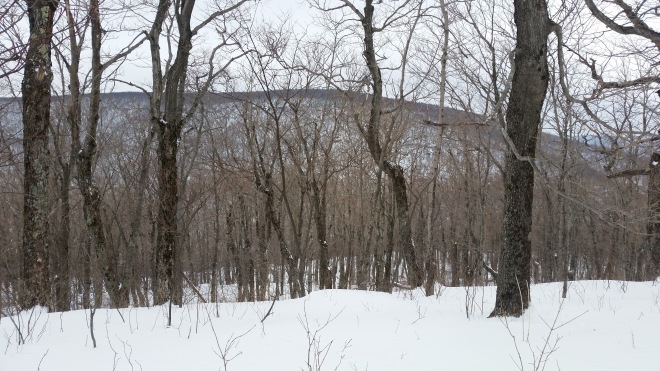
The descent from Sherrill was more difficult. The temperature had risen a little, and the fresh snow pack had become crunchy, but on this north-facing slope there lurked an icy crust underneath the snow. With one step you’d crunch to a halt, but on the next step your feet might fly out from under you, sending a mini-avalanche sliding a few feet downhill. We picked our way down the slope, our pace slowing to a veritable crawl. Down below us in the valley lay the West Kill stream and Spruceton Road, which would lead us back to the car. Across the valley lay a long ridgeline. According to the map we were looking at Pine Island and Pack Saddle Mountains and between them there was a deep notch; putting away the compass I used the notch as a reference point to steer us straight, and finally we caught sight of the road.


It was a relief to put this grinding descent behind us, but now we faced a new obstacle: the West Kill stream, which was flowing fast and wide, without obvious places to cross. We walked near the bank, stepping gingerly on crusty ice plates which groaned under our weight. Then a plate broke apart underneath me — I tried to hop back to shore, but it was too late, both feet plunged into the water, and it seemed there was no better option than to get to the other side. The channel turned out to be knee-deep. After a few seconds, the cold became quite painful: there were tears in my eyes by the time I reached the far shore.

Eventually we made it back to the car, and a change of socks later drove off to the Platte Clove parking area for our next mountain, Kaaterskill High Peak. Enough bushwhacking, it would be a relief to stick to trails on this climb, or so we thought, and blissfully unaware of what lay in wait for us, we hustled along. I had switched from snowshoes to spikes, and these admirably gripped the snowy surface of the trail which had been trampled by a number of earlier hikers, it somehow having become late afternoon. Two brisk miles later, we took a shortcut through the woods to reach a snowmobile trail and found ourselves once again stepping through fresh untracked powder. And then we were standing at a cairn and looking around for the blazes that would take us up the last 500 feet to the summit. This is an unmaintained trail, and having been here once before, I knew the blazes were few and far between, and the trail quite steep. The light was fading.
We quickly lost the trail. I had a brilliant idea: “let’s work around to the left,” I told Alan, “it looks less steep.”
And at first, it was only a 30% grade or so, but that didn’t last long. Soon I was using hands as well as feet, and then the slope got even steeper. It was completely dark now. Craning my neck, I peered upwards and spotted bands of white, but couldn’t tell whether it was rock ledges or snow-covered fir trees. Our headlamps lit up the welter of saplings, branches, and twigs that immediately surrounded us, but these blinded us to what lay farther ahead. I crawled up a little ways, my feet slipping on ice-covered rock faces underneath the snow. Strangely, my spikes didn’t get any purchase, even when I pressed down hard. And then, up ahead was a wall of rocks, covered in sheets of ice and snow, without visible hand or footholds.

There was no way up. I ventured around to the left, clinging to the snowy slope with hands and feet, searching for a route, while Alan looked to the right, but the cliffs were relentless.
A retreat was in order. We fell back, dropped a hundred feet or so, and regrouped. The new plan was to work around to the right with the hope of regaining that unmaintained trail. We saw no blazes, but after a little discovered a somewhat more manageable slope. We toiled slowly upwards, but once again the slopes steepened until hands, feet, and even knees were needed, and without branches to grasp, I couldn’t make it any further. Struggling desperately, my foot slipped out from under me, and my face went straight into a pile of snow, which didn’t improve my mood. Why weren’t my spikes giving me any traction? We gave up again.
“I’m OK if we don’t make it to the top,” I told Alan. We were both mindful that a slip and fall of even a few feet could send one crashing into rock or tree, risking injury, and if that happened, this would be a difficult spot to effect a rescue, and that we’d put our rescuers at risk in this terrain, and that it would in any case take a really long time to summon help.
Once again, we retraced our steps and moved across to the right. Once again the slope steepened and we encountered the wall of rocks, but this time there was a small tree growing from a ledge just above our heads. On the snow-covered ice, each step was a battle. The tree was just out of reach. I kicked away the snow around my feet, revealing a small foothold, which gave me a few more inches. Grunting with effort, I made it within reach of the tree and hoisted myself on top of the ledge, and Alan was right behind me. We had finally reached Hurricane Ledge, just below the summit. Miles away to the southeast the lights of Kingston glimmered in the dark.
At the summit, I decided to switch back into snowshoes, and now I discovered that my spikes had slipped off the front of my shoes and bunched up on the heels. This explained why I had so little traction when standing on the balls of my feet.
We had no appetite to return the way we came, so we opted for the longer route home down the north side of Kaaterskill High Peak. The trail was steep and slippery, but easy to follow, and we slid down much of the way on our butts.


Running the Long Path is now available on Amazon – click on the image to check it out

[…] relatively straightforward until I reached a line of cliffs guarding the summit, which brought back memories of the desperate climb to this summit in the winter, when the steep rocks were sheathed in ice and snow. Now I was […]
LikeLike
[…] they slid down on their butts. I’d done the same during a trip here last winter after a difficult nighttime ascent from the south. That trip had been memorable, but frustrating: I’d slipped and scrambled upwards across […]
LikeLike
[…] bands along Kaaterskill’s northwestern edge and pick out Hurricane Ledge just above them. A couple of winters ago, Alan and I had scrambled up through those rocks with great difficulty, on account of snow and ice […]
LikeLike