The goal was The Nine, a 20-mile loop in New York’s Catskill Mountains that connects nine of the highest peaks, with the special challenge that four of the mountains have no trail, meaning you must bushwhack through the woods using map, compass, and/or GPS. I had completed The Nine before during the summer, so you might assume I’d feel pretty confident. But now it was winter. And the prospects of navigating over rugged terrain, contending with treacherous footing, braving the cold — this was a little daunting.
Thus I was ecstatic when Iain Ridgeway and Aaron Anaya responded to my post on the Mountain Peak Fitness Adventure Club’s Facebook page. Iain is an elite racer, whose many accomplishments include winning the marathon division of the Ellenville Mountain Running Festival. Aaron is an experienced trail runner, mountain biker, and adventure racer, who was familiar with the Nine having recently summitted the Catskills’ 35 highest mountains together with his daughter.
The night before, I laid out my gear. With temperatures forecast in the 20s and reports of ice and snow on the trails, safety would be paramount. That meant micro-spikes for traction, plenty of layers for warmth, lights in case we returned late, and extra batteries for phone/GPS. Even so, it was a trail-runner’s load-out: no tent, sleeping bag, stove, mattress pad, food, or other safety gear that a hiker might have carried. If I got lost or injured, it would mean spending an uncomfortable night in the mountains. To mitigate this risk, the load-out included a SPOT Messenger, which would broadcast my location using satellite phone technology and which could alert first-responders at the push of a button. But even better than high-tech gear was having companions.

The three of us met at the trailhead at 8:00 AM and were soon moving along a crusty, ice-covered trail toward the first objective, Table Mountain. With long legs and purposeful stride, Iain set a brisk pace, leading us forward at what my GPS watch indicated was a steady 3-4 MPH. At this pace, we’d be back before dark — an encouraging thought, if unrealistic.
Microspikes provided adequate traction on the ice, but soon the trail turned up steeply, and after rising a thousand feet, we were trudging through several inches of snow. Looking around, snow blanketed the forest floor and covered every tree, and underneath the snow was a sheet of ice. My feet began to slip. I noticed that Iain and Aaron’s microspikes had large metal fangs, while mine were toothless, microspikes in name only. Now the watch showed 1-2 MPH and with sinking heart I realized that this trek might take a really long time. I placed each foot carefully and struggled to keep up.

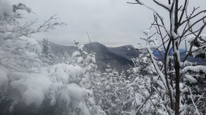
The trail tunneled through dense fir-spruce forest, and when we passed Table’ summit, there was nothing to see but a small pile of rocks. We jogged downhill for a short distance and then made the quick climb to our second goal, Peekamoose Mountain, whose summit is marked by a large pointy block of sandstone conglomerate sitting in a small clearing. There’s an exposed ledge a few yards from the boulder, but under the lowering sky there seemed little point in seeking a view.
Peekamoose was the end of the trail for us. The next four peaks lay strung out along the ridgeline somewhere to the north, cloaked in dense forest. We peered into a maze of short conifers, remnants of the boreal forest that once covered the entire region, and searched about for the best spot to enter the woods. With some of the summer vegetation having died back, I wondered whether winter bushwhacking would be easier. Or whether it would be even worse. I looked at the NY-NJ Trail Conference map displayed on my phone and compared our current location to waypoints recorded during my previous attempts on The Nine. Aaron and I pulled out compasses and conferred on the most direct magnetic azimuth to follow. Then the three of us plunged into the shadows…
…and found ourselves careening down a snow-covered icy slope, sliding downhill, zigging and zagging around the trees. We were moving quickly, and this was reassuring. However, after a few minutes of steady progress, I pulled out the phone for a map check. Small mistakes made early on can result in costly detours. And indeed, the display showed that we had drifted too far downhill and were now a little off course. No big deal. We reoriented and headed out again. After a few minutes, I checked again, and we were further off course. With every step, we were apparently sliding a few feet down slope, as if the forest was trying to suck us down into the valley far below. We began moving along the side of the ridge, trying to follow the contour without sliding further downhill.
A couple more corrections were necessary, but we eventually made it to the shoulder of Lone Mountain, our next objective, and now the task became simpler: just head uphill. A nice feature of topology is that if you keep moving up, you must eventually arrive at a summit. The three of us jokingly called it the “rule of up,” and putting away compasses, took one step at a time, squeezing between trees and around boulders, until eventually we made it to the top of Lone. From a vantage point on the summit’s eastern edge, we caught a glimpse of the frost-encrusted ridgeline stretching away to the north.
Despite the course corrections, the first bushwhack hadn’t gone too badly, and we felt encouraged. Out came maps, compass, and GPS, and we plotted our course to the next mountain, Rocky. An adventure racer and former marine, Aaron is well versed in using map and compass and listening to my directions, he made an observation: when converting azimuths from grid north (on the paper or electronic map) to magnetic north (for the compass), I was subtracting the 13 degree westerly declination — when I should have been adding it. That mistake would explain why we had been drifting off course.

Leaving the summit of Lone, we discovered fresh tracks in the snow. Evidently a group of hikers had traveled this way quite recently. These must be experienced hikers, I reasoned, and with some luck, we’d follow these tracks straight to each of the next four mountains. Nothing could be easier. But after a short distance, instead of taking us downhill and north into the saddle between Lone and Rocky, the tracks turned east. Our patience wore thin. We abandoned the tracks and turned downhill. But within a few yards, progress was blocked by a row of cliffs that were too steep and slippery to get down. Now it became clear: whoever left the tracks was navigating around these cliffs. We went back, rejoined the tracks, and continued further east again, expecting the tracks to shortly turn north. But they kept east. After a little while, I made a command decision and led Iain and Aaron straight downhill again — only to encounter yet another set of cliffs. Determined to find a route, I started working my way around to the left until there was a new surprise: more tracks. I stared at them, perplexed, until Aaron pointed out they were ours, as we had gone in a circle.
Eventually we did find a passage down through the cliffs, made our way across the saddle, and headed up toward Rocky, whose summit was guarded by yet another line of cliffs. We worked around to the right until we discovered a chute between rock slabs leading up at a steep but negotiable angle. Grabbing onto roots and branches, we pulled ourselves up step by step onto the summit. Traction was a challenge in my toothless spikes, so I moved slowly, bringing up the rear. Once on top, Aaron signed our names in the notebook contained in the Catskill 3500 Club canister. With four mountains done and five to go, we were feeling pleased.
The next objective, Balsam Cap, is notorious for the balsam-fir thickets that guard the summit; it’s thought to be one of the Catskills’ most painful bushwhacks. Balsam fir saplings grow so closely side by side, that you can barely squeeze through the interlocking branches — and even worse, as you’re stumbling through the thickets, you encounter deadfall and now must climb over two or three giant trees that have crashed to the ground, jagged branches radiating from their trunks, threatening to impale you. Forward motion seems impossible. For runners used to covering ground at a brisk pace, the slow progress breeds frustration, anxiety, eventually panic.
This time around, I felt reasonably confident, having experienced this bushwhack before. I moved forward steadily, pushing the branches away with my hands, looking ahead for obstacles, shifting body between trees, twisting quickly when clothing snagged. I’ve learned that the worst tangles don’t last forever; when you finally make it over the deadfall, the terrain sooner or later opens up, at least enough to keep moving. As I was thinking this, a branch slipped from my outstretched hand and whipped back, slapping me with a load of snow in the face.

We eventually made it to Balsam Cap, and then descending on the far side, encountered more of these thickets. We figured they wouldn’t have named it Balsam “Cap” if the summit wasn’t capped in thickets on all sides. Suddenly, to our surprise, there were voices, and a group of hikers materialized, including a guide whom Aaron recognized from a previous trip. Since they had just come from Friday, our next objective, and seemed very experienced, we made the decision to follow their tracks. This time, nothing could go wrong. And we sailed through the woods for a few hundred yards, until their tracks began to veer downhill. To the left a sheer wall of rock guarded the ridge. We were unhappy to cede altitude, which we’d have to make up. And so, after a few more yards downhill, we abandoned the tracks, found a notch in the rock wall and struggled up to the summit, where we saw their tracks coming in from the side. Who had taken the quicker route was hard to tell.

Now it was time for the last bushwhack, which was to take us out onto the trail that leads to Cornell Mountain. We had had enough of fighting with the Balsam fir, we couldn’t wait to get back on a trail. The forest was still thick, but it helped that the ridge was narrow, and we were able to stay on the spine just to the left of a long row of cliffs. We slowly made our way north and after steady progress, I checked the map and was relieved to find we were within a hundred yards of the trail. Each of us breathed a great sigh of relief. I told Aaron and Iain, just follow the “rule of up.” And up we went, and then we went up further, and the trail had to be just ahead, but strangely it wasn’t. I could tell that Iain’s patience was wearing thin, and as for myself, I was breathing through pursed lips in an effort to stay calm, totally at a loss as to why we hadn’t yet reached the trail. Eventually, we popped out on the summit of Cornell. The rule of up had worked, it’s just that “up” had taken us around to the right, causing us to miss the trail by just a few yards and bushwhack a little longer than was strictly necessary.
What a pleasure to be out of the woods! But it was now late afternoon. We held a council of war. I reported that the SPOT Messenger’s batteries had died. As such, for the sake of prudence, we decided to skip Wittenberg. Instead, of The Nine, we would complete The Eight — and perhaps we would be the first to document completion of this particular route, earning the right to a fastest known time. With Iain in the lead, we trotted downhill to the saddle between Cornell and Slide Mountain and then headed up to the summit. The trail crossed a ledge and followed a crack in the rocks. There was no traction for my toothless spikes, and I groped around unsuccessfully for a handhold. Aaron reached out his trekking pole and hauled me up. The trail became steep, and I fell behind again. Clambering up a rock, the muscles in my left leg began to cramp. I took a deep breath, focused on shifting the load to other muscles, and the cramps eased.

We made it to the summit of Slide, which is the Catskills’ highest peak, as dusk was deepening into night. The half moon shone through a layer of haze. We admired a plaque dedicated to the nature write John Burroughs, and then ran downhill for the next five miles, snowflakes dancing in headlamp beams, not stopping until we reached the trailhead and the safety and comfort of our cars.

It was a great adventure. Even if we missed one peak out of the nine. Thank you to Iain and Aaron for joining me on this expedition, and thank you to the MPF Adventure Club for hosting the Facebook page that helped us link up. Friends have recommended the most tenacious microspikes on the market, and once equipped with metal teeth on my feet, I’ll be back in the Catskills for more icy fun.


[…] slipping and sliding on microspikes that didn’t have spikes, I got a pair of the real thing from Catskill […]
LikeLike
[…] the forest. I’d run the Nine twice before during the day and once at night and also bagged eight of the nine during the winter. But this time I’d be going without shoes, part of a quixotic quest to climb all 35 of […]
LikeLike
[…] been here and done this before, as I recall from an unsuccessful winter attempt on the Nine in January 2016. The saddle before Balsam Cap is dense with fir saplings, and then it’s steeply uphill […]
LikeLike
[…] [Author’s note: after writing this blog post, I recalled that my first ever winter bushwhack was almost a year earlier, when some friends and I attempted to complete the Nine.] […]
LikeLike
[…] the Nine, or parts thereof, on several occasions: once trying to run it for speed, once at night, once in the winter. In April 2016, as a novice barefoot hiker, I tried to complete the Nine without shoes, but after […]
LikeLike
[…] On May 9, 2015 I was trying to go fast. I climbed Peekamoose and Table and then headed into the thickets, where I managed to go around in circles (even with a GPS) and nearly got scratched to pieces. I returned on May 17, 2015, thinking I ought to have practice bushwhacking in the dark, and ran the Nine at night, emerging on the summit of Wittenberg in the orange glow of dawn. On January 17, 2016, I came out with Aaron Anaya and Ian Ridgeway to run the Nine in winter (we skipped Wittenberg and settled for the Eight). […]
LikeLike